 Visualizza questa pagina in Italiano
 HOME PAGE
|
Visualizza questa pagina in Italiano
|
HOME PAGE
|
Legend and translations |
| USA - UNITED STATES | |||||||||||||||||||||
| ADDISON AIRPORT | |||||||||||||||||||||
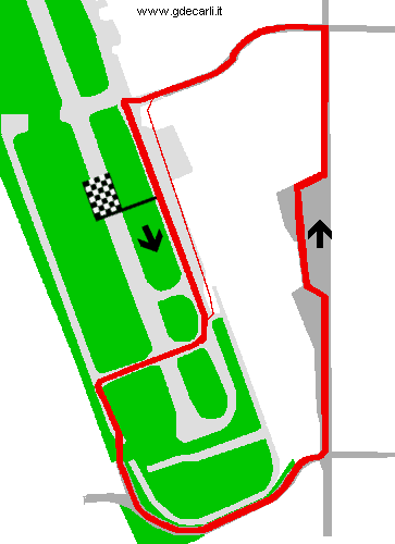
| Description | Temporary circuit built on the runways, perimeter roads and streets surrounding an airport still in use. It was used by SCCA Trans-Am from 1989 to 1991. It was abandoned because of excessive heat, lack of parking, poor access, and airline passengers protests. | ||||||||||||||||||||
| Location | Dallas TX - Texas - Southern States | ||||||||||||||||||||
| Location | Addison Airport, in a northern suburb of Dallas | ||||||||||||||||||||
| Latitude - Longitude | + 32°57'48" - 96°49'59" 32.963333 -96.833056 | ||||||||||||||||||||
| UTM Coordinates | X = 702530.419 - Y = 3649306.5 - Zone 14S | ||||||||||||||||||||
| Aerial photo / Map (*) |  Google Maps - Bing Maps - Flash Earth - Microsoft Research Maps - MapQuest Google Maps - Bing Maps - Flash Earth - Microsoft Research Maps - MapQuest | ||||||||||||||||||||
| Altitude AMSL | 195 m - 640 ft | ||||||||||||||||||||
| Inauguration | 1989 | ||||||||||||||||||||
| Closing | 1991 | ||||||||||||||||||||
| Designer | Wilson Motorsport | ||||||||||||||||||||
| Sources and links (Translation) (**) |
| ||||||||||||||||||||
| Addison Airport | |||||
| Description | |||||
| Years | 1989÷1991 | ||||
| Direction |  Anticlockwise Anticlockwise | ||||
 Proposal Proposal |
NO | ||||
| No longer operational | YES | ||||
| Car Circuit | YES | ||||
| Motorbike circuit | |||||
| Type | Airfield course | ||||
| Inauguration | 1989 | ||||
| Closing | 1991 | ||||
| Last update of this page | July 9th 2007 | ||||
| Info last update | |||||
| Designer | |||||
| Distinctive points | |||||
| length | 2527 m | 8289 ft | 1.57 mi | ||
Addison Airport
| Updates | |||||||
| Date | Track layout | Years | Description by | Map by | Thanks to | Note | |
| June 20th 2006 | Guido de Carli | Lorenzo Tommasi | Update | Map | |||
| June 2nd 2006 | Guido de Carli | Update | Description | ||||
| April 9th 2006 | Guido de Carli | Guido de Carli | Lorenzo Tommasi | New | Description with map | ||
| November 22nd 2005 | Guido de Carli | Lorenzo Tommasi | New | Description without map | |||
| June 7th 2003 | Guido de Carli | Update | Description | ||||
| Not all eventual updates issued in last years are already visible in this list | |||||||
Webmaster:
Guido de Carli

(Italiano - English - Español)
HOME PAGE