 Visualizza questa pagina in Italiano
 HOME PAGE
|
Visualizza questa pagina in Italiano
|
HOME PAGE
|
Legend and translations |
| USA - UNITED STATES | |||||||||||||
| NEW ORLEANS SUPERDOME (1992÷1995) | |||||||||||||
| Description | After some complaints arose after 1991 edition, from 1992 to 1995 (included) IMSA races were moved 1 km - 0.62 mi West, in Astrodome area. There were some more complaints, because some important streets were closed for the race. In 1995 the race was moved from June to October, as final event of the championship, in order to avoid usual hot temperature, but it was not enough to save the race: 1995 edition was the last. It’s very difficult to see the circuit on the aerial photo | ||||||||||||
| Location | New Orleans LA - Louisiana - Southern States | ||||||||||||
| Location | Around Louisiana Superdome | ||||||||||||
| Latitude - Longitude | + 29°57'08" - 90°04'47" 29.952222 -90.079722 | ||||||||||||
| UTM Coordinates | X = 781850.509 - Y = 3317079.33 - Zone 15R | ||||||||||||
| Aerial photo / Map (*) |  Google Maps - Bing Maps - Flash Earth - Microsoft Research Maps - MapQuest Google Maps - Bing Maps - Flash Earth - Microsoft Research Maps - MapQuest | ||||||||||||
| Altitude AMSL | 1 m - 3 ft | ||||||||||||
| Inauguration | 1992 | ||||||||||||
| Closing | 1995 | ||||||||||||
| Designer | |||||||||||||
| Sources and links (Translation) (**) |
| ||||||||||||
| New Orleans Superdome (1992÷1995) | |||||
| Description | Reconstruction on aerial photo could be slighlty approximated | ||||
| Years | 1992÷1995 | ||||
| Direction |  Anticlockwise Anticlockwise | ||||
 Proposal Proposal |
NO | ||||
| No longer operational | YES | ||||
| Car Circuit | YES | ||||
| Motorbike circuit | |||||
| Type | Street course | ||||
| Inauguration | 1992 | ||||
| Closing | 1995 | ||||
| Last update of this page | May 19th 2010 | ||||
| Info last update | |||||
| Designer | |||||
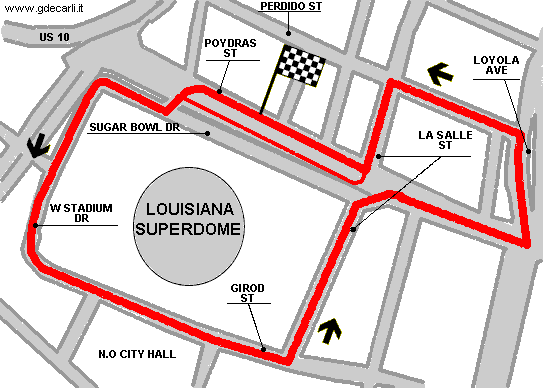
| Distinctive points | Poydras Street - Sugar Bowl Drive - West Stadium Drive - Girod Street - La Salle Street - Poydras Street - Loyola Avenue - Perdido Street - La Salle Street | ||||
| length | 2301 m | 7550 ft | 1.43 mi | (3) | |
| length | 2311 m | 7582 ft | 1.436 mi | Calculated from aerial photo (*) | (2) |
New Orleans 1990÷1991 and 1992÷1995
Due to technical problems, temporarily it’s no longer possible to see the circuits on Google Maps embedded in the current page.
This feature will be restored as soon as I figure out how to do (any help would be appreciated!)
See this track layout with Google Maps - Google Earth
(milermeter.com can be used in your browser, without installing anything; Google Earth is a program that must be installed in your computer)
(Map shown here above can show at the same time all eventual layouts drawn. If you want to see only some of them, please go to Google Maps or Google Earth, by clicking on its own link)
New Orleans Superdome (1992÷1995)
Due to technical problems, temporarily it’s no longer possible to see the circuits on Google Maps embedded in the current page.
This feature will be restored as soon as I figure out how to do (any help would be appreciated!)
See this track layout with Google Maps - Google Earth
(milermeter.com can be used in your browser, without installing anything; Google Earth is a program that must be installed in your computer)
(Map shown here above can show at the same time all eventual layouts drawn. If you want to see only some of them, please go to Google Maps or Google Earth, by clicking on its own link)
| Updates | |||||||
| Date | Track layout | Years | Description by | Map by | Thanks to | Note | |
| May 19th 2010 | 1992÷1995 | Guido de Carli | Guido de Carli | Update | Description with map | ||
| December 10th 2005 | 1992÷1995 | Guido de Carli | Lorenzo Tommasi | Update | Description | ||
| November 22nd 2005 | 1992÷1995 | Guido de Carli | Lorenzo Tommasi | New | Description with map | ||
| November 12th 2005 | 1992÷1995 | Guido de Carli | Guido de Carli | Lorenzo Tommasi | New | Description with map | |
| Not all eventual updates issued in last years are already visible in this list | |||||||
Webmaster:
Guido de Carli

(Italiano - English - Español)
HOME PAGE