 Visualizza questa pagina in Italiano
 HOME PAGE
|
Visualizza questa pagina in Italiano
|
HOME PAGE
|
Legend and translations |
| ESP - SPAIN | |||||||||||||||||||||||||||||||||||||||||||||||||||||||||||||
| MONTJUICH | |||||||||||||||||||||||||||||||||||||||||||||||||||||||||||||
| SORRY, SOME DATA ARE NOT TRANSLATED YET | |||||||||||||||||||||||||||||||||||||||||||||||||||||||||||||
| Not to be confused with | Barcelona (Castelldefels) - Barcelona, Carlos III - Barcelona, Parque de Barcelona - Catalunya (Barcelona) - Pedralbes | ||||||||||||||||||||||||||||||||||||||||||||||||||||||||||||
| Description | |||||||||||||||||||||||||||||||||||||||||||||||||||||||||||||
| Location | Montjuïc / Montjuich, Barcelona B - Barcelona - Catalunya / Cataluña | ||||||||||||||||||||||||||||||||||||||||||||||||||||||||||||
| Location | |||||||||||||||||||||||||||||||||||||||||||||||||||||||||||||
| Latitude - Longitude | + 41°21'59" + 2°09'03" 41.366389 2.150833 | ||||||||||||||||||||||||||||||||||||||||||||||||||||||||||||
| UTM Coordinates | X = 428980.358 - Y = 4579778.833 - Zone 31T | ||||||||||||||||||||||||||||||||||||||||||||||||||||||||||||
| Aerial photo / Map (*) |  Google Maps - Bing Maps - Flash Earth - Visor SIGPAC Google Maps - Bing Maps - Flash Earth - Visor SIGPAC | ||||||||||||||||||||||||||||||||||||||||||||||||||||||||||||
| Altitude AMSL | 100 m - 328 ft | ||||||||||||||||||||||||||||||||||||||||||||||||||||||||||||
| Inauguration | 1933 | ||||||||||||||||||||||||||||||||||||||||||||||||||||||||||||
| Closing | 1986 | ||||||||||||||||||||||||||||||||||||||||||||||||||||||||||||
| Designer | |||||||||||||||||||||||||||||||||||||||||||||||||||||||||||||
| Sources and links (Translation) (**) |
| ||||||||||||||||||||||||||||||||||||||||||||||||||||||||||||
| Montjuich | |||||
| Description | |||||
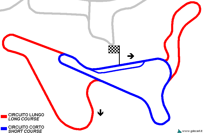
| Years | 1933÷1986 | ||||
| Direction |  Anticlockwise Anticlockwise | ||||
 Proposal Proposal |
NO | ||||
| No longer operational | YES | ||||
| Car Circuit | YES | ||||
| Motorbike circuit | YES | ||||
| Type | Street course | ||||
| Inauguration | 1933 | ||||
| Closing | 1986 | ||||
| Last update of this page | January 15th 2010 | ||||
| Info last update | |||||
| Designer | |||||
| Distinctive points | |||||
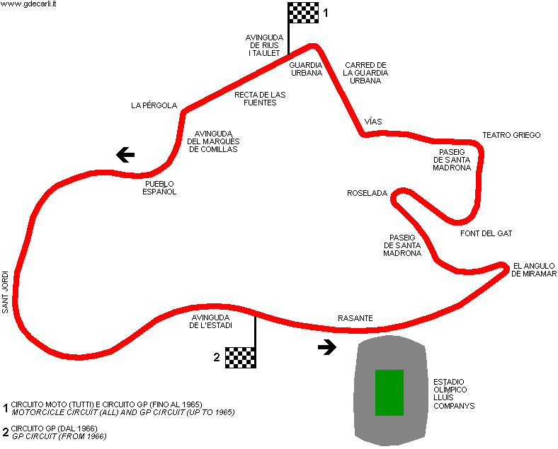
| length | 3790 m | 12434 ft | 2.355 mi | (9) | |
| length | 3791 m | 12438 ft | 2.356 mi | (10) | |
| length | 3791 m | 12438 ft | 2.356 mi | (6) | |
| length | 3740 m | 12270 ft | 2.324 mi | Calculated from aerial photo (*) | (5) |
| Difference in level | 65.42 m | 215 ft | (8) | ||
| Montjuich | |||||
| Description | Note: my map could be approximated in the area of the stadium | ||||
| Years | 1951 | ||||
| Direction | Anticlockwise | ||||
| Proposal |
NO | ||||
| No longer operational | YES | ||||
| Car Circuit | |||||
| Motorbike circuit | YES | ||||
| Type | Street course | ||||
| Inauguration | 1951 | ||||
| Closing | 1951 | ||||
| Last update of this page | May 28th 2007 | ||||
| Info last update | |||||
| Designer | |||||
| Distinctive points | |||||
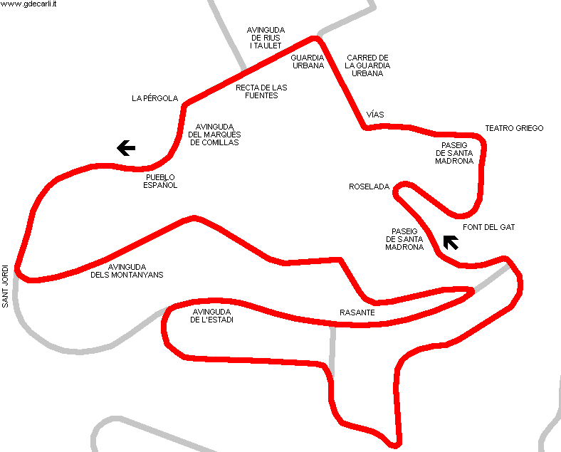
| length | 6033 m | 19793 ft | 3.749 mi | (6) | |
| Montjuich | |||||
| Description | Note: my map could be approximated in the area of the stadium | ||||
| Years | 1952 | ||||
| Direction | Anticlockwise | ||||
| Proposal |
NO | ||||
| No longer operational | YES | ||||
| Car Circuit | |||||
| Motorbike circuit | YES | ||||
| Type | Street course | ||||
| Inauguration | 1952 | ||||
| Closing | 1952 | ||||
| Last update of this page | May 28th 2007 | ||||
| Info last update | |||||
| Designer | |||||
| Distinctive points | |||||
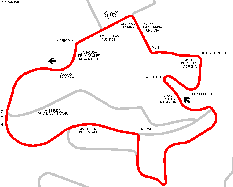
| length | 4205 m | 13796 ft | 2.613 mi | (6) | |
| Montjuich | |||||
| Description | Proposed circuit at Montjuich foot and close to Zona Franca | ||||
| Years | 1980 | ||||
| Direction | |||||
| Proposal |
YES
| ||||
| Proposal not developed | YES | ||||
| Car Circuit | YES | ||||
| Motorbike circuit | |||||
| Type | Permanent | ||||
| Inauguration | |||||
| Closing | |||||
| Last update of this page | January 9th 2006 | ||||
| Info last update | |||||
| Designer | |||||
| Distinctive points | |||||
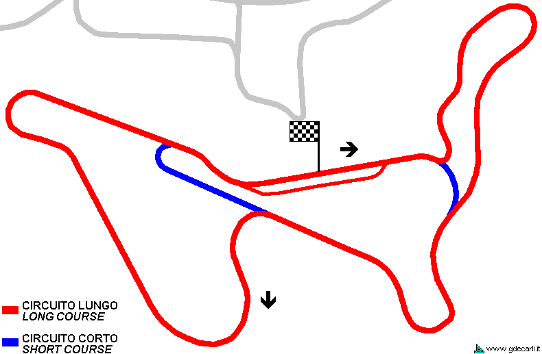
| length | 4100 m | 13451 ft | 2.548 mi | (2) | |
| Montjuich | |||||
| Description | |||||
| Years | 1986 | ||||
| Direction | Anticlockwise | ||||
| Proposal |
YES
| ||||
| Proposal not developed | YES | ||||
| Car Circuit | YES | ||||
| Motorbike circuit | |||||
| Type | Street course | ||||
| Inauguration | |||||
| Closing | |||||
| Last update of this page | March 21st 2009 | ||||
| Info last update | |||||
| Designer | |||||
| Distinctive points | |||||
Montjuich: all layouts

Montjuich: traditional course (1933÷1986)
Due to technical problems, temporarily it’s no longer possible to see the circuits on Google Maps embedded in the current page.
This feature will be restored as soon as I figure out how to do (any help would be appreciated!)
See this track layout with Google Maps - Google Earth
- milermeter.com
(milermeter.com can be used in your browser, without installing anything; Google Earth is a program that must be installed in your computer)
(Map shown here above can show at the same time all eventual layouts drawn. If you want to see only some of them, please go to Google Maps or Google Earth, by clicking on its own link)
Montjuich 1951: motorcycle circuit
Due to technical problems, temporarily it’s no longer possible to see the circuits on Google Maps embedded in the current page.
This feature will be restored as soon as I figure out how to do (any help would be appreciated!)
See this track layout with Google Maps - Google Earth
(milermeter.com can be used in your browser, without installing anything; Google Earth is a program that must be installed in your computer)
(Map shown here above can show at the same time all eventual layouts drawn. If you want to see only some of them, please go to Google Maps or Google Earth, by clicking on its own link)
Montjuich 1952: motorcycle circuit
Due to technical problems, temporarily it’s no longer possible to see the circuits on Google Maps embedded in the current page.
This feature will be restored as soon as I figure out how to do (any help would be appreciated!)
See this track layout with Google Maps - Google Earth
(milermeter.com can be used in your browser, without installing anything; Google Earth is a program that must be installed in your computer)
(Map shown here above can show at the same time all eventual layouts drawn. If you want to see only some of them, please go to Google Maps or Google Earth, by clicking on its own link)
Montjuich, 1980 proposal: long course
Due to technical problems, temporarily it’s no longer possible to see the circuits on Google Maps embedded in the current page.
This feature will be restored as soon as I figure out how to do (any help would be appreciated!)
See this track layout with Google Maps - Google Earth
(milermeter.com can be used in your browser, without installing anything; Google Earth is a program that must be installed in your computer)
(Map shown here above can show at the same time all eventual layouts drawn. If you want to see only some of them, please go to Google Maps or Google Earth, by clicking on its own link)
Montjuich, 1986 proposal
Due to technical problems, temporarily it’s no longer possible to see the circuits on Google Maps embedded in the current page.
This feature will be restored as soon as I figure out how to do (any help would be appreciated!)
See this track layout with Google Maps - Google Earth
(milermeter.com can be used in your browser, without installing anything; Google Earth is a program that must be installed in your computer)
(Map shown here above can show at the same time all eventual layouts drawn. If you want to see only some of them, please go to Google Maps or Google Earth, by clicking on its own link)
| PHOTOS |
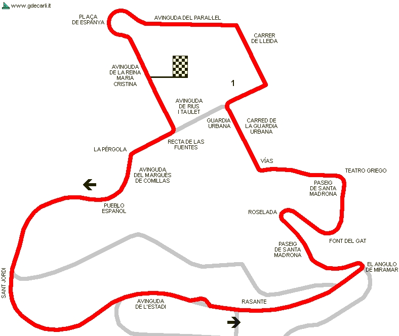
| 1933÷1986 layout. Photos and description in English are by Clyde Berryman, here published with his authorization. Translation in Italian is by Guido de Carli. Position of each photo is shown on Google Maps/Google Earth map (see above) |
| Photos by Clyde P. Berryman - March 2003 |
| Click on thumbnail to open original large photo |
| 1 | 2 | 3 | 4 |
 |  |  |  |
| Looking downhill towards where the start/finish line was located with pit boxes off to the side | Rise along Avinguda de l’Estadi after the start line before a fast slighlty left curve at the crest | Downhill at full bore over the "hump" before massive braking for the Miramar hairpin | The immensely challenging, sharp left-turn hairpin of Miramar where the road also narrows dramatically |
| 5 | 6 | 7 | 8 |
 |  |  |  |
| Exiting Miramar hairpin, an immediate right-hander awaits | Downhill along twisty and narrow Passeig de Santa Madrona | Sharp right hander bend along Passeig de Santa Madrona | Exiting sharp right-hander and proceeding downhill along Passeig de Santa Madrona to the next left turn |
| 9 | 10 | 11 | 12 |
 |  |  |  |
| Scenic and narrow Passeig de Santa Madrona left curve | Curving, downhill leg along Passeig de Santa Madrona | Down and hard left at the corner where the Museu d’Arqueologia de Catalunya [Archeological Museum of Catalonia] (behind trees on left) is located | Passing between Museu d’Arqueologia de Catalunya [Archeological Museum of Catalonia] (left) and the Teatre Lliure [theater] (right) |
| 13 | 14 | 15 | 16 |
 |  |  |  |
| The end of Passeig de Santa Madrona leading to Palau d´Alfons XIII | Right turn onto Av. Tecnica (Carrer de la Guardia Urbana) | Sharp left from turn from Av. Tecnica (Carrer de la Guardia Urbana) onto Avinguda de Rius i Taulet | Looking down Avinguda de Rius i Taulet |
| 17 | 18 | 19 | 20 |
 |  |  |  |
| Beginning of Avinguda del Marquès de Comillas | ’S’ bends along Avinguda del Marquès de Comillas | Along Avinguda del Marquès de Comillas | Rise to left-hand bend on Avinguda del Marquès de Comillas leading to Plaza Sant Jordi |
| 21 | 22 | 23 | 24 |
 |  |  |  |
| Plaza Sant Jordi | Entering fast left-hand sweeper towards Avinguda del Estadi | Exititing fast left-hand sweeper towards Avinguda del Estadi | Avinguda del Estadi - the rise approaching Piscines Bernat Picornell off the right |
| Updates | |||||||
| Date | Track layout | Years | Description by | Map by | Thanks to | Note | |
| January 17th 2010 | 1933÷1986 | Guido de Carli | Clyde P. Berryman | Update | Photos (on this site) | ||
| March 21st 2009 | Guido de Carli | Guido de Carli | Update | Description with map | |||
| October 22nd 2008 | 1933÷1986 | Guido de Carli | Vasco | Vasco | Update | Map | |
| December 18th 2007 | Lorenzo Tommasi | Update | Description | ||||
| May 28th 2007 | Guido de Carli | Update | Description | ||||
| January 9th 2006 | 1980 | Guido de Carli | Rafa Reyna | Update | Description | ||
| August 12th 2005 | Guido de Carli | Update | Description | ||||
| February 15th 2005 | Guido de Carli | New | Photos (link) | ||||
| September 23rd 2003 | Guido de Carli | Update | Description | ||||
| July 6th 2003 | Guido de Carli | New | Description | ||||
| Not all eventual updates issued in last years are already visible in this list | |||||||
Webmaster:
Guido de Carli

(Italiano - English - Español)
HOME PAGE