 Visualizza questa pagina in Italiano
 HOME PAGE
|
Visualizza questa pagina in Italiano
|
HOME PAGE
|
Legend and translations |
| RUS - RUSSIA | |||||||||||||||||||||
| MOSKVA (1982) / МОСКВА (1982) | |||||||||||||||||||||
| Not to be confused with | Luzhniki / Лужники - Moscow Raceway - Moscow Ring - Moskva (14 km) - Moskva (2005÷2006) / Москва (2005÷2006) - Moskva (2520 m) / Москва (2520 м) - Moskva, Kremlin / Москва, Кремль - Vorobyovy Gory / Sparrow Hills / Воробъевы Горы | ||||||||||||||||||||
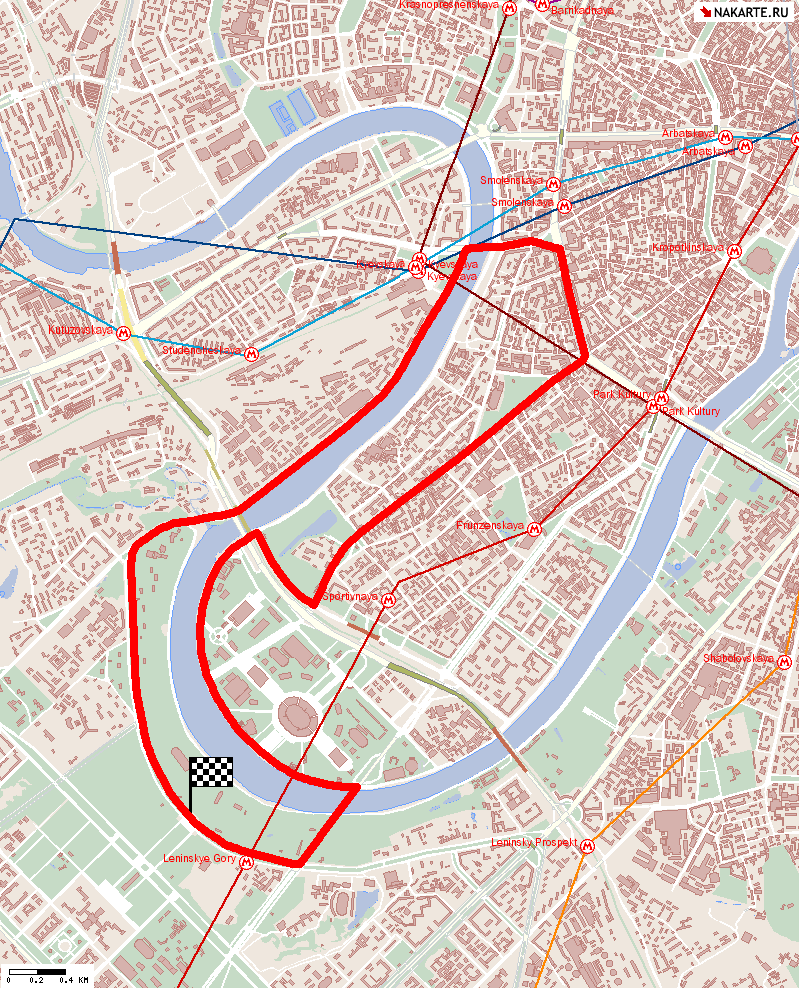
| Description | Since 1980 there were rumors about a F.1 GP at Moscow, on a street track. There had been many proposals; the one shown on my map is dated June 1982 and it is about a possible GP to be raced in July or August 1983. Initial proposal was about a track approx 4 km long, but Mr.Ecclestone suggest to lengthen it up to 5-6 km, in order to have more room for sponsors banners. Map shown here is much longer, but I don’t know what it shows. Some weeks later a date was decided for this GP (August 22nd 1983), but in September 1982 this GP was canceled. However, in following years there had been some more rumors about a Moscow GP, even if it was never raced. | ||||||||||||||||||||
| Location | Moskva / Москва́ - Moskva - Tsentralny / Central | ||||||||||||||||||||
| Location | near Moscow University; it has some section in common with Luzhniki (1961-1965) and Vorobyovy Gory | ||||||||||||||||||||
| Latitude - Longitude | + 55°43'20" + 37°33'16" 55.722222 37.554444 | ||||||||||||||||||||
| UTM Coordinates | X = 409201.773 - Y = 6176110.902 - Zone 37U | ||||||||||||||||||||
| Aerial photo / Map (*) |  Google Maps - Bing Maps - Flash Earth - New Kosmosnimki - Yandex Google Maps - Bing Maps - Flash Earth - New Kosmosnimki - Yandex | ||||||||||||||||||||
| Altitude AMSL | 121 m - 397 ft | ||||||||||||||||||||
| Inauguration | |||||||||||||||||||||
| Closing | |||||||||||||||||||||
| Designer | |||||||||||||||||||||
| Sources and links (Translation) (**) |
| ||||||||||||||||||||
| Moskva (1982) / Москва (1982) | |||||
| Description | |||||
| Years | 1982 | ||||
| Direction | |||||
 Proposal Proposal |
YES
| ||||
| Proposal not developed | YES | ||||
| Car Circuit | YES | ||||
| Motorbike circuit | |||||
| Type | Street course | ||||
| Inauguration | |||||
| Closing | |||||
| Last update of this page | December 17th 2010 | ||||
| Info last update | September 1982 | ||||
| Designer | |||||
| Distinctive points | |||||
| length (approx) | 4000 m | 13123 ft | 2.486 mi | Original proposal | |
| length | 14104 m | 46273 ft | 8.764 mi | Calculated from aerial photo (*) | (3) |
Comparison between Moscow circuits: Luzhniki, 1982 proposal, Kremlin Proposal and Vorobyovy Gory
Due to technical problems, temporarily it’s no longer possible to see the circuits on Google Maps embedded in the current page.
This feature will be restored as soon as I figure out how to do (any help would be appreciated!)
See this track layout with Google Maps - Google Earth
(milermeter.com can be used in your browser, without installing anything; Google Earth is a program that must be installed in your computer)
(Map shown here above can show at the same time all eventual layouts drawn. If you want to see only some of them, please go to Google Maps or Google Earth, by clicking on its own link)
Moskva (1982)
Due to technical problems, temporarily it’s no longer possible to see the circuits on Google Maps embedded in the current page.
This feature will be restored as soon as I figure out how to do (any help would be appreciated!)
See this track layout with Google Maps - Google Earth
- milermeter.com
(milermeter.com can be used in your browser, without installing anything; Google Earth is a program that must be installed in your computer)
(Map shown here above can show at the same time all eventual layouts drawn. If you want to see only some of them, please go to Google Maps or Google Earth, by clicking on its own link)
| Updates | |||||||
| Date | Track layout | Years | Description by | Map by | Thanks to | Note | |
| December 17th 2010 | 1982 | Guido de Carli | Update | Description | |||
| October 20th 2003 | 1982 | Guido de Carli | Guido de Carli | New | Description with map | ||
| Not all eventual updates issued in last years are already visible in this list | |||||||
Webmaster:
Guido de Carli

(Italiano - English - Español)
HOME PAGE