 Visualizza questa pagina in Italiano
 HOME PAGE
|
Visualizza questa pagina in Italiano
|
HOME PAGE
|
Legend and translations |
| ESP - SPAIN | |||||||||||||||||||||
| VISTAHERMOSA | |||||||||||||||||||||
| Description | Circuit used for 1stPremio «Escuderia Alicante» on February 15th 1970 | ||||||||||||||||||||
| Location | Vistahermosa, Alicante A - Alicante / Alacant - Comunitat Valenciana | ||||||||||||||||||||
| Location | |||||||||||||||||||||
| Latitude - Longitude | + 38°21'32" - 0°27'38" 38.358889 -0.460556 | ||||||||||||||||||||
| UTM Coordinates | X = 721882.314 - Y = 4248688.321 - Zone 30S | ||||||||||||||||||||
| Aerial photo / Map (*) |  Google Maps - Bing Maps - Flash Earth - Visor SIGPAC Google Maps - Bing Maps - Flash Earth - Visor SIGPAC | ||||||||||||||||||||
| Altitude AMSL | 1 m - 3 ft | ||||||||||||||||||||
| Inauguration | February 15th 1970 | ||||||||||||||||||||
| Closing | February 15th 1970 | ||||||||||||||||||||
| Designer | |||||||||||||||||||||
| Sources and links (Translation) (**) |
| ||||||||||||||||||||
| Vistahermosa | |||||
| Description | Track layout on aerial photo could be approximated | ||||
| Years | 1970 | ||||
| Direction | |||||
 Proposal Proposal |
NO | ||||
| No longer operational | YES | ||||
| Car Circuit | YES | ||||
| Motorbike circuit | |||||
| Type | Street course | ||||
| Inauguration | February 15th 1970 | ||||
| Closing | February 15th 1970 | ||||
| Last update of this page | April 10th 2013 | ||||
| Info last update | |||||
| Designer | |||||
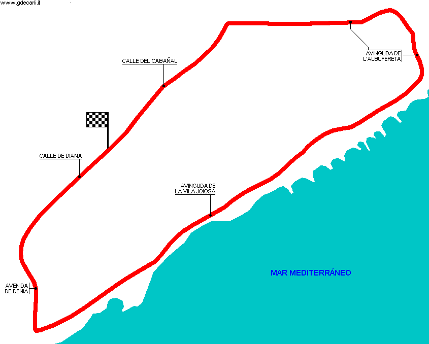
| Distinctive points | Calle de Diana - Avenida de Denia - Avinguda de la Vila Joiosa - Avinguda de l’Albufereta - Calle del Cabañal | ||||
| length | 6350 m | 20833 ft | 3.946 mi | (4) | |
| length | 6350 m | 20833 ft | 3.946 mi | (2) | |
| length | 6207 m | 20363 ft | 3.857 mi | Calculated from aerial photo (*) | (3) |
Vistahermosa
Due to technical problems, temporarily it’s no longer possible to see the circuits on Google Maps embedded in the current page.
This feature will be restored as soon as I figure out how to do (any help would be appreciated!)
See this track layout with Google Maps - Google Earth
- milermeter.com
(milermeter.com can be used in your browser, without installing anything; Google Earth is a program that must be installed in your computer)
(Map shown here above can show at the same time all eventual layouts drawn. If you want to see only some of them, please go to Google Maps or Google Earth, by clicking on its own link)
| Updates | |||||||
| Date | Track layout | Years | Description by | Map by | Thanks to | Note | |
| October 20th 2019 | 1970 | Guido de Carli | Update | Description | |||
| April 11th 2013 | 1970 | Guido de Carli | Guido de Carli | Frank de Jong | Update | Description with map | |
| May 19th 2007 | 1970 | Guido de Carli | Guido de Carli | Update | Description with map | ||
| March 15th 2005 | 1970 | Guido de Carli | Guido de Carli | Update | Description with map | ||
| March 1st 2005 | 1970 | Guido de Carli | New | Description without map | |||
| Not all eventual updates issued in last years are already visible in this list | |||||||
Webmaster:
Guido de Carli

(Italiano - English - Español)
HOME PAGE