 Visualizza questa pagina in Italiano
 HOME PAGE
|
Visualizza questa pagina in Italiano
|
HOME PAGE
|
Legend and translations |
| FIN - FINLAND | |||||||||||||||||||||||||||||||||
| KEIMOLA / KäINBY | |||||||||||||||||||||||||||||||||
| SORRY, SOME DATA ARE NOT TRANSLATED YET | |||||||||||||||||||||||||||||||||
| Description | First permanent circuit ever built in Finland. Its construction begun in 1965 on a level area on the initiative of Mr. Lincoln, a former driver, wood exporter and Rindt’s father-in-law. The circuit was opened in 1966, even if it was still under construction. In 1970 - still unfinished and heavvily indebted - it was sold to Mr. Wihuri, that decided to finish it by adding to bankings inspired to Monza Curve Alta Velocità. I don’t think they were never built. The circuit was closed in 1978. | ||||||||||||||||||||||||||||||||
| Location | Vantaa / Vanda - Uusimaa / Nyland - Etelä-Suomen lääni / Södra Finlands län | ||||||||||||||||||||||||||||||||
| Location | 18 km - 11.2 from Helsinki, on the road to Hämeenlinna Keimolan Moottoristadion Keimola Racing Oy SF-01730 VANTAA 2 (SUOMI FINLAND) | ||||||||||||||||||||||||||||||||
| Latitude - Longitude | + 60°19'04" + 24°49'57" 60.317778 24.8325 | ||||||||||||||||||||||||||||||||
| UTM Coordinates | X = 380277.746 - Y = 6688770.015 - Zone 35V | ||||||||||||||||||||||||||||||||
| Aerial photo / Map (*) |  Google Maps - Bing Maps - Flash Earth - New Kosmosnimki - Eniro Google Maps - Bing Maps - Flash Earth - New Kosmosnimki - Eniro | ||||||||||||||||||||||||||||||||
| Altitude AMSL | 69 m - 226 ft | ||||||||||||||||||||||||||||||||
| Inauguration | 1966 | ||||||||||||||||||||||||||||||||
| Closing | 1978 | ||||||||||||||||||||||||||||||||
| Designer | |||||||||||||||||||||||||||||||||
| Sources and links (Translation) (**) |
| ||||||||||||||||||||||||||||||||
| Keimolan Moottoristadion | |||||
| Description | |||||
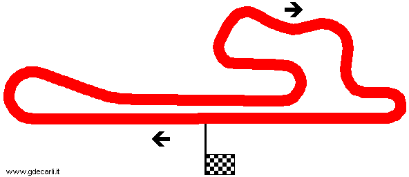
| Years | 1966÷1978 | ||||
| Direction |  Clockwise Clockwise | ||||
 Proposal Proposal |
NO | ||||
| No longer operational | YES | ||||
| Car Circuit | YES | ||||
| Motorbike circuit | |||||
| Type | |||||
| Inauguration | 1966 | ||||
| Closing | 1978 | ||||
| Last update of this page | August 9th 2002 | ||||
| Info last update | |||||
| Designer | |||||
| Distinctive points | |||||
| length | 3300 m | 10827 ft | 2.051 mi | (1) | |
| Width | 9 m | 30 ft | (1) | ||
Keimolan Moottoristadion
| Updates | |||||||
| Date | Track layout | Years | Description by | Map by | Thanks to | Note | |
| October 2nd 2008 | Guido de Carli | Update | Description | ||||
| December 10th 2005 | Keimolan Moottoristadion | 1966÷1978 | Guido de Carli | Update | Description | ||
| September 1st 2005 | Keimolan Moottoristadion | 1966÷1978 | Guido de Carli | Update | Description | ||
| March 21st 2004 | Keimolan Moottoristadion | 1966÷1978 | Guido de Carli | New | Photos (link) | ||
| March 20th 2004 | Keimolan Moottoristadion | 1966÷1978 | Guido de Carli | Guido de Carli | New | Description with map | |
| July 6th 2003 | Keimolan Moottoristadion | 1966÷1978 | Guido de Carli | Update | Description | ||
| August 9th 2002 | Keimolan Moottoristadion | 1966÷1978 | Guido de Carli | Update | Description | ||
| Not all eventual updates issued in last years are already visible in this list | |||||||
Webmaster:
Guido de Carli

(Italiano - English - Español)
HOME PAGE