 Visualizza questa pagina in Italiano
 HOME PAGE
|
Visualizza questa pagina in Italiano
|
HOME PAGE
|
Legend and translations |
| ITA - ITALY | |||||||||
| VIGEVANO (KART) | |||||||||
| SORRY, SOME DATA ARE NOT TRANSLATED YET | |||||||||
| Not to be confused with | Vigevano | ||||||||
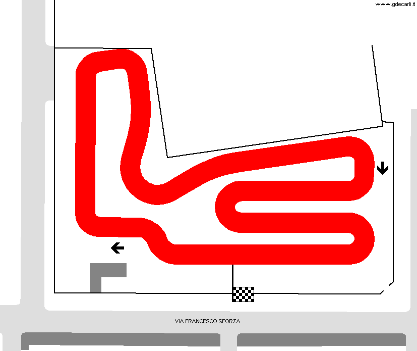
| Description | Street kart circuit used for Lombardia Regional Championship on June 11th 1989. I don’t know if it was used more times. | ||||||||
| Location | Vigevano PV - Pavia - Lombardia | ||||||||
| Location | In a car parking between via Francesco II Sforza and Via Bramante, Vigevano | ||||||||
| Latitude - Longitude | + 45°18'58" + 8°50'58" 45.316111 8.849444 | ||||||||
| UTM Coordinates | X = 488199.313 - Y = 5018078.325 - Zone 32T | ||||||||
| Aerial photo / Map (*) |  Google Maps - Bing Maps - Flash Earth - Portale Cartografico Nazionale - Visual Pagine Gialle Google Maps - Bing Maps - Flash Earth - Portale Cartografico Nazionale - Visual Pagine Gialle | ||||||||
| Altitude AMSL | 104 m - 341 ft | ||||||||
| Inauguration | |||||||||
| Closing | |||||||||
| Designer | |||||||||
| Sources and links (Translation) (**) |
| ||||||||
| Vigevano (kart) | |||||
| Description | |||||
| Years | 1989 | ||||
| Direction |  Clockwise Clockwise | ||||
 Proposal Proposal |
NO | ||||
| No longer operational | |||||
| Car Circuit | |||||
| Motorbike circuit | |||||
| Type | Kart track | ||||
| Inauguration | |||||
| Closing | |||||
| Last update of this page | November 1st 2005 | ||||
| Info last update | June 1989 | ||||
| Designer | |||||
| Distinctive points | |||||
| length | 600 m | 1969 ft | 0.373 mi | (2) | |
Vigevano (kart)
Webmaster:
Guido de Carli

(Italiano - English - Español)
HOME PAGE