 Visualizza questa pagina in Italiano
 HOME PAGE
|
Visualizza questa pagina in Italiano
|
HOME PAGE
|
Legend and translations |
| ZIM - ZIMBABWE | |||||||||||||||||||||
| BELVEDERE AIRFIELD | |||||||||||||||||||||
| Description | Not to be confused with Belvedere street circuit, few meters far. The circuit was used surely for Rhodesian Grand Prix on August 14th 1960, but I don’t know if this was its first race or not. | ||||||||||||||||||||
| Location | Salisbury / Harare - Harare | ||||||||||||||||||||
| Location | Former Belvedere airfield, North West of Salisbury (renamed Harare on April 18th 1982). Now this area is completely built over | ||||||||||||||||||||
| Latitude - Longitude (approx) | - 17°49'44" + 31°00'31" (approx) -17.828889 31.008611 (approx) | ||||||||||||||||||||
| UTM Coordinates (approx) | X = 288949.192 - Y = 8027622.075 - Zone 36K (approx) | ||||||||||||||||||||
| Aerial photo / Map (*) |  Google Maps - Bing Maps - Flash Earth Google Maps - Bing Maps - Flash Earth | ||||||||||||||||||||
| Altitude AMSL (approx) | 1460 m - 4790 ft (approx) | ||||||||||||||||||||
| Inauguration | August 14th 1960 | ||||||||||||||||||||
| Closing | 1974 | ||||||||||||||||||||
| Designer | |||||||||||||||||||||
| Sources and links (Translation) (**) |
| ||||||||||||||||||||
| Belvedere Airfield | |||||
| Description | |||||
| Years | 1960÷1974 | ||||
| Direction |  Clockwise Clockwise | ||||
 Proposal Proposal |
NO | ||||
| No longer operational | YES | ||||
| Car Circuit | YES | ||||
| Motorbike circuit | |||||
| Type | Airfield course | ||||
| Inauguration | August 14th 1960 | ||||
| Closing | 1974 | ||||
| Last update of this page | February 23rd 2009 | ||||
| Info last update | |||||
| Designer | |||||
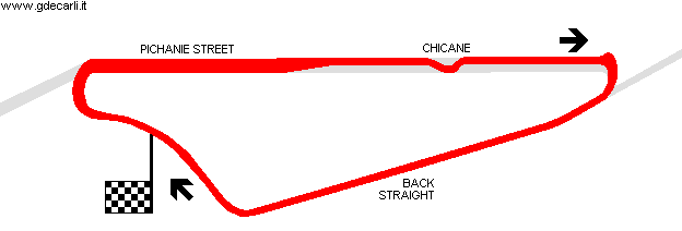
| Distinctive points | Pichanie Street - Back Straight | ||||
| length | 3219 m | 10560 ft | 2 mi | (5) | |
Belvedere Airfield
| Updates | |||||||
| Date | Track layout | Years | Description by | Map by | Thanks to | Note | |
| February 23rd 2009 | 1960÷1974 | Guido de Carli | Roelard Smit | Update | Description | ||
| February 22nd 2009 | 1960÷1974 | Guido de Carli | Guido de Carli | Bob Simbel | Update | Description with map | |
| October 4th 2007 | 1960÷1974 | Guido de Carli | Guido de Carli | Update | Description with map | ||
| April 20th 2007 | 1960÷1974 | Guido de Carli | New | Description | |||
| Not all eventual updates issued in last years are already visible in this list | |||||||
Webmaster:
Guido de Carli

(Italiano - English - Español)
HOME PAGE