 Visualizza questa pagina in Italiano
 HOME PAGE
|
Visualizza questa pagina in Italiano
|
HOME PAGE
|
Legend and translations |
| ZIM - ZIMBABWE | |||||||||||||
| KUMALO, MCNEILLIE | |||||||||||||
| Description | I don’t know when this track was first used, but I know that on October 25th 1959 it hosted National Motor Race Meeting | ||||||||||||
| Location | Kumalo, Bulawayo - Matabeleland North | ||||||||||||
| Location | Bulawayo Estern suburb | ||||||||||||
| Latitude - Longitude | - 20°08'13" + 28°36'31" -20.136944 28.608611 | ||||||||||||
| UTM Coordinates | X = 668140.093 - Y = 7772551.628 - Zone 35K | ||||||||||||
| Aerial photo / Map (*) |  Google Maps - Bing Maps - Flash Earth Google Maps - Bing Maps - Flash Earth | ||||||||||||
| Altitude AMSL | 1334 m - 4377 ft | ||||||||||||
| Inauguration | |||||||||||||
| Closing | 1970 | ||||||||||||
| Designer | |||||||||||||
| Sources and links (Translation) (**) |
| ||||||||||||
| James McNeillie Circuit | |||||
| Description | |||||
| Years | ...÷1970 | ||||
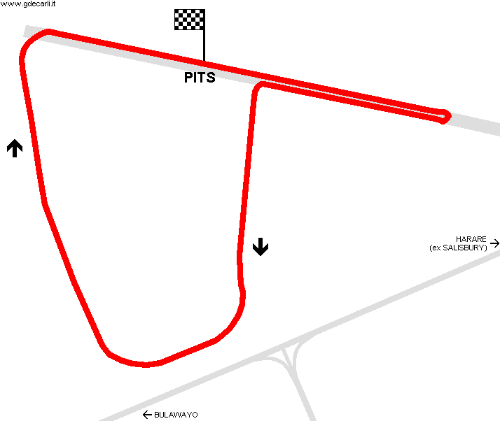
| Direction |  Clockwise Clockwise | ||||
 Proposal Proposal |
NO | ||||
| No longer operational | YES | ||||
| Car Circuit | YES | ||||
| Motorbike circuit | |||||
| Type | Airfield course | ||||
| Inauguration | |||||
| Closing | 1970 | ||||
| Last update of this page | April 20th 2007 | ||||
| Info last update | |||||
| Designer | |||||
| Distinctive points | |||||
| length | 3444 m | 11299 ft | 2.14 mi | (3) | |
Kumalo: James McNeillie Circuit
Due to technical problems, temporarily it’s no longer possible to see the circuits on Google Maps embedded in the current page.
This feature will be restored as soon as I figure out how to do (any help would be appreciated!)
See this track layout with Google Maps - Google Earth
(milermeter.com can be used in your browser, without installing anything; Google Earth is a program that must be installed in your computer)
(Map shown here above can show at the same time all eventual layouts drawn. If you want to see only some of them, please go to Google Maps or Google Earth, by clicking on its own link)
| Updates | |||||||
| Date | Track layout | Years | Description by | Map by | Thanks to | Note | |
| October 4th 2007 | James McNeillie Circuit | ...÷1970 | Guido de Carli | Guido de Carli | Update | Description with map | |
| April 20th 2007 | Guido de Carli | New | Description | ||||
| Not all eventual updates issued in last years are already visible in this list | |||||||
Webmaster:
Guido de Carli

(Italiano - English - Español)
HOME PAGE