 Visualizza questa pagina in Italiano
 HOME PAGE
|
Visualizza questa pagina in Italiano
|
HOME PAGE
|
Legend and translations |
| CZE - CZECH REPUBLIC | |||||||||
| KLATOVY | |||||||||
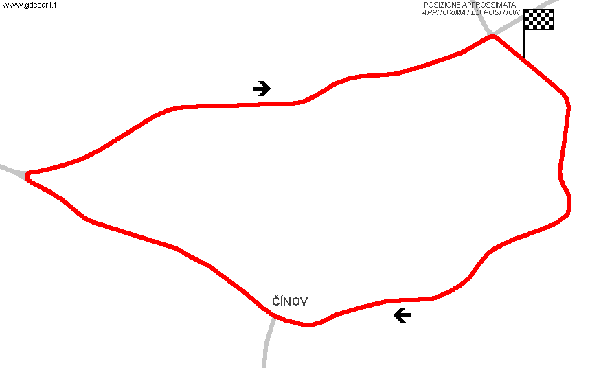
| Description | Circuit used for event of CzechoSlovakian F.3, sport and touring car championships between mid 1960s and mid 1980s (or in a shorter period inside this time slice). It should have been a combination of city streets and public roads. Also used as " Činovský okruh" for Special Stage 1 of international Rally Šumava nowadays. there were plans to turn this circuit into a permanent one, but they had not enough money and determination, so it was never developed | ||||||||
| Location | Klatovy P - Plzeňský kraj - Jihozápad | ||||||||
| Location | East of Klatovy, through Čínov village | ||||||||
| Latitude - Longitude | + 49°23'44" + 13°19'48" 49.395556 13.33 | ||||||||
| UTM Coordinates | X = 378824.793 - Y = 5472770.299 - Zone 33U | ||||||||
| Aerial photo / Map (*) |  Google Maps - Bing Maps - Flash Earth - Mapy.cz Google Maps - Bing Maps - Flash Earth - Mapy.cz | ||||||||
| Altitude AMSL | 431 m - 1414 ft | ||||||||
| Inauguration | |||||||||
| Closing | |||||||||
| Designer | |||||||||
| Sources and links (Translation) (**) |
| ||||||||
| Klatovy | |||||
| Description | Start/finish location shown on my map is approximated | ||||
| Years | |||||
| Direction |  Clockwise Clockwise | ||||
 Proposal Proposal |
NO | ||||
| No longer operational | YES | ||||
| Car Circuit | YES | ||||
| Motorbike circuit | |||||
| Type | Road course | ||||
| Inauguration | |||||
| Closing | |||||
| Last update of this page | June 2nd 2008 | ||||
| Info last update | |||||
| Designer | |||||
| Distinctive points | |||||
| length | 3919 m | 12857 ft | 2.435 mi | Calculated from aerial photo (*) | (2) |
Klatovy
See this track layout with milermeter.com
(milermeter.com can be used in your browser, without installing anything; Google Earth is a program that must be installed in your computer)
| Updates | |||||||
| Date | Track layout | Years | Description by | Map by | Thanks to | Note | |
| June 2nd 2008 | Guido de Carli | Guido de Carli | David Griac (jpm) | Update | Description with map | ||
| March 12th 2008 | Guido de Carli | David Griac (jpm) | Update | Description without map | |||
| February 10th 2008 | Guido de Carli | David Griac (jpm) | New | Description without map | |||
| Not all eventual updates issued in last years are already visible in this list | |||||||
Webmaster:
Guido de Carli

(Italiano - English - Español)
HOME PAGE