 Visualizza questa pagina in Italiano
 HOME PAGE
|
Visualizza questa pagina in Italiano
|
HOME PAGE
|
Legend and translations |
| CZE - CZECH REPUBLIC | |||||||||||||||||||||||||||||||||||||||||||||
| TĚRLICKO | |||||||||||||||||||||||||||||||||||||||||||||
| Description | Important circuit that hosted event of CzechoSlovakian F.3, sport and touring car championships and for Eastern European Peace & Friendship Cup races. On aerial photos you can see two chicanes, but I don’t know when they have been built. In 2008 a third one was used, not shown in aerial photos taken in 2004. | ||||||||||||||||||||||||||||||||||||||||||||
| Location | Těrlicko T - Moravskoslezský kraj - Moravskoslezsko | ||||||||||||||||||||||||||||||||||||||||||||
| Location | Approx 16 km - 10 m iSOuth East of Ostrava, not far from Havířov and Vítkovice | ||||||||||||||||||||||||||||||||||||||||||||
| Latitude - Longitude | + 49°45'49" + 18°28'43" 49.763611 18.478611 | ||||||||||||||||||||||||||||||||||||||||||||
| UTM Coordinates | X = 318424.61 - Y = 5515399.259 - Zone 34U | ||||||||||||||||||||||||||||||||||||||||||||
| Aerial photo / Map (*) |  Google Maps - Bing Maps - Flash Earth - Mapy.cz Google Maps - Bing Maps - Flash Earth - Mapy.cz | ||||||||||||||||||||||||||||||||||||||||||||
| Altitude AMSL | 330 m - 1083 ft | ||||||||||||||||||||||||||||||||||||||||||||
| Inauguration | 1965 | ||||||||||||||||||||||||||||||||||||||||||||
| Closing | |||||||||||||||||||||||||||||||||||||||||||||
| Designer | |||||||||||||||||||||||||||||||||||||||||||||
| Sources and links (Translation) (**) |
| ||||||||||||||||||||||||||||||||||||||||||||
| Těrlicko | |||||
| Description | |||||
| Years | 1965÷1982 | ||||
| Direction |  Anticlockwise Anticlockwise | ||||
 Proposal Proposal |
NO | ||||
| No longer operational | YES | ||||
| Car Circuit | YES | ||||
| Motorbike circuit | |||||
| Type | Road course | ||||
| Inauguration | 1965 | ||||
| Closing | 1982 | ||||
| Last update of this page | February 28th 2008 | ||||
| Info last update | |||||
| Designer | |||||
| Distinctive points | Karvinská - Padlých hr dinú - Ostravská | ||||
| length | 6000 m | 19685 ft | 3.728 mi | (1) | |
| length | 6000 m | 19685 ft | 3.728 mi | (6) | |
| length | 6093 m | 19990 ft | 3.786 mi | Calculated from aerial photo (*) | (4) |
| Difference in level | 65 m | 213 ft | (1) | ||
| Těrlicko | |||||
| Description | Circuit was unchanged, but direction was changed in order to have better run off areas | ||||
| Years | 1983÷1990 | ||||
| Direction |  Clockwise Clockwise | ||||
| Proposal |
NO | ||||
| No longer operational | YES | ||||
| Car Circuit | YES | ||||
| Motorbike circuit | |||||
| Type | Road course | ||||
| Inauguration | 1983 | ||||
| Closing | 1990 | ||||
| Last update of this page | February 28th 2008 | ||||
| Info last update | |||||
| Designer | |||||
| Distinctive points | Karvinská - Ostravská - Padlých hr dinú | ||||
| length | 6000 m | 19685 ft | 3.728 mi | (1) | |
| length | 6093 m | 19990 ft | 3.786 mi | Calculated from aerial photo (*) | (4) |
| Difference in level | 65 m | 213 ft | (1) | ||
| Těrlicko | |||||
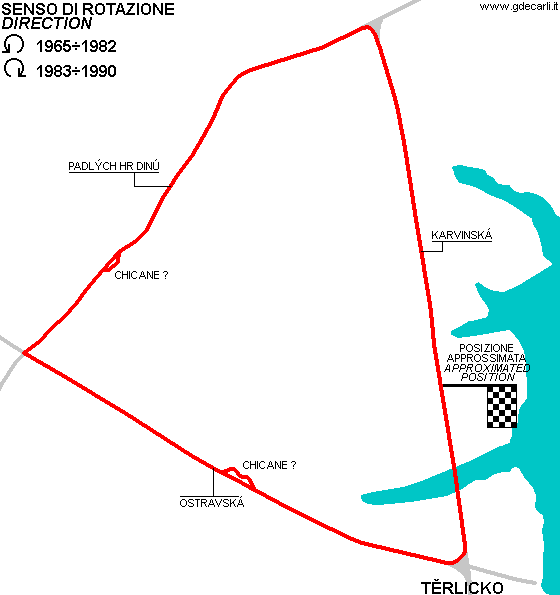
| Description | Track was used again in 2008 (or before). Now it has three chicanes (the third one is a bus stop chicane nuilt with haybales), while second bend was modified as a roundabout was built there. The race track was newly covered with asphalt in May 2008. | ||||
| Years | 2008?÷2009 | ||||
| Direction | Clockwise | ||||
| Proposal |
NO | ||||
| No longer operational | YES | ||||
| Car Circuit | |||||
| Motorbike circuit | YES | ||||
| Type | Road course | ||||
| Inauguration | |||||
| Closing | 2009 | ||||
| Last update of this page | December 27th 2009 | ||||
| Info last update | |||||
| Designer | |||||
| Distinctive points | Karvinská - Ostravská - Padlých hr dinú | ||||
| length | 6100 m | 20013 ft | 3.79 mi | (11) | |
| length | 6259 m | 20536 ft | 3.89 mi | Calculated from aerial photo (*) | (5) |
| Difference in level | 65 m | 213 ft | (11) | ||
| Těrlicko | |||||
| Description | Compared to the previous layout, a new chicane was added. I have no more details | ||||
| Years | 2010 | ||||
| Direction | Clockwise | ||||
| Proposal |
NO | ||||
| No longer operational | YES | ||||
| Car Circuit | |||||
| Motorbike circuit | YES | ||||
| Type | Road course | ||||
| Inauguration | August 2010 | ||||
| Closing | August 2010 | ||||
| Last update of this page | September 9th 2011 | ||||
| Info last update | |||||
| Designer | |||||
| Distinctive points | |||||
| Těrlicko | |||||
| Description | Compared to the previous layout, the circuit is slower because of a new layou of the last corner and some minor changes | ||||
| Years | 2011÷... | ||||
| Direction | Clockwise | ||||
| Proposal |
NO | ||||
| No longer operational | |||||
| Car Circuit | |||||
| Motorbike circuit | YES | ||||
| Type | Road course | ||||
| Inauguration | August 26th 2011 | ||||
| Closing | |||||
| Last update of this page | September 9th 2011 | ||||
| Info last update | |||||
| Designer | |||||
| Distinctive points | |||||
Těrlicko: comparison between different layouts
Due to technical problems, temporarily it’s no longer possible to see the circuits on Google Maps embedded in the current page.
This feature will be restored as soon as I figure out how to do (any help would be appreciated!)
See this track layout with Google Maps - Google Earth
(milermeter.com can be used in your browser, without installing anything; Google Earth is a program that must be installed in your computer)
(Map shown here above can show at the same time all eventual layouts drawn. If you want to see only some of them, please go to Google Maps or Google Earth, by clicking on its own link)
Těrlicko: 1965÷1982 anticlockwise
Due to technical problems, temporarily it’s no longer possible to see the circuits on Google Maps embedded in the current page.
This feature will be restored as soon as I figure out how to do (any help would be appreciated!)
See this track layout with Google Maps - Google Earth
- milermeter.com
(milermeter.com can be used in your browser, without installing anything; Google Earth is a program that must be installed in your computer)
(Map shown here above can show at the same time all eventual layouts drawn. If you want to see only some of them, please go to Google Maps or Google Earth, by clicking on its own link)
Těrlicko: 1983÷1990 clockwise
Due to technical problems, temporarily it’s no longer possible to see the circuits on Google Maps embedded in the current page.
This feature will be restored as soon as I figure out how to do (any help would be appreciated!)
See this track layout with Google Maps - Google Earth
- milermeter.com
(milermeter.com can be used in your browser, without installing anything; Google Earth is a program that must be installed in your computer)
(Map shown here above can show at the same time all eventual layouts drawn. If you want to see only some of them, please go to Google Maps or Google Earth, by clicking on its own link)
Těrlicko 2008÷...
Due to technical problems, temporarily it’s no longer possible to see the circuits on Google Maps embedded in the current page.
This feature will be restored as soon as I figure out how to do (any help would be appreciated!)
See this track layout with Google Maps - Google Earth
- milermeter.com
(milermeter.com can be used in your browser, without installing anything; Google Earth is a program that must be installed in your computer)
(Map shown here above can show at the same time all eventual layouts drawn. If you want to see only some of them, please go to Google Maps or Google Earth, by clicking on its own link)
| Updates | |||||||
| Date | Track layout | Years | Description by | Map by | Thanks to | Note | |
| September 9th 2011 | Guido de Carli | Sal Chiappetta "Muzza" | Update | Description | |||
| December 27th 2009 | 2008?÷2009 | Guido de Carli | Quintin03 | Quintin03 | Update | Description with map | |
| December 22nd 2009 | Guido de Carli | Quintin03 | Update | Description | |||
| October 9th 2009 | 2008?÷2009 | Guido de Carli | Update | Description | |||
| October 8th 2009 | 2008?÷2009 | Guido de Carli | David Griac (jpm) | Update | Description | ||
| February 28th 2008 | Guido de Carli | Guido de Carli | David Griac (jpm) | New | Description with map | ||
| Not all eventual updates issued in last years are already visible in this list | |||||||
Webmaster:
Guido de Carli

(Italiano - English - Español)
HOME PAGE