 Visualizza questa pagina in Italiano
 HOME PAGE
|
Visualizza questa pagina in Italiano
|
HOME PAGE
|
Legend and translations |
| ITA - ITALY | |||||
| MODENA (1951) | |||||
| Not to be confused with | Modena (1927÷1928) - Modena (1933÷1947) - Modena, Aerautodromo - Modena, Bruciata - Modena, Marzaglia, Cittanova - Modena, Navicello | ||||
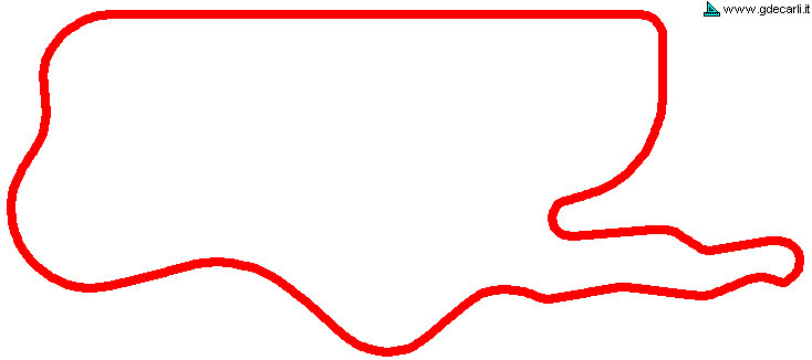
| Description | This circuit was proposed at 1500cc Formula 1 time, probably in 1951. On this circuit, F.1 top speed would have been 235 km/h - 146 mph and average speed 150-160 km/h - 93-99 mph. I have no more info. Not to be confused with Aerautodromo, used in the same period | ||||
| Location | Modena MO - Modena - Emilia Romagna | ||||
| Location | |||||
| Latitude - Longitude (approx) | + 44°39'00" + 10°56'00" (approx) 44.65 10.933333 (approx) | ||||
| UTM Coordinates (approx) | X = 653301.434 - Y = 4945889.057 - Zone 32T (approx) | ||||
| Aerial photo / Map (*) |  Google Maps - Bing Maps - Flash Earth - Portale Cartografico Nazionale - Visual Pagine Gialle Google Maps - Bing Maps - Flash Earth - Portale Cartografico Nazionale - Visual Pagine Gialle | ||||
| Altitude AMSL (approx) | 35 m - 115 ft (approx) | ||||
| Inauguration | |||||
| Closing | |||||
| Designer | |||||
| Sources and links (Translation) (**) |
| ||||
| Modena (1951) | |||||
| Description | |||||
| Years | (1951) | ||||
| Direction | |||||
 Proposal Proposal |
YES
| ||||
| Proposal not developed | YES | ||||
| Car Circuit | YES | ||||
| Motorbike circuit | |||||
| Type | Permanent | ||||
| Inauguration | |||||
| Closing | |||||
| Last update of this page | March 5th 2008 | ||||
| Info last update | January 1973 | ||||
| Designer | |||||
| Distinctive points | |||||
| Average Speed | 160 km/h | 99.422 mph | Formula 1 | (1) | |
| Max. speed extimated | 235 km/h | 146.026 mph | Formula 1 | (1) | |
Modena (1951)
| Updates | |||||||
| Date | Track layout | Years | Description by | Map by | Thanks to | Note | |
| April 5th 2005 | (1951) | Guido de Carli | Guido de Carli | New | Description with map | ||
| Not all eventual updates issued in last years are already visible in this list | |||||||
Webmaster:
Guido de Carli

(Italiano - English - Español)
HOME PAGE