 Visualizza questa pagina in Italiano
 HOME PAGE
|
Visualizza questa pagina in Italiano
|
HOME PAGE
|
Legend and translations |
| GER - GERMANY | |||||||||||||||||||||||||||||||||||||||||||||||||||||||||||||||||||||||||||||||||
| SOLITUDE | |||||||||||||||||||||||||||||||||||||||||||||||||||||||||||||||||||||||||||||||||
| Not to be confused with | Solitude, Gerlingen | ||||||||||||||||||||||||||||||||||||||||||||||||||||||||||||||||||||||||||||||||
| Description | First hillclimb in this area was raced in 1903, few km far from the most famous circuit (the 1935÷1965 one). In 1925 for the first time a large circuit 22.3 km - 13.8 mi long was used (not shown in my map). It used also the section Glemseck - Dreispitz - Schattengrund. In 1931 a new layout (not shown here as well) used Mahdental (Mahden valley) section from Schattengrund to Glemseck. In 1935 finally defintive layout was first used. In following years, it hosted both car and motorbikes legendary races and tests by Mercedes, Porsche (both based in Stuttgart) and NSU. The circuit was abandoned in 1965 and it was replaced by Hockenheim, just renovated and converted into a permanent circuit. Solitute track was reverted into a public road. Since 2003 some historical revivals have been held on some section of the old tracks, but in 2004, when Gerlingen Circuit were used. | ||||||||||||||||||||||||||||||||||||||||||||||||||||||||||||||||||||||||||||||||
| Location | Stuttgard BW - Baden-Württemberg - 1949÷1990: BRD | ||||||||||||||||||||||||||||||||||||||||||||||||||||||||||||||||||||||||||||||||
| Location | Between Stuttgart, Leonberg and Büsnau, along Mahdental (Mahden Valley), in Baden Württemberg | ||||||||||||||||||||||||||||||||||||||||||||||||||||||||||||||||||||||||||||||||
| Latitude - Longitude | + 48°46'06" + 9°02'44" 48.768333 9.045556 | ||||||||||||||||||||||||||||||||||||||||||||||||||||||||||||||||||||||||||||||||
| UTM Coordinates | X = 503347.507 - Y = 5401703.981 - Zone 32U | ||||||||||||||||||||||||||||||||||||||||||||||||||||||||||||||||||||||||||||||||
| Aerial photo / Map (*) |  Google Maps - Bing Maps - Flash Earth - GoYellow.de Google Maps - Bing Maps - Flash Earth - GoYellow.de | ||||||||||||||||||||||||||||||||||||||||||||||||||||||||||||||||||||||||||||||||
| Altitude AMSL | 380 m - 1247 ft | ||||||||||||||||||||||||||||||||||||||||||||||||||||||||||||||||||||||||||||||||
| Inauguration | 1903 | ||||||||||||||||||||||||||||||||||||||||||||||||||||||||||||||||||||||||||||||||
| Closing | |||||||||||||||||||||||||||||||||||||||||||||||||||||||||||||||||||||||||||||||||
| Designer | |||||||||||||||||||||||||||||||||||||||||||||||||||||||||||||||||||||||||||||||||
| Sources and links (Translation) (**) |
| ||||||||||||||||||||||||||||||||||||||||||||||||||||||||||||||||||||||||||||||||
| Solitude | |||||
| Description | |||||
| Years | 1903÷1905 | ||||
| Direction | |||||
 Proposal Proposal |
NO | ||||
| No longer operational | YES | ||||
| Car Circuit | |||||
| Motorbike circuit | |||||
| Type | Hillclimb | ||||
| Inauguration | 1903 | ||||
| Closing | 1905 | ||||
| Last update of this page | October 3rd 2008 | ||||
| Info last update | |||||
| Designer | |||||
| Distinctive points | Schwarzwild Park - Solitude | ||||
| length | 4023 m | 13200 ft | 2.5 mi | (11) | |
| length | 4000 m | 13123 ft | 2.486 mi | (16) | |
| length | 6950 m | 22801 ft | 4.318 mi | Calculated from aerial photo (*) | (9) |
| Solitude | |||||
| Description | |||||
| Years | 1906÷1924 | ||||
| Direction | |||||
| Proposal |
NO | ||||
| No longer operational | YES | ||||
| Car Circuit | |||||
| Motorbike circuit | |||||
| Type | Hillclimb | ||||
| Inauguration | 1906 | ||||
| Closing | 1924 | ||||
| Last update of this page | October 3rd 2008 | ||||
| Info last update | |||||
| Designer | |||||
| Distinctive points | Schwarzwild Park - Solitude | ||||
| length | 7000 m | 22967 ft | 4.35 mi | (11) | |
| length | 7000 m | 22966 ft | 4.35 mi | (16) | |
| length | 6627 m | 21743 ft | 4.118 mi | Calculated from aerial photo (*) | (10) |
| Solitude | |||||
| Description | |||||
| Years | 1925÷1930 | ||||
| Direction |  Anticlockwise Anticlockwise | ||||
| Proposal |
NO | ||||
| No longer operational | YES | ||||
| Car Circuit | YES | ||||
| Motorbike circuit | YES | ||||
| Type | Road course | ||||
| Inauguration | 1925 | ||||
| Closing | 1930 | ||||
| Last update of this page | October 3rd 2008 | ||||
| Info last update | |||||
| Designer | |||||
| Distinctive points | Solitude - Glemseck - Hadersbachkurve - Hadersbachebene - Sandsträßle - Frauenkreuz - Dreispitz - Lettenlöcher - Steinbachset - Schatten - Schwarzwild Park | ||||
| length | 22300 m | 73163 ft | 13.857 mi | (11) | |
| length | 22300 m | 73163 ft | 13.857 mi | (16) | |
| Solitude | |||||
| Description | |||||
| Years | 1931 | ||||
| Direction |  Clockwise Clockwise | ||||
| Proposal |
NO | ||||
| No longer operational | YES | ||||
| Car Circuit | YES | ||||
| Motorbike circuit | YES | ||||
| Type | Road course | ||||
| Inauguration | 1931 | ||||
| Closing | 1931 | ||||
| Last update of this page | October 3rd 2008 | ||||
| Info last update | |||||
| Designer | |||||
| Distinctive points | Solitude - Schwarzwild Park - Bruderhaus - Sandwerk - Café Glemstal - Spitzenklinge - Glemseck | ||||
| length | 19900 m | 65289 ft | 12.366 mi | (16) | |
| Solitude | |||||
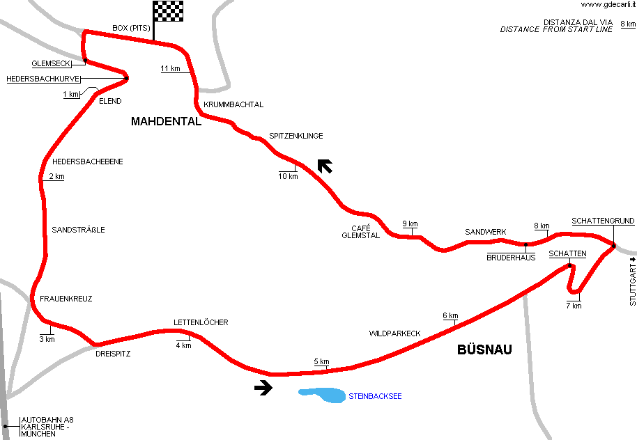
| Description | Start/finish line was near Leonberg and still today (see photo 1, below) you can see "Zeitnehmerhaus" tower on the left and pits on the right. Today here is based an ADAC Verkehrsübungsplatz (traffic exercise area). Hadersbachkurve was a very steep and tight uphill turn, the the track goes on with a steep uphill (up to 18%) up to Elend. From Frauenkreuz the circuit went left, but this section 600 m long up to Dreispitz in 1998 was demolished and replaced by the forest, because of a tread-off for the one cut down for building an Autobahn restaurant. Section after Lettenlöcher was very fast and weavy. After Büsnau village, the circuit goes downhill with some corners up to Schattengrund, where it joins the road that comes from Stuttgart. From here the circuit follows Mahdental (Mahden valley), with Glems creek on the left and hills on the right. There are 10 left and 8 right corners, all difficult because they seems very similar, but they are quite different. | ||||
| Years | 1935÷1965 | ||||
| Direction | Anticlockwise | ||||
| Proposal |
NO | ||||
| No longer operational | YES | ||||
| Car Circuit | YES | ||||
| Motorbike circuit | YES | ||||
| Type | Road course | ||||
| Inauguration | 1935 | ||||
| Closing | 1965 | ||||
| Last update of this page | October 3rd 2008 | ||||
| Info last update | |||||
| Designer | |||||
| Distinctive points | Glemseck - Hadersbachkurve - Elend - Hadersbachebene - Sandsträßle - Frauenkreuz - Dreispitz - Lettenlöcher - Wildparkeck - Schatten - Schattengrund - Bruderhaus - Sandwerk - Café Glemstal - Spitzenklinge - Krumbachtalkurve | ||||
| length | 11500 m | 37730 ft | 7.146 mi | (11) | |
| length | 11700 m | 38386 ft | 7.27 mi | (16) | |
| length | 11417 m | 37457 ft | 7.094 mi | (2) | |
| length | 11401 m | 37404 ft | 7.084 mi | Calculated from aerial photo (*) | (8) |
| Solitude | |||||
| Description | |||||
| Years | 2003 | ||||
| Direction | Clockwise | ||||
| Proposal |
NO | ||||
| No longer operational | YES | ||||
| Car Circuit | YES | ||||
| Motorbike circuit | YES | ||||
| Type | Road course | ||||
| Inauguration | 2003 | ||||
| Closing | 2003 | ||||
| Last update of this page | October 3rd 2008 | ||||
| Info last update | |||||
| Designer | |||||
| Distinctive points | Solitudestraße - Bergheimer Steige - Wildparkstraße - Stuttgarter Straße - K1659 | ||||
| length | 4600 m | 15092 ft | 2.858 mi | (16) | |
| length | 4641 m | 15227 ft | 2.884 mi | Calculated from aerial photo (*) | (7) |
| Bergsprint | |||||
| Description | Hillclimb that used first section of the 1935÷1965 circuit, from after first bend to Frauenkreuz | ||||
| Years | 2006 | ||||
| Direction | |||||
| Proposal |
NO | ||||
| No longer operational | |||||
| Car Circuit | YES | ||||
| Motorbike circuit | YES | ||||
| Type | Hillclimb | ||||
| Inauguration | |||||
| Closing | |||||
| Last update of this page | November 25th 2010 | ||||
| Info last update | September 15th 2006 | ||||
| Designer | |||||
| Distinctive points | |||||
| Solitude Ring | |||||
| Description | Proposed permanent circuit to be built in the same area where there was start/finish line of 1935÷1965 circuit | ||||
| Years | |||||
| Direction | |||||
| Proposal |
YES
| ||||
| Proposal not developed | |||||
| Car Circuit | YES | ||||
| Motorbike circuit | |||||
| Type | Permanent | ||||
| Inauguration | |||||
| Closing | |||||
| Last update of this page | November 25th 2010 | ||||
| Info last update | |||||
| Designer | |||||
| Distinctive points | |||||
Solitude and Gerlingen Circuit: comparison between different track layouts
Due to technical problems, temporarily it’s no longer possible to see the circuits on Google Maps embedded in the current page.
This feature will be restored as soon as I figure out how to do (any help would be appreciated!)
See this track layout with Google Maps - Google Earth
(milermeter.com can be used in your browser, without installing anything; Google Earth is a program that must be installed in your computer)
(Map shown here above can show at the same time all eventual layouts drawn. If you want to see only some of them, please go to Google Maps or Google Earth, by clicking on its own link)
Solitude 1903÷1905
Due to technical problems, temporarily it’s no longer possible to see the circuits on Google Maps embedded in the current page.
This feature will be restored as soon as I figure out how to do (any help would be appreciated!)
See this track layout with Google Maps - Google Earth
- milermeter.com
(milermeter.com can be used in your browser, without installing anything; Google Earth is a program that must be installed in your computer)
(Map shown here above can show at the same time all eventual layouts drawn. If you want to see only some of them, please go to Google Maps or Google Earth, by clicking on its own link)
Solitude 1906÷1924
Due to technical problems, temporarily it’s no longer possible to see the circuits on Google Maps embedded in the current page.
This feature will be restored as soon as I figure out how to do (any help would be appreciated!)
See this track layout with Google Maps - Google Earth
- milermeter.com
(milermeter.com can be used in your browser, without installing anything; Google Earth is a program that must be installed in your computer)
(Map shown here above can show at the same time all eventual layouts drawn. If you want to see only some of them, please go to Google Maps or Google Earth, by clicking on its own link)
Solitude 1935÷1965
Due to technical problems, temporarily it’s no longer possible to see the circuits on Google Maps embedded in the current page.
This feature will be restored as soon as I figure out how to do (any help would be appreciated!)
See this track layout with Google Maps - Google Earth
- milermeter.com
(milermeter.com can be used in your browser, without installing anything; Google Earth is a program that must be installed in your computer)
(Map shown here above can show at the same time all eventual layouts drawn. If you want to see only some of them, please go to Google Maps or Google Earth, by clicking on its own link)
Solitude 2003
Due to technical problems, temporarily it’s no longer possible to see the circuits on Google Maps embedded in the current page.
This feature will be restored as soon as I figure out how to do (any help would be appreciated!)
See this track layout with Google Maps - Google Earth
- milermeter.com
(milermeter.com can be used in your browser, without installing anything; Google Earth is a program that must be installed in your computer)
(Map shown here above can show at the same time all eventual layouts drawn. If you want to see only some of them, please go to Google Maps or Google Earth, by clicking on its own link)
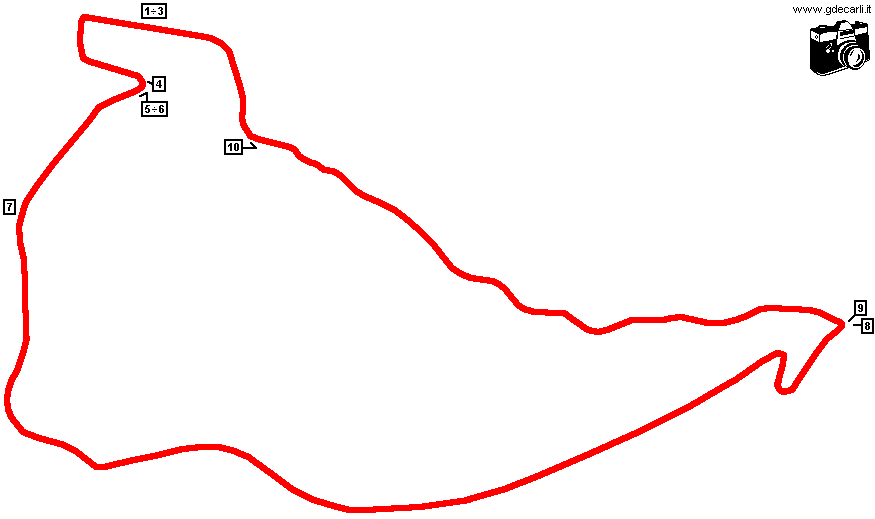
| PHOTOS |
| Photos by Crasher, taken on July 2005 (already posted on tbk.fameflame.dk - Motorsport Photos - Solitude Racetrack Part 1 of 2 and here published with author’s permission). Comments by Crasher slighty modified; Italian translation is mine I went to our great track Solitude near Stuttgart. Unfortunately the power of our camera gave up after "Schattengrund" near Stuttgart-Büsnau. I managed to shot one picture from the last corner, but Mahdental (Mahden valley) is completely missed. Frauenkreuz and Dreispitz are no longer existing today, I hardly searched for them, might have to go trough the forest. On official website (Rennstrecken section) there are some historical pics taken in the same position of the following ones. |
| Photos by Crasher - July 2005 |
| Click on thumbnail to open original large photo |
| 1 | 2 | 3 | 4 |
 |  |  |  |
| The Tower ("Zeitnehmerhaus") and Start/Finish. In the past, in the background there was the paddock for the drivers. Today it’s a driving-school course owned by the ADAC (ADAC Verkehrsübungsplatz) | The Start and Finish Straight. Where you can see the red old house, there were the pitstalls, today it’s nothing more but a entry for the driving course. | A better pic from the pitstalls | Hedersbachkurve |
| 5 | 6 | 7 | 8 |
 |  |  |  |
| From Hedersbachkurve to Elend and Hedersbachebene | From Hedersbachkurve to Elend and Hedersbachebene | Hedersbachebene | Schattengrund. The corner which connects Büsnau to Sandwerk and then over Mahdental (Mahden valley) back to Start/Finish |
| 9 | 10 | ||
 |  | ||
| Schattengrund | Krumbachtalkurve: the last corner before Start/Finish and the section after Mahdental |
| Updates | |||||||
| Date | Track layout | Years | Description by | Map by | Thanks to | Note | |
| December 17th 2010 | Guido de Carli | Martin Berrang | Update | Description | |||
| November 25th 2010 | Guido de Carli | Roelard Smit | Update | Description | |||
| October 6th 2008 | Guido de Carli | Roelard Smit | Update | Description with map | |||
| October 3rd 2008 | Guido de Carli | Guido de Carli | Lorenzo Tommasi | Update | Description with map | ||
| August 20th 2005 | Guido de Carli | Guido de Carli | Update | Description with map | |||
| August 20th 2005 | Guido de Carli | Crasher | Update | Photos (on this site) | |||
| July 25th 2005 | 1935÷1965 | Guido de Carli | Update | Photos (link) | |||
| January 16th 2005 | 1935÷1965 | Guido de Carli | Update | Description without map | |||
| November 17th 2003 | 1935÷1965 | Guido de Carli | Uwe Sautter | Update | Description | ||
| September 16th 2002 | Guido de Carli | New | Description | ||||
| Not all eventual updates issued in last years are already visible in this list | |||||||
Webmaster:
Guido de Carli

(Italiano - English - Español)
HOME PAGE