 Visualizza questa pagina in Italiano
 HOME PAGE
|
Visualizza questa pagina in Italiano
|
HOME PAGE
|
Legend and translations |
| ITA - ITALY | |||||||||||||||||||||
| ASTI | |||||||||||||||||||||
| Not to be confused with | Asti (1926) | ||||||||||||||||||||
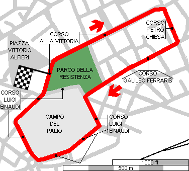
| Description | Street track used from 1946 to 1947. My map shows 2 km layout, probably used un 1946. I have a photo (on Ruoteclassiche) that shows 1947 starting grid, teken in Corso Alla Vittoria (more or less where I took photo No.3), but in contrary direction. Some motorbikes event were held on May 14th 1950 and May 31st 1953, but I don’t know if track layout was the same or not | ||||||||||||||||||||
| Location | Asti AT - Asti - Piemonte | ||||||||||||||||||||
| Location | |||||||||||||||||||||
| Latitude - Longitude | + 44°54'01" + 8°12'39" 44.900278 8.210833 | ||||||||||||||||||||
| UTM Coordinates | X = 437693.762 - Y = 4972175.541 - Zone 32T | ||||||||||||||||||||
| Aerial photo / Map (*) |  Google Maps - Bing Maps - Flash Earth - Portale Cartografico Nazionale - Visual Pagine Gialle Google Maps - Bing Maps - Flash Earth - Portale Cartografico Nazionale - Visual Pagine Gialle | ||||||||||||||||||||
| Altitude AMSL | 121 m - 397 ft | ||||||||||||||||||||
| Inauguration | |||||||||||||||||||||
| Closing | |||||||||||||||||||||
| Designer | |||||||||||||||||||||
| Sources and links (Translation) (**) |
| ||||||||||||||||||||
| Asti | |||||
| Description | |||||
| Years | 1928÷1934 | ||||
| Direction | |||||
 Proposal Proposal |
NO | ||||
| No longer operational | YES | ||||
| Car Circuit | |||||
| Motorbike circuit | YES | ||||
| Type | |||||
| Inauguration | 1928 | ||||
| Closing | 1934 | ||||
| Last update of this page | April 4th 2006 | ||||
| Info last update | |||||
| Designer | |||||
| Distinctive points | |||||
| Asti | |||||
| Description | |||||
| Years | 1946 | ||||
| Direction |  Clockwise Clockwise | ||||
| Proposal |
NO | ||||
| No longer operational | YES | ||||
| Car Circuit | YES | ||||
| Motorbike circuit | |||||
| Type | Street course | ||||
| Inauguration | 1946 | ||||
| Closing | 1946 | ||||
| Last update of this page | February 24th 2009 | ||||
| Info last update | |||||
| Designer | |||||
| Distinctive points | |||||
| length | 2000 m | 6562 ft | 1.243 mi | (2) | |
| length | 1941 m | 6370 ft | 1.206 mi | Calculated from aerial photo (*) | (1) |
| Asti | |||||
| Same circuit? | |||||
| Description | |||||
| Years | 1946÷1947, 1950 | ||||
| Direction | Clockwise | ||||
| Proposal |
NO | ||||
| No longer operational | YES | ||||
| Car Circuit | YES | ||||
| Motorbike circuit | |||||
| Type | Street course | ||||
| Inauguration | 1946 | ||||
| Closing | 1950 | ||||
| Last update of this page | April 4th 2006 | ||||
| Info last update | |||||
| Designer | |||||
| Distinctive points | |||||
| length | 2810 m | 9219 ft | 1.746 mi | (3) | |
| Asti | |||||
| Description | Layout used on May 31st 1953. I don’t know differences with previous layout, nor if it has been used some more times. The same article reported different track length of the same circuit (some data are calculated from average speed) | ||||
| Years | 1953 | ||||
| Direction | |||||
| Proposal |
NO | ||||
| No longer operational | YES | ||||
| Car Circuit | |||||
| Motorbike circuit | YES | ||||
| Type | Street course | ||||
| Inauguration | |||||
| Closing | |||||
| Last update of this page | April 26th 2021 | ||||
| Info last update | June 1st 1953 | ||||
| Designer | |||||
| Distinctive points | |||||
| length | 2013 m | 6604 ft | 1.251 mi | (4) | |
| length | 2394 m | 7854 ft | 1.488 mi | (4) | |
| length | 2400 m | 7874 ft | 1.491 mi | (4) | |
Asti 1946
See this track layout with milermeter.com
(milermeter.com can be used in your browser, without installing anything; Google Earth is a program that must be installed in your computer)
| PHOTOS |
| Photos by Guido de Carli - August 10th 2003 |
| Click on thumbnail to open original large photo |
| 0 | 1 | 2 | 3 |
 |  |  |  |
| This circuit has abandoned more than 50 years ago. This is the only red single seater I could see here! (to be precise, I took this photo near photo 7) | Start/finish straight. White house in background is on the corner between Piazza Vittorio Alfieri (left, outside this photo) and Corso Alla Vittoria (Victory Street; right) | Corso Alla Vittoria (Victory Street; right) | Corso Alla Vittoria (Victory Street). Now is divided into two halves: left one (used by car driving towards camera) is aligned with previous section (shown on photo No. 2). I don’t know anything about 1940s layout. In 1947 starting grid was here, but race direction was towards camera, opposite than 1946. |
| 4 | 5 | 6 | 7 |
 |  |  |  |
| Junction between Corso alla Vittoria (Victory Street; right) e Corso Pietro Chiesa (Pietro Chiesa Street, right) | As previous photo. High building in the middle of the picture can be seen (a little) on the left in previous photo | Corso Galileo Ferraris (Galileo Ferraris Street) seen from its junction with Corso Pietro Chiesa (Pietro Chiesa Street) | Corso Galileo Ferraris (Galileo Ferraris Street), at the beginning of Parco della Resistenza (Resistance Park) |
| 8 | 9 | 10 | 11 |
 |  |  |  |
| Junction between Corso Galileo Ferraris (left, ouside this photo) e Corso Luigi Einaudi (straight on this photo). I don’t think that in 1940s there was grass in foreground in the middle of the junction.... On the right (behind trees): Campo del Palio (Palio’s Square) | Corso Luigi Einaudi. This photo was taken on the grass seen in previous photo, near big metallic pole. On the right (behind trees): Campo del Palio (Palio’s Square) | Corso Luigi Einaudi: bend around Campo del Palio (Palio’s Square) corner | Campo del Palio (Palio’s Square), usually used as a parking |
| 12 | 13 | 14 | 15 |
 |  |  |  |
| Corso Luigi Einaudi: this photo was taken from following Campo del Palio (Palio’s Square) corner and the circuit is shown in contrary direction | Campo del Palio (Palio’s Square), usually used as a parking | Corso Luigi Einaudi. This photo was taken from the same point where photo No. 12 was takem, but according to circuit direction | Corso Luigi Einaudi: this photo was taken from following Campo del Palio (Palio’s Square) corner. Background: last corner |
| 16 | |||
 | |||
| Vittorio Alfieri Square, not used by circuit in my map; if a longer layout has been used, maybe it went also here |
| Updates | |||||||
| Date | Track layout | Years | Description by | Map by | Thanks to | Note | |
| April 26th 2021 | Guido de Carli | Update | Description | ||||
| February 24th 2009 | 1946 | Guido de Carli | Guido de Carli | Update | Description with map | ||
| September 7th 2003 | Guido de Carli | Update | Description | ||||
| August 31st 2003 | Guido de Carli | Update | Description | ||||
| August 13th 2003 | Guido de Carli | Update | Photos (on this site) | ||||
| June 13th 2003 | Guido de Carli | Update | Description | ||||
| May 26th 2003 | Guido de Carli | Guido de Carli | New | Description with map | |||
| Not all eventual updates issued in last years are already visible in this list | |||||||
Webmaster:
Guido de Carli

(Italiano - English - Español)
HOME PAGE