 Visualizza questa pagina in Italiano
 HOME PAGE
|
Visualizza questa pagina in Italiano
|
HOME PAGE
|
Legend and translations |
| ITA - ITALY | |||||||||||||||||||||||||||||
| BERGAMO, MURA | |||||||||||||||||||||||||||||
| Description | Street track located in Bergamo town center («Città Alta»), used on May 19th 1935 for Gran Prix «Coppa Città di Bergamo». From September 26th 2004 some historic events were organized on the same circuit. | ||||||||||||||||||||||||||||
| Location | Bergamo BG - Bergamo - Lombardia | ||||||||||||||||||||||||||||
| Location | Bergamo, Città Alta (old town) | ||||||||||||||||||||||||||||
| Latitude - Longitude | + 45°42'14" + 9°39'50" 45.703889 9.663889 | ||||||||||||||||||||||||||||
| UTM Coordinates | X = 551679.964 - Y = 5061362.69 - Zone 32T | ||||||||||||||||||||||||||||
| Aerial photo / Map (*) |  Google Maps - Bing Maps - Flash Earth - Portale Cartografico Nazionale - Visual Pagine Gialle Google Maps - Bing Maps - Flash Earth - Portale Cartografico Nazionale - Visual Pagine Gialle | ||||||||||||||||||||||||||||
| Altitude AMSL | 385 m - 1263 ft | ||||||||||||||||||||||||||||
| Inauguration | 1934 | ||||||||||||||||||||||||||||
| Closing | |||||||||||||||||||||||||||||
| Designer | |||||||||||||||||||||||||||||
| Sources and links (Translation) (**) |
| ||||||||||||||||||||||||||||
| Circuito delle Mura | |||||
| Description | On May 19th 1935 it hosted 1st Coppa Città di Bergamo (Town of Bergamo Cup), the only car race occurred on this circuit. From 1934 to 1939 and from 1946 to 1950 it could have hosted some motorbike races, but I have no info about them. On September 26th 2004 and September 11th 2005 it hosted 2nd and 3rd Coppa Città di Bergamo, two historical parades | ||||
| Years | 1934÷1939, 1946÷1950, 2004÷2005 | ||||
| Direction |  Clockwise Clockwise | ||||
 Proposal Proposal |
NO | ||||
| No longer operational | YES | ||||
| Car Circuit | YES | ||||
| Motorbike circuit | YES | ||||
| Type | Street course | ||||
| Inauguration | 1934 | ||||
| Closing | September 11th 2005 | ||||
| Last update of this page | February 7th 2011 | ||||
| Info last update | |||||
| Designer | |||||
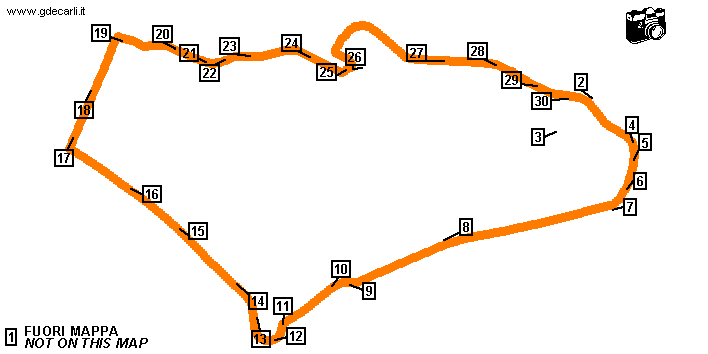
| Distinctive points | Piazzale Sant’Agostino - Porta Sant’Agostino (Curva Sant’Agostino) - Viale delle Mura - Baluardo San Giovanni - Viale Cento Piante - Curva San Giacomo - Baluardo San Giacomo - Baluardo Santa Grata - Curva del Seminario - Viale Colle Aperto - Curva Colle Aperto - Tunnel del Pantano - Piazza Mascheroni - Via della Boccola - Chicane del Lantro - Via San Lorenzo - Curva San Lorenzo - Viale della Fara | ||||
| length | 2920 m | 9580 ft | 1.814 mi | (7) | |
| length | 2924 m | 9593 ft | 1.817 mi | (6) | |
| length | 2917 m | 9569 ft | 1.812 mi | Calculated from aerial photo (*) | (5) |
| Difference in level | 75 m | 246 ft | Calculated from aerial photo (*) | (5) | |
| Circuito delle Mura | |||||
| Description | On May 31st 2008 it hosted Bergamo Historic Gran Prix, a historical parade of the old circuit. The track is unchanged from previous editions, but direction now is anticlockwise and start/finish line was moved to Viale Colle Aperto. Paddock is in Piazza della Cittadella | ||||
| Years | 2008 | ||||
| Direction |  Anticlockwise Anticlockwise | ||||
| Proposal |
NO | ||||
| No longer operational | YES | ||||
| Car Circuit | YES | ||||
| Motorbike circuit | |||||
| Type | Historical parade | ||||
| Inauguration | May 31st 2008 | ||||
| Closing | May 31st 2008 | ||||
| Last update of this page | February 7th 2011 | ||||
| Info last update | |||||
| Designer | |||||
| Distinctive points | Viale Colle Aperto - Curva del Seminario - Baluardo Santa Grata - Baluardo San Giacomo - Curva San Giacomo - Viale Cento Piante - Baluardo San Giovanni - Viale delle Mura - Porta Sant’Agostino (Curva Sant’Agostino) - Piazzale Sant’Agostino - Viale della Fara - Curva San Lorenzo - Via San Lorenzo - Chicane del Lantro - Via della Boccola - Piazza Mascheroni - Tunnel del Pantano - Curva Colle Aperto | ||||
| length | 2920 m | 9580 ft | 1.814 mi | (7) | |
| length | 2917 m | 9569 ft | 1.812 mi | Calculated from aerial photo (*) | (5) |
| Difference in level | 75 m | 246 ft | Calculated from aerial photo (*) | (5) | |
| Circuito delle Mura | |||||
| Description | The circuit is the same used in 2008, but direction is clockwise | ||||
| Years | 2009÷... | ||||
| Direction | Clockwise | ||||
| Proposal |
NO | ||||
| No longer operational | |||||
| Car Circuit | YES | ||||
| Motorbike circuit | |||||
| Type | Historical parade | ||||
| Inauguration | May 31st 2009 | ||||
| Closing | |||||
| Last update of this page | February 7th 2011 | ||||
| Info last update | |||||
| Designer | |||||
| Distinctive points | Viale Colle Aperto - Curva Colle Aperto - Tunnel del Pantano - Piazza Mascheroni - Via della Boccola - Chicane del Lantro - Via San Lorenzo - Curva San Lorenzo - Viale della Fara - Piazzale Sant’Agostino - Porta Sant’Agostino (Curva Sant’Agostino) - Viale delle Mura - Baluardo San Giovanni - Viale Cento Piante - Curva San Giacomo - Baluardo San Giacomo - Baluardo Santa Grata - Curva del Seminario | ||||
| length | 2920 m | 9580 ft | 1.814 mi | (7) | |
| length | 2917 m | 9569 ft | 1.812 mi | Calculated from aerial photo (*) | (5) |
| Difference in level | 75 m | 246 ft | Calculated from aerial photo (*) | (5) | |
Bergamo, Circuito delle Mura: comparison between all layouts
Due to technical problems, temporarily it’s no longer possible to see the circuits on Google Maps embedded in the current page.
This feature will be restored as soon as I figure out how to do (any help would be appreciated!)
See this track layout with Google Maps - Google Earth
(milermeter.com can be used in your browser, without installing anything; Google Earth is a program that must be installed in your computer)
(Map shown here above can show at the same time all eventual layouts drawn. If you want to see only some of them, please go to Google Maps or Google Earth, by clicking on its own link)
Bergamo, Circuito delle Mura (1935, 2004÷2005)

Due to technical problems, temporarily it’s no longer possible to see the circuits on Google Maps embedded in the current page.
This feature will be restored as soon as I figure out how to do (any help would be appreciated!)
See this track layout with Google Maps - Google Earth
- milermeter.com
(milermeter.com can be used in your browser, without installing anything; Google Earth is a program that must be installed in your computer)
(Map shown here above can show at the same time all eventual layouts drawn. If you want to see only some of them, please go to Google Maps or Google Earth, by clicking on its own link)
Bergamo, Circuito delle Mura (2008)
Due to technical problems, temporarily it’s no longer possible to see the circuits on Google Maps embedded in the current page.
This feature will be restored as soon as I figure out how to do (any help would be appreciated!)
See this track layout with Google Maps - Google Earth
(milermeter.com can be used in your browser, without installing anything; Google Earth is a program that must be installed in your computer)
(Map shown here above can show at the same time all eventual layouts drawn. If you want to see only some of them, please go to Google Maps or Google Earth, by clicking on its own link)
Bergamo, Circuito delle Mura (2009÷...)
Due to technical problems, temporarily it’s no longer possible to see the circuits on Google Maps embedded in the current page.
This feature will be restored as soon as I figure out how to do (any help would be appreciated!)
See this track layout with Google Maps - Google Earth
(milermeter.com can be used in your browser, without installing anything; Google Earth is a program that must be installed in your computer)
(Map shown here above can show at the same time all eventual layouts drawn. If you want to see only some of them, please go to Google Maps or Google Earth, by clicking on its own link)
| PHOTOS |
| Photo tour follows the original course, used in 1935 |
| Photos by Guido de Carli - August 2nd 2003 |
| Click on thumbnail to open original large photo |
| 1 | 2 | 3 | 4 |
 |  |  |  |
| Bergamo Alta (High Bergamo, the old town, on a hill) seen from Bergamo Bassa (Low Bergamo, the new town). This photo was taken from a point outside the map. It is possible to see town wall, more or less from point 12 (left) to 7 (right) on the map. | S.Agostino Church. Start line was more or less in this point | S.Agostino Church. I have no info, but I think that this area, where now there is a football playground, was used for boxes and paddock | S.Agostino Town Door. This is the lowest section of the circuit, here a long climb along town walls starts. |
| 5 | 6 | 7 | 8 |
 |  |  |  |
| This photo was taken a few meters ahead the previous one | Viale delle Mura (Wall Street): initial corner | Viale delle Mura (Wall Street): first straight | Viale delle Mura (Wall Street): first straight, after a little bend (in background on previous photo) |
| 9 | 10 | 11 | 12 |
 |  |  |  |
| Viale delle Mura (Wall Street): right-left chicane | Viale delle Mura (Wall Street): exit from chicane of the previous photo | Viale delle Mura (Wall Street): Porta San Giacomo (St. James Town Door). In background: beginning of hairpin | Viale delle Mura (Wall Street): Porta San Giacomo hairpin |
| 13 | 14 | 15 | 16 |
 |  |  |  |
| Viale delle Mura (Wall Street): exit from Porta San Giacomo hairpin. Try to guess whose is bycicle in foreground! | Viale delle Mura (Wall Street): second straight | Viale delle Mura (Wall Street): second straight. Renault Megane parked on the left is the same in background on previous photo | Viale delle Mura (Wall Street): second straight. This (low quality) photo was taken more or less where - on previous photos - there are car driving on the road. |
| 17 | 18 | 19 | 20 |
 |  |  |  |
| Colle Aperto (Open Col) taken from the corner | Colle Aperto (Open Col). This photo was taken at middle straight, on the higher point of the circuit | Beginning of Via della Boccola. The track came down from the right and it turned on the round in front of photographer. Behind photographer there is Porta Sant’Alessandro (St.Alexander Town Door) | Via della Boccola. It’s hard to believe, but I think that circuit went here, as there are no alternative roads |
| 21 | 22 | 23 | 24 |
 |  |  |  |
| Via della Boccola seen from Piazza Mascheroni | Via della Boccola | Via della Boccola | Via della Boccola. Crane is just behind San Lorenzo (St.Lorenz) Church. |
| 25 | 26 | 27 | 28 |
 |  |  |  |
| Via della Boccola seen from San Lorenzo (St.Lorenz) Church. The circuit went left with a tight downhill hairpin, hidden between the little wall and the yellow house | Via San Lorenzo (St.Lorenz Street). This street wasn’t used by the circuit, this pic was taken because of a mistake | Via Fara | Via Fara. In background: finish line and Piazzale S.Agostino |
| 29 | 30 | ||
 |  | ||
| Via Fara. In background: finish line and Piazzale S.Agostino | Piazzale S.Agostino (see photos 2 and 3) |
| Updates | |||||||
| Date | Track layout | Years | Description by | Map by | Thanks to | Note | |
| February 7th 2011 | Guido de Carli | Guido de Carli | Simone Tacconi | Update | Description with map | ||
| September 23rd 2008 | Circuito delle Mura | 1934÷1939, 1946÷1950, 2004÷2005 | Guido de Carli | Simone Tacconi | Update | Description | |
| September 11th 2008 | Guido de Carli | Martin Berrang | Update | Description | |||
| October 3rd 2004 | Circuito delle Mura | 1934÷1939, 1946÷1950, 2004÷2005 | Guido de Carli | Guido de Carli | Update | Description with map | |
| September 27th 2004 | Circuito delle Mura | 1934÷1939, 1946÷1950, 2004÷2005 | Guido de Carli | New | Description | ||
| August 3rd 2003 | Circuito delle Mura | 1934÷1939, 1946÷1950, 2004÷2005 | Guido de Carli | New | Photos (on this site) | ||
| August 3rd 2003 | Circuito delle Mura | 1934÷1939, 1946÷1950, 2004÷2005 | Guido de Carli | Update | Description | ||
| May 21st 2003 | Circuito delle Mura | 1934÷1939, 1946÷1950, 2004÷2005 | Guido de Carli | Guido de Carli | New | Description with map | |
| Not all eventual updates issued in last years are already visible in this list | |||||||
Webmaster:
Guido de Carli

(Italiano - English - Español)
HOME PAGE