 Visualizza questa pagina in Italiano
 HOME PAGE
|
Visualizza questa pagina in Italiano
|
HOME PAGE
|
Legend and translations |
| ARG - ARGENTINA | |||||||||||||||||||||||||||||||||
| BAHíA BLANCA, CARLOS MARTíN / VILLA BORDEU | |||||||||||||||||||||||||||||||||
| Not to be confused with | Bahía Blanca, Aldea Romana, Ezequiel Crisol - Bahía Blanca, Base Contraalmirante Espora | ||||||||||||||||||||||||||||||||
| Description | Circuit opened in 1958 as Autódromo de Villa Bordeu. On April 16th 1967 it was renamed Autódromo Carlos J.Martín, after the driver died after a crash occurred during F.3 race at Mar del Plata, Golf Club circuit, on January 29th 1967. The track have been closed for decades | ||||||||||||||||||||||||||||||||
| Location | Villa Bordeu, Bahía Blanca B - Buenos Aires - Buenos Aires | ||||||||||||||||||||||||||||||||
| Location | On National Road 33 | ||||||||||||||||||||||||||||||||
| Latitude - Longitude | - 38°41'58" - 62°20'00" -38.699444 -62.333333 | ||||||||||||||||||||||||||||||||
| UTM Coordinates | X = 557971.581 - Y = 5716364.703 - Zone 20H | ||||||||||||||||||||||||||||||||
| Aerial photo / Map (*) |  Google Maps - Bing Maps - Flash Earth Google Maps - Bing Maps - Flash Earth | ||||||||||||||||||||||||||||||||
| Altitude AMSL | 16 m - 52 ft | ||||||||||||||||||||||||||||||||
| Inauguration | November 23rd 1958 | ||||||||||||||||||||||||||||||||
| Closing | |||||||||||||||||||||||||||||||||
| Designer | |||||||||||||||||||||||||||||||||
| Sources and links (Translation) (**) |
| ||||||||||||||||||||||||||||||||
| Autódromo de Villa Bordeu / Autódromo Carlos J.Martín | |||||
| Description | |||||
| Years | |||||
| Direction | |||||
 Proposal Proposal |
NO | ||||
| No longer operational | YES | ||||
| Car Circuit | YES | ||||
| Motorbike circuit | YES | ||||
| Type | |||||
| Inauguration | November 23rd 1958 | ||||
| Closing | |||||
| Last update of this page | June 21st 2011 | ||||
| Info last update | |||||
| Designer | |||||
| Distinctive points | |||||
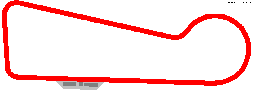
| length | 1950 m | 6398 ft | 1.212 mi | (3) | |
| length | 1955 m | 6414 ft | 1.215 mi | Calculated from aerial photo (*) | |
Bahía Blanca: Autódromo de Villa Bordeu / Autódromo Carlos J.Martín
Due to technical problems, temporarily it’s no longer possible to see the circuits on Google Maps embedded in the current page.
This feature will be restored as soon as I figure out how to do (any help would be appreciated!)
See this track layout with Google Maps - Google Earth
(milermeter.com can be used in your browser, without installing anything; Google Earth is a program that must be installed in your computer)
(Map shown here above can show at the same time all eventual layouts drawn. If you want to see only some of them, please go to Google Maps or Google Earth, by clicking on its own link)
| Updates | |||||||
| Date | Track layout | Years | Description by | Map by | Thanks to | Note | |
| July 7th 2011 | Autódromo de Villa Bordeu / Autódromo Carlos J.Martín | Guido de Carli | Michel Marti | Michel Marti | Update | Description with map | |
| June 22nd 2011 | Autódromo de Villa Bordeu / Autódromo Carlos J.Martín | Guido de Carli | Guido de Carli | Luis Alberto González | New | Description with map | |
| Not all eventual updates issued in last years are already visible in this list | |||||||
Webmaster:
Guido de Carli

(Italiano - English - Español)
HOME PAGE