 Visualizza questa pagina in Italiano
 HOME PAGE
|
Visualizza questa pagina in Italiano
|
HOME PAGE
|
Legend and translations |
| ITA - ITALY | |||||
| GARDA (PIETRAMURATA) | |||||
| SORRY, SOME DATA ARE NOT TRANSLATED YET | |||||
| Not to be confused with | Garda (Lonato) - Garda (Maguzzano) - Garda (Salò) - Lonato, South Garda | ||||
| Description | In May 1966 a permanent circuit was proposed in the area between Lake Garda and Trento, at Pietramurata. 4 years later the proposal was approved by CSAI too. Its designer, Mr. Gentilini, think that it would have costed 1200 millions of lire (late 1969). The field was a waste land and it would have been borrowed by the local Commune for free. The track would have had some uphill and downhill. | ||||
| Location | Pietramurata, Dro TN - Trento - Trentino-Alto Adige/Südtirol | ||||
| Location | In an area between Lake Cavedine and river Sarca, in commune of Dro. It’s 20 km - 12.5 mi North East of Riva del Garda and 23 km - 14 mi South West of Trento | ||||
| Latitude - Longitude (approx) | + 45°58'00" + 10°55'00" (approx) 45.966667 10.916667 (approx) | ||||
| UTM Coordinates (approx) | X = 648500.159 - Y = 5092130.018 - Zone 32T (approx) | ||||
| Aerial photo / Map (*) |  Google Maps - Bing Maps - Flash Earth - Portale Cartografico Nazionale - Visual Pagine Gialle Google Maps - Bing Maps - Flash Earth - Portale Cartografico Nazionale - Visual Pagine Gialle | ||||
| Altitude AMSL (approx) | 120 m - 394 ft (approx) | ||||
| Inauguration | |||||
| Closing | |||||
| Designer | |||||
| Sources and links (Translation) (**) |
| ||||
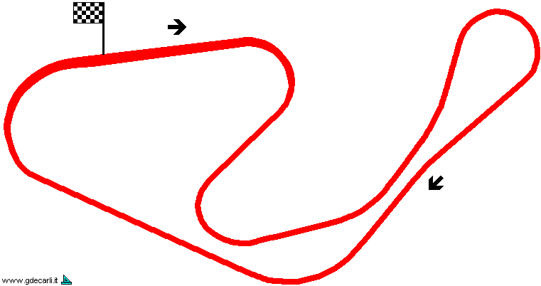
| Autodromo del Garda | |||||
| Description | |||||
| Years | |||||
| Direction |  Clockwise Clockwise | ||||
 Proposal Proposal |
YES
| ||||
| Proposal not developed | YES | ||||
| Car Circuit | YES | ||||
| Motorbike circuit | |||||
| Type | Permanent | ||||
| Inauguration | |||||
| Closing | |||||
| Last update of this page | July 16th 2005 | ||||
| Info last update | February 1970 | ||||
| Designer | |||||
| Distinctive points | |||||
| length | 4070 m | 13353 ft | 2.529 mi | (1) | |
| Min width | 9.4 m | 31 ft | (1) | ||
| Max width | 14.4 m | 47 ft | Start finish straight | (1) | |
Garda (Pietramurata)
| Updates | |||||||
| Date | Track layout | Years | Description by | Map by | Thanks to | Note | |
| July 16th 2005 | Autodromo del Garda | Guido de Carli | Guido de Carli | New | Description with map | ||
| Not all eventual updates issued in last years are already visible in this list | |||||||
Webmaster:
Guido de Carli

(Italiano - English - Español)
HOME PAGE