 Visualizza questa pagina in Italiano
 HOME PAGE
|
Visualizza questa pagina in Italiano
|
HOME PAGE
|
Legend and translations |
| ARG - ARGENTINA | |||||||||||||||||||||
| SANTA ROSA, PARQUE CIUDAD | |||||||||||||||||||||
| Not to be confused with | Santa Rosa, autódromo - Santa Rosa, Provincia de la Pampa | ||||||||||||||||||||
| Description | Circuit first used on December 11th 1978. Now (end of 2004) it’s in bad condition and it’s used only for bycicle races. A completely new circuit has been proposed. | ||||||||||||||||||||
| Location | Santa Rosa L - La Pampa - Patagonia | ||||||||||||||||||||
| Location | |||||||||||||||||||||
| Latitude - Longitude | - 36°36'14" - 64°13'49" -36.603889 -64.230278 | ||||||||||||||||||||
| UTM Coordinates | X = 389967.029 - Y = 5948363.574 - Zone 20H | ||||||||||||||||||||
| Aerial photo / Map (*) |  Google Maps - Bing Maps - Flash Earth Google Maps - Bing Maps - Flash Earth | ||||||||||||||||||||
| Altitude AMSL | 185 m - 607 ft | ||||||||||||||||||||
| Inauguration | December 11th 1978 | ||||||||||||||||||||
| Closing | |||||||||||||||||||||
| Designer | |||||||||||||||||||||
| Sources and links (Translation) (**) |
| ||||||||||||||||||||
| Parque Ciudad de Santa Rosa | |||||
| Description | |||||
| Years | |||||
| Direction |  Clockwise Clockwise | ||||
 Proposal Proposal |
NO | ||||
| No longer operational | |||||
| Car Circuit | YES | ||||
| Motorbike circuit | |||||
| Type | Permanent | ||||
| Inauguration | December 11th 1978 | ||||
| Closing | |||||
| Last update of this page | July 8th 2007 | ||||
| Info last update | |||||
| Designer | |||||
| Distinctive points | |||||
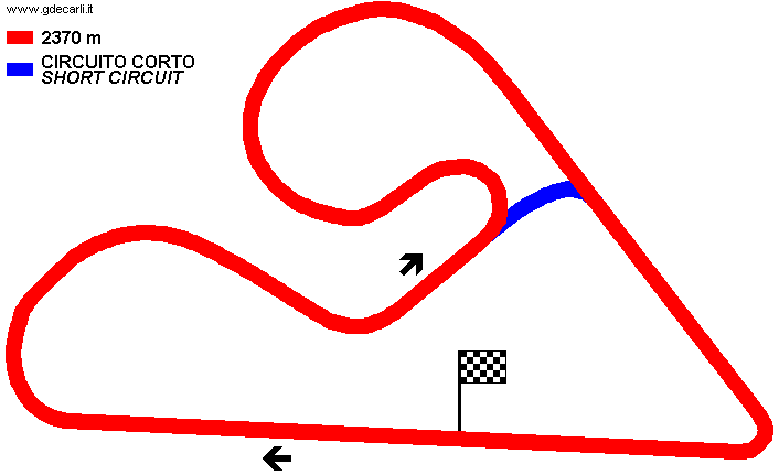
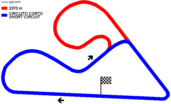
| length | 2370 m | 7776 ft | 1.473 mi | (5) | |
| length | 2370 m | 7776 ft | 1.473 mi | (2) | |
Parque Ciudad de Santa Rosa
| Updates | |||||||
| Date | Track layout | Years | Description by | Map by | Thanks to | Note | |
| November 5th 2007 | Guido de Carli | Update | Description without map | ||||
| July 8th 2007 | Guido de Carli | Update | Description | ||||
| December 30th 2004 | Parque Ciudad de Santa Rosa | Guido de Carli | Guido de Carli | New | Description with map | ||
| September 15th 2004 | Parque Ciudad de Santa Rosa | Guido de Carli | New | Description | |||
| Not all eventual updates issued in last years are already visible in this list | |||||||
Webmaster:
Guido de Carli

(Italiano - English - Español)
HOME PAGE