 Visualizza questa pagina in Italiano
 HOME PAGE
|
Visualizza questa pagina in Italiano
|
HOME PAGE
|
Legend and translations |
| POR - PORTUGAL | |||||||||||||||||||||||||
| MONSANTO & MONTE CLAROS | |||||||||||||||||||||||||
| Not to be confused with | Lisboa (WTCC 2014) | ||||||||||||||||||||||||
| Description | First race in this area was a hillclimb raced in 1910 on a section 1506 m - 0.938 mi long of Estrada de Pimenteira. Even there were more than 30000 spectators, this event was hosted only two more times, in 1913 and 1922. Serra de Monsanto (= Holy Hill) street track was used from 1953 to 1959 and it used also a section of Lisbon-Cascais motorway. In 1959 it was a little shortened, but I don’t know what changes were made. It hosted Portugal GP in 1954, 1957 (both for Sportscar) and 1959 (F.1). It was a dangerous circuit even according to 1950s standard because it was very bumby and uneven. From 1961 to 1971 a shorter circuit was used, known as Monte Claros, because it was not possible to stop the traffic for a weekend on the motorway. In 1980 there were rumors about a remake of the track in order to host a Portugal F.1 GP in 1982. | ||||||||||||||||||||||||
| Location | Parque Forestal De Monsanto, Lisboa - Lisboa - Portugal continental | ||||||||||||||||||||||||
| Location | |||||||||||||||||||||||||
| Latitude - Longitude | + 38°43'11" - 9°11'57" 38.719722 -9.199167 | ||||||||||||||||||||||||
| UTM Coordinates | X = 482685.94 - Y = 4285693.405 - Zone 29S | ||||||||||||||||||||||||
| Aerial photo / Map (*) |  Google Maps - Bing Maps - Flash Earth Google Maps - Bing Maps - Flash Earth | ||||||||||||||||||||||||
| Altitude AMSL | 140 m - 459 ft | ||||||||||||||||||||||||
| Inauguration | 1953 | ||||||||||||||||||||||||
| Closing | 1971 | ||||||||||||||||||||||||
| Designer | |||||||||||||||||||||||||
| Sources and links (Translation) (**) |
| ||||||||||||||||||||||||
| Monsanto | |||||
| Description | |||||
| Years | 1953÷1957 | ||||
| Direction |  Clockwise Clockwise | ||||
 Proposal Proposal |
NO | ||||
| No longer operational | YES | ||||
| Car Circuit | YES | ||||
| Motorbike circuit | |||||
| Type | Street course | ||||
| Inauguration | 1953 | ||||
| Closing | 1957 | ||||
| Last update of this page | August 31st 2003 | ||||
| Info last update | |||||
| Designer | |||||
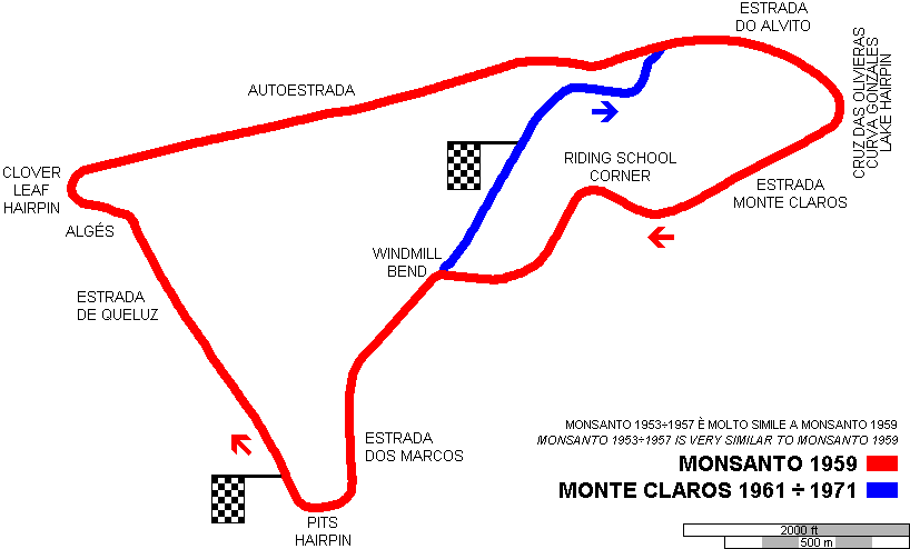
| Distinctive points | Estrada de Queluz - Algés - Clover Leaf Hairpin - Autoestrada - Estrada do Alvito - Cruz das Olivieras, Curva González o Lake Hairpin - Estrada Monte Claros - Riding School Corner - Windmill Bend - Estrada Dos Marcos - Pits Hairpin | ||||
| length | 5633 m | 18479 ft | 3.5 mi | (3) | |
| Monsanto | |||||
| Description | |||||
| Years | 1959 | ||||
| Direction | Clockwise | ||||
| Proposal |
NO | ||||
| No longer operational | YES | ||||
| Car Circuit | YES | ||||
| Motorbike circuit | |||||
| Type | Street course | ||||
| Inauguration | 1959 | ||||
| Closing | 1959 | ||||
| Last update of this page | August 31st 2003 | ||||
| Info last update | |||||
| Designer | |||||
| Distinctive points | Estrada de Queluz - Algés - Clover Leaf Hairpin - Autoestrada - Estrada do Alvito - Cruz das Olivieras, Curva González o Lake Hairpin - Estrada Monte Claros - Riding School Corner - Windmill Bend - Estrada Dos Marcos - Pits Hairpin | ||||
| length | 5439 m | 17846 ft | 3.38 mi | (3) | |
| Monte Claros | |||||
| Description | Street track used from 1961 to 1971. Its street were mainly used also for Monsanto circuit in 1950s. | ||||
| Years | 1961÷1971 | ||||
| Direction | Clockwise | ||||
| Proposal |
NO | ||||
| No longer operational | YES | ||||
| Car Circuit | YES | ||||
| Motorbike circuit | |||||
| Type | Street course | ||||
| Inauguration | 1961 | ||||
| Closing | 1971 | ||||
| Last update of this page | January 27th 2005 | ||||
| Info last update | |||||
| Designer | |||||
| Distinctive points | Estrada do Alvito - Cruz das Olivieras, Curva González o Lake Hairpin - Estrada Monte Claros - Riding School Corner - Windmill Bend | ||||
| length | 2729 m | 8953 ft | 1.696 mi | ||
Monsanto 1959
Monte Claros 1961÷1971
| PHOTOS |
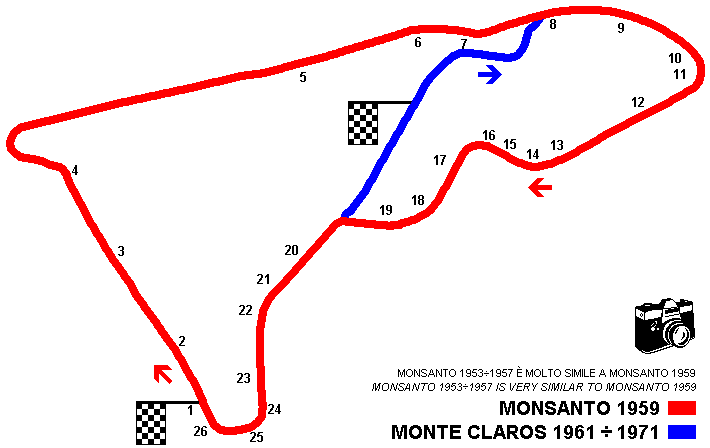
| Photos by Barry Boor, taken on June 5th 2002 (already posted on Atlas F.1 - The Nostalgia Forum and here published with author’s permission). Comments by Barry Boor slighty modified (but photos 10-11, from MotorSport); Italian translation is mine (....) It took but a few minutes to drive along to the point on the motorway where the Grand Prix circuit joined it. Apparently this motorway has been rebuilt since 1959 so we were hardly travelling the same stretch of road but, no matter, we were in the right place. We dropped off the motorway onto a link road that runs into the park. The shape of the gentle right (Photo No.6), then left (7) curves looks pretty accurate when compared to the circuit map but may be in a slightly different place to the original. Once into the park the first thing one finds is a roundabout (8) which of course, was not there in ’59. However, from the other side of this roundabout the next mile and a half (2.4 km approx) or so are absolutely spot-on to the original track. Later, as the circuit runs down towards the bottom left corner, where it joins the Estrada dos Marcos (Windmill bend?), the road has been widened (I think). A problem occurred at the very bottom of the track as there is a one-way system now in operation between the 2 roundabouts not shown on the map (23 and 1), and it goes the wrong way. (....) Once round the bend (Pits hairpin), there is one of the best fish restaurant in Lisbon. At that point, there is another roundabout (1) and this, I think, would have been just about where the start/finish point was on the circuit. Once across the roundabout I was surprised to find the road (Estrada de Queluz, 2 - 3) dropping down VERY steeply as it approached the corners that lead back onto the motorway. About half-way down this section (3), I had to get out again because the traffic is routed off to the left. The road, however, does continue down its original path, ending in a tight left-hand bend (4) which in 1959 led into a right hander (Clover Leaf hairpin) back onto the straight. The road here has been altered so that although cars still turn around onto the motorway at this point, it cannot be the original piece of road. (....) So what did I learn? Well, number one is that trees grow an enormous amount in 43 years! It is going to be very had to tie in what I have on my camera with the photos that I have seen from the race in 1959. Where there was scrub land beside the track, there is now forest. In several places on the original circuit it was possible to see right down to the river but now that can only be seen from one point - entering the double right hander at the bottom of the circuit (Pits hairpin?). The section of road from the exit off the motorway (6) round to the bottom corner (Pits hairpin?) must have been very exciting in a narrow-tyred 2.5 litre F1 car. The bends are not tight and would, I imagine have been very fast; as would the run downhill from the start. (....) Some things should be mentioned: the images are stills taken from a video camera in a moving car (with a few exceptions) so they are not as clear as still photos - apologies for that. (....) The numbers on the previous map indicate where each image is taken from. One or two may be in slightly the wrong place but not far out, I hope! There are several roundabouts that obviously were not there in 1959 - I have excluded them from the map. Finally, it must be remembered that the trees in the park were planted around 1940 (info courtesy of Carlos Guerra) so when the Grand Prix was run there, they had been growing for a maximum of 19 years - probably some for considerably less time - whereas they have had another 43 years more time to grow, hence the fact that the track is almost entirely tree lined. All images except 24 and 26 are looking in the direction the cars travelled. The two aforementioned look back up the road (....) |
| Photos by Barry Boor - June 5th 2002 |
| Click on thumbnail to open original large photo |
| 1 | 2 | 3 | 4 |
 |  |  |  |
| I think this crossing is just about where the start/finish point was | Downhill just after start line | Downhill just after start line | Clover Leaf hairpin and motorway entrance |
| 5 | 6 | 7 | 8 |
 |  |  |  |
| Motorway | Motorway exit | Estrada do Alvito |
| 9 | 10 | 11 | 12 |
 |  |  |  |
| Estrada do Alvito | Cruz das Olivieras or Lake hairpin. It was renamed Curva González (González Corner) because Froilán González had here an accident during 1954 Portugal GP for sportscar. Here Jack Brabham had a terrifying accident too, in Portugal F.1 GP 1959, when lapping Mário de Araújo Cabral: he became airborne and he was chucked out just before the car hit with a concrete telegraph pole. Rolling over and over in the road, he he was skimmed by Master Gregory by mere inches. He miraculously escaped with only a heavily bruised knee.s | Cruz das Olivieras or Lake hairpin. It was renamed Curva González (González Corner) because Froilán González had here an accident during 1954 Portugal GP for sportscar. Here Jack Brabham had a terrifying accident too, in Portugal F.1 GP 1959, when lapping Mário de Araújo Cabral: he became airborne and he was chucked out just before the car hit with a concrete telegraph pole. Rolling over and over in the road, he he was skimmed by Master Gregory by mere inches. He miraculously escaped with only a heavily bruised knee.s | Estrada Monte Claros |
| 13 | 14 | 15 | 16 |
 |  |  |  |
| Riding school corner |
| 17 | 18 | 19 | 20 |
 |  |  |  |
| Estrada dos Marcos |
| 21 | 22 | 23 | 24 |
 |  |  |  |
| Estrada dos Marcos | Estrada dos Marcos | Estrada dos Marcos | This photo look back up the road |
| 25 | 26 | ||
 |  | ||
| Pits hairpin | Pits hairpin. This photo look back up the road |
| Updates | |||||||
| Date | Track layout | Years | Description by | Map by | Thanks to | Note | |
| October 25th 2005 | Monsanto | 1959 | Guido de Carli | Update | Description | ||
| October 25th 2005 | Monte Claros | 1961÷1971 | Guido de Carli | Update | Description | ||
| January 27th 2005 | Monsanto | 1959 | Guido de Carli | Update | Description | ||
| January 27th 2005 | Monsanto | 1959 | Guido de Carli | New | Description without map | ||
| September 27th 2003 | Guido de Carli | Update | Description | ||||
| August 31st 2003 | Monsanto | 1959 | Guido de Carli | Guido de Carli | New | Description with map | |
| August 31st 2003 | Monte Claros | 1961÷1971 | Guido de Carli | Guido de Carli | New | Description with map | |
| August 31st 2003 | Monsanto | 1959 | Guido de Carli | New | Photos (on this site) | ||
| July 14th 2003 | Monsanto | 1953÷1957 | Guido de Carli | New | Description | ||
| Not all eventual updates issued in last years are already visible in this list | |||||||
Webmaster:
Guido de Carli

(Italiano - English - Español)
HOME PAGE