 Visualizza questa pagina in Italiano
 HOME PAGE
|
Visualizza questa pagina in Italiano
|
HOME PAGE
|
Legend and translations |
| SUI - SWITZERLAND | |||||||||||||
| PORRENTRUY | |||||||||||||
| Description | Street circuit used in 1950s, for sure in 1954. I have no more info. | ||||||||||||
| Location | Porrentruy JU - Jura - Espace Mittelland | ||||||||||||
| Location | Between Porrentruy and Courtedoux (canton Jura), approx. 65 km - 40 mi South West of Basel | ||||||||||||
| Latitude - Longitude | + 47°24'23" + 7°02'46" 47.406389 7.046111 | ||||||||||||
| UTM Coordinates | X = 352586.907 - Y = 5252176.99 - Zone 32T | ||||||||||||
| Swiss national coordinates | Y = 570373 - X = 250694 | ||||||||||||
| Aerial photo / Map (*) |  Google Maps - Bing Maps - Flash Earth - map.search.ch Google Maps - Bing Maps - Flash Earth - map.search.ch | ||||||||||||
| Altitude AMSL | 450 m - 1476 ft | ||||||||||||
| Inauguration | |||||||||||||
| Closing | |||||||||||||
| Designer | |||||||||||||
| Sources and links (Translation) (**) |
| ||||||||||||
| Porrentruy | |||||
| Description | |||||
| Years | |||||
| Direction |  Clockwise Clockwise | ||||
 Proposal Proposal |
NO | ||||
| No longer operational | YES | ||||
| Car Circuit | YES | ||||
| Motorbike circuit | |||||
| Type | Road course | ||||
| Inauguration | |||||
| Closing | |||||
| Last update of this page | November 14th 2005 | ||||
| Info last update | |||||
| Designer | |||||
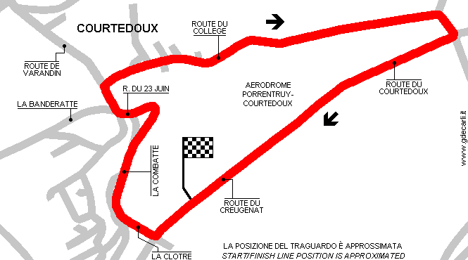
| Distinctive points | Route du Creugenat - La Clotre - La Combatte - R. du 23 Juin - Route du College - Route du Courtedoux | ||||
| length | 3492 m | 11457 ft | 2.17 mi | (3) | |
Porrentruy
Due to technical problems, temporarily it’s no longer possible to see the circuits on Google Maps embedded in the current page.
This feature will be restored as soon as I figure out how to do (any help would be appreciated!)
See this track layout with Google Maps - Google Earth
(milermeter.com can be used in your browser, without installing anything; Google Earth is a program that must be installed in your computer)
(Map shown here above can show at the same time all eventual layouts drawn. If you want to see only some of them, please go to Google Maps or Google Earth, by clicking on its own link)
| Updates | |||||||
| Date | Track layout | Years | Description by | Map by | Thanks to | Note | |
| April 27th 2007 | Guido de Carli | Update | Google Earth / Google Map file | ||||
| November 14th 2005 | Guido de Carli | Guido de Carli | Barry Boor | New | Description with map | ||
| July 20th 2003 | Guido de Carli | New | Description | ||||
| Not all eventual updates issued in last years are already visible in this list | |||||||
Webmaster:
Guido de Carli

(Italiano - English - Español)
HOME PAGE