 Visualizza questa pagina in Italiano
 HOME PAGE
|
Visualizza questa pagina in Italiano
|
HOME PAGE
|
Legend and translations |
| USA - UNITED STATES | |||||||||||||
| DENVER, PEPSI CENTER | |||||||||||||
| Description | (coming soon) | ||||||||||||
| Location | Pepsi Center, Denver CO - Colorado - Western States | ||||||||||||
| Location | Around Pepsi Center, Denver | ||||||||||||
| Latitude - Longitude | + 39°44'49" -105°00'31" 39.746944 -105.008611 | ||||||||||||
| UTM Coordinates | X = 499262.262 - Y = 4399671.128 - Zone 13S | ||||||||||||
| Aerial photo / Map (*) |  Google Maps - Bing Maps - Flash Earth - Microsoft Research Maps - MapQuest Google Maps - Bing Maps - Flash Earth - Microsoft Research Maps - MapQuest | ||||||||||||
| Altitude AMSL | 1581 m - 5187 ft | ||||||||||||
| Inauguration | September 1st 2002 | ||||||||||||
| Closing | |||||||||||||
| Designer | |||||||||||||
| Sources and links (Translation) (**) |
| ||||||||||||
| Denver, Pepsi Center | |||||
| Description | |||||
| Years | 2001 | ||||
| Direction |  Anticlockwise Anticlockwise | ||||
 Proposal Proposal |
YES
| ||||
| Proposal not developed | YES | ||||
| Car Circuit | YES | ||||
| Motorbike circuit | |||||
| Type | Street course | ||||
| Inauguration | September 1st 2002 | ||||
| Closing | August 31st 2003 | ||||
| Last update of this page | August 29th 2007 | ||||
| Info last update | |||||
| Designer | |||||
| Distinctive points | |||||
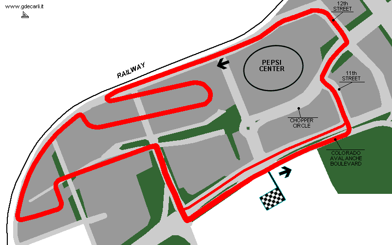
| length (approx) | 3219 m | 10560 ft | 2 mi | (1) | |
| Denver, Pepsi Center | |||||
| Description | |||||
| Years | 2002÷2003 | ||||
| Direction | Anticlockwise | ||||
| Proposal |
NO | ||||
| No longer operational | YES | ||||
| Car Circuit | YES | ||||
| Motorbike circuit | |||||
| Type | Street course | ||||
| Inauguration | September 1st 2002 | ||||
| Closing | August 31st 2003 | ||||
| Last update of this page | July 23rd 2006 | ||||
| Info last update | |||||
| Designer | |||||
| Distinctive points | |||||
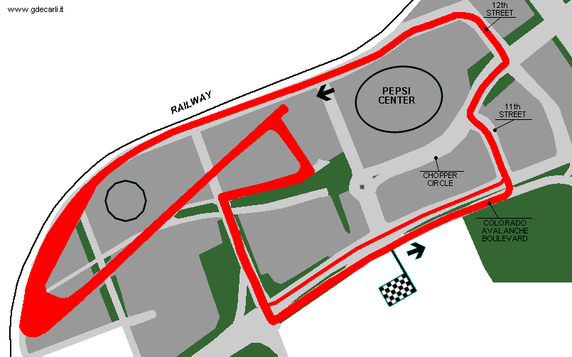
| length | 2651 m | 8696 ft | 1.647 mi | (2) | |
| Denver, Pepsi Center | |||||
| Description | |||||
| Years | 2004÷... | ||||
| Direction | Anticlockwise | ||||
| Proposal |
NO | ||||
| No longer operational | |||||
| Car Circuit | YES | ||||
| Motorbike circuit | |||||
| Type | Street course | ||||
| Inauguration | August 15th 2004 | ||||
| Closing | |||||
| Last update of this page | July 23rd 2006 | ||||
| Info last update | |||||
| Designer | |||||
| Distinctive points | |||||
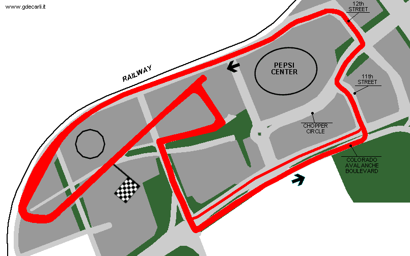
| length | 2667 m | 8749 ft | 1.657 mi | (2) | |
Unofficial proposal not developed Denver Pepsi Center 2002
Denver Pepsi Center 2002÷2003
Denver Pepsi Center 2004÷...
| Updates | |||||||
| Date | Track layout | Years | Description by | Map by | Thanks to | Note | |
| July 23rd 2006 | Guido de Carli | Lorenzo Tommasi | Update | Description with map | |||
| April 22nd 2006 | 2002÷2003 | Guido de Carli | Update | Description | |||
| April 22nd 2006 | 2002÷2003 | Guido de Carli | Lorenzo Tommasi | Update | Description | ||
| November 10th 2002 | Guido de Carli | Update | Map | ||||
| August 6th 2002 | Guido de Carli | Update | Description | ||||
| Not all eventual updates issued in last years are already visible in this list | |||||||
Webmaster:
Guido de Carli

(Italiano - English - Español)
HOME PAGE