 Visualizza questa pagina in Italiano
 HOME PAGE
|
Visualizza questa pagina in Italiano
|
HOME PAGE
|
Legend and translations |
| AUT - AUSTRIA | |||||||||||||||||||||
| TULLN-LANGENLEBARN | |||||||||||||||||||||
| SORRY, SOME DATA ARE NOT TRANSLATED YET | |||||||||||||||||||||
| Description | This circuit was in an military airfield still in use. There were no permanent facilities and straw bales marked the course | ||||||||||||||||||||
| Location | Tulln-Langenlebarn 3 - Niederösterreich | ||||||||||||||||||||
| Location | Approx. 30 km North from Wien, near River Danube | ||||||||||||||||||||
| Latitude - Longitude | + 48°19'01" + 16°06'57" 48.316944 16.115833 | ||||||||||||||||||||
| UTM Coordinates | X = 582724.415 - Y = 5352129.842 - Zone 33U | ||||||||||||||||||||
| Aerial photo / Map (*) |  Google Maps - Bing Maps - Flash Earth Google Maps - Bing Maps - Flash Earth | ||||||||||||||||||||
| Altitude AMSL | 170 m - 558 ft | ||||||||||||||||||||
| Inauguration | |||||||||||||||||||||
| Closing | |||||||||||||||||||||
| Designer | |||||||||||||||||||||
| Sources and links (Translation) (**) |
| ||||||||||||||||||||
| Tulln-Langenlebarn | |||||
| Description | |||||
| Years | |||||
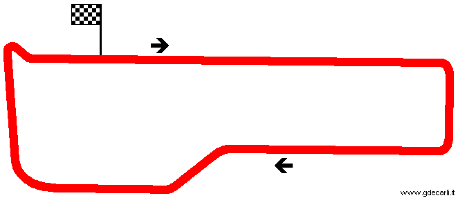
| Direction |  Clockwise Clockwise | ||||
 Proposal Proposal |
NO | ||||
| No longer operational | |||||
| Car Circuit | YES | ||||
| Motorbike circuit | |||||
| Type | Airfield course | ||||
| Inauguration | |||||
| Closing | |||||
| Last update of this page | March 21st 2004 | ||||
| Info last update | 1973 | ||||
| Designer | |||||
| Distinctive points | |||||
| length | 2860 m | 9383 ft | 1.777 mi | (1) | |
Tulln-Langenlebarn
| Updates | |||||||
| Date | Track layout | Years | Description by | Map by | Thanks to | Note | |
| July 3rd 2014 | Guido de Carli | bschenker | Update | Description without map | |||
| June 30th 2014 | Guido de Carli | bschenker | Update | Description without map | |||
| September 17th 2004 | Guido de Carli | Update | Description | ||||
| March 21st 2004 | Guido de Carli | Guido de Carli | New | Description with map | |||
| Not all eventual updates issued in last years are already visible in this list | |||||||
Webmaster:
Guido de Carli

(Italiano - English - Español)
HOME PAGE