| FRA - FRANCE | |||||||||||||||||||||
| GRENOBLE, DAUPHINÉ | |||||||||||||||||||||
| Description | |||||||||||||||||||||
| Location | Grenoble 38 - Isère - Rhône-Alpes | ||||||||||||||||||||
| Location | |||||||||||||||||||||
| Latitude - Longitude | + 45°09'35" + 5°45'00" 45.159722 5.75 | ||||||||||||||||||||
| UTM Coordinates | X = 716138.687 - Y = 5004373.098 - Zone 31T | ||||||||||||||||||||
| Aerial photo / Map (*) |  OpenStreetMap - Google Maps - Bing Maps - Flash Earth - Wikimapia - GéoPortail OpenStreetMap - Google Maps - Bing Maps - Flash Earth - Wikimapia - GéoPortail | ||||||||||||||||||||
| Altitude AMSL | 218 m - 715 ft | ||||||||||||||||||||
| Inauguration | August 10th 1930 | ||||||||||||||||||||
| Closing | May 8th 1955 | ||||||||||||||||||||
| Designer | |||||||||||||||||||||
| Sources and links (Translation) (**) |
| ||||||||||||||||||||
| Circuit du Dauphiné | |||||
| Description | |||||
| Years | 1930÷1931 | ||||
| Direction |  Clockwise Clockwise | ||||
 Proposal Proposal |
NO | ||||
| No longer operational | YES | ||||
| Car Circuit | YES | ||||
| Motorbike circuit | |||||
| Type | Street course | ||||
| Inauguration | August 10th 1930 | ||||
| Closing | August 2nd 1931 | ||||
| Last update of this page | December 1st 2009 | ||||
| Info last update | |||||
| Designer | |||||
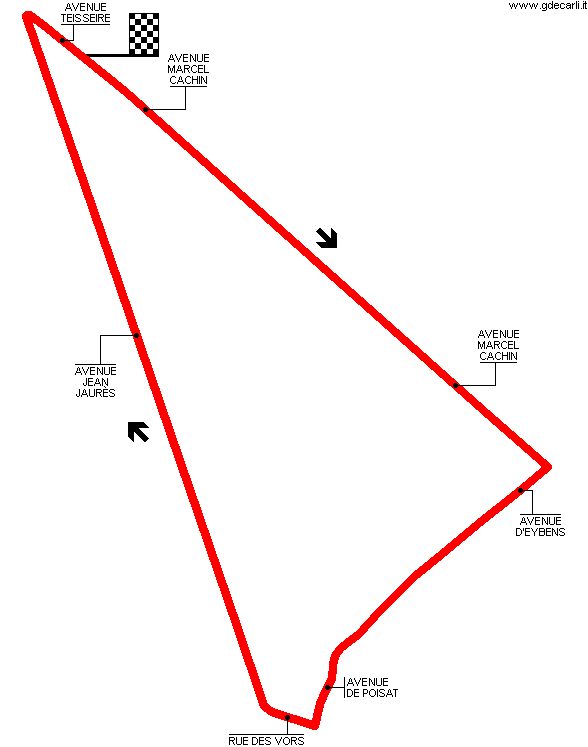
| Distinctive points | Avenue Marcel Cachin - Avenue D’Eybens - Avenue De Poisat - Rue Des Vors - Avenue Jean Jaurès - Avenue Teisseire | ||||
| length | 5300 m | 17388 ft | 3.293 mi | (5) | |
| length | 5310 m | 17421 ft | 3.3 mi | (5) | |
| length | 5307 m | 17411 ft | 3.298 mi | Calculated from aerial photo (*) | (3) |
| Circuit du Dauphiné | |||||
| Description | |||||
| Years | 1947÷1955 | ||||
| Direction | Clockwise | ||||
| Proposal |
NO | ||||
| No longer operational | YES | ||||
| Car Circuit | YES | ||||
| Motorbike circuit | |||||
| Type | Street course | ||||
| Inauguration | July 27th 1947 | ||||
| Closing | May 8th 1955 | ||||
| Last update of this page | December 1st 2009 | ||||
| Info last update | |||||
| Designer | |||||
| Distinctive points | Avenue Marcel Cachin - Avenue Paul Eluard - Rue Monge - Avenue Jean Jaurès - Avenue Teisseire | ||||
| length | 2190 m | 7185 ft | 1.361 mi | (2) | |
| length | 1915 m | 6283 ft | 1.19 mi | Calculated from aerial photo (*) | (4) |
Grenoble, Circuit du Dauphiné (all layouts)
Due to technical problems, temporarily it’s no longer possible to see the circuits on Google Maps embedded in the current page.
This feature will be restored as soon as I figure out how to do (any help would be appreciated!)
See this track layout with Google Earth
(milermeter.com can be used in your browser, without installing anything; Google Earth is a program that must be installed in your computer)
(Map shown here above can show at the same time all eventual layouts drawn. If you want to see only some of them, please go to Google Maps or Google Earth, by clicking on its own link)
Grenoble, Circuit du Dauphiné: 1930÷1931 circuit
Due to technical problems, temporarily it’s no longer possible to see the circuits on Google Maps embedded in the current page.
This feature will be restored as soon as I figure out how to do (any help would be appreciated!)
See this track layout with Google Earth
- milermeter.com
(milermeter.com can be used in your browser, without installing anything; Google Earth is a program that must be installed in your computer)
(Map shown here above can show at the same time all eventual layouts drawn. If you want to see only some of them, please go to Google Maps or Google Earth, by clicking on its own link)
Grenoble, Circuit du Dauphiné: 1947÷1955 circuit
Due to technical problems, temporarily it’s no longer possible to see the circuits on Google Maps embedded in the current page.
This feature will be restored as soon as I figure out how to do (any help would be appreciated!)
See this track layout with Google Earth
- milermeter.com
(milermeter.com can be used in your browser, without installing anything; Google Earth is a program that must be installed in your computer)
(Map shown here above can show at the same time all eventual layouts drawn. If you want to see only some of them, please go to Google Maps or Google Earth, by clicking on its own link)
| Updates | |||||||
| Date | Track layout | Years | Description by | Map by | Thanks to | Note | |
| December 1st 2009 | Guido de Carli | Guido de Carli | Bob Simbel | Update | Description | ||
| November 24th 2007 | Circuit du Dauphiné | 1930÷1931 | Lorenzo Tommasi | Guido de Carli | Update | Map | |
| April 8th 2006 | Circuit du Dauphiné | 1930÷1931 | Guido de Carli | Lorenzo Tommasi | Update | Description | |
| January 11th 2004 | Circuit du Dauphiné | 1930÷1931 | Guido de Carli | New | Description | ||
| Not all eventual updates issued in last years are already visible in this list | |||||||


