| KEN - KENYA | |||||||||||||||||||||
| NAKURU | |||||||||||||||||||||
| Description | Circuit largely disused by 1986, it was still occasionally used as a testing ground through to at least 2002. Now the area is overbuilt. | ||||||||||||||||||||
| Location | Lake Nakuru - Rift Valley | ||||||||||||||||||||
| Location | Lake View Estate area, at bottom of Honeymoon Hill | ||||||||||||||||||||
| Latitude - Longitude (approx) | - 0°19'00" + 36°04'00" (approx) -0.316667 36.066667 (approx) | ||||||||||||||||||||
| UTM Coordinates (approx) | X = 173454.797 - Y = 9964952.549 - Zone 37M (approx) | ||||||||||||||||||||
| Aerial photo / Map (*) |  OpenStreetMap - Google Maps - Bing Maps - Flash Earth - Wikimapia OpenStreetMap - Google Maps - Bing Maps - Flash Earth - Wikimapia | ||||||||||||||||||||
| Altitude AMSL (approx) | 1780 m - 5840 ft (approx) | ||||||||||||||||||||
| Inauguration | February 1956 | ||||||||||||||||||||
| Closing | |||||||||||||||||||||
| Designer | |||||||||||||||||||||
| Sources and links (Translation) (**) |
| ||||||||||||||||||||
| Nakuru | |||||
| Description | |||||
| Years | 1956÷... | ||||
| Direction |  Anticlockwise Anticlockwise | ||||
 Proposal Proposal |
NO | ||||
| No longer operational | YES | ||||
| Car Circuit | YES | ||||
| Motorbike circuit | |||||
| Type | Permanent | ||||
| Inauguration | February 1956 | ||||
| Closing | |||||
| Last update of this page | January 18th 2008 | ||||
| Info last update | |||||
| Designer | |||||
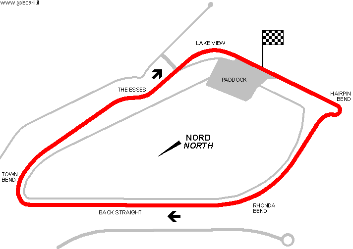
| Distinctive points | Hairpin Bend - Rhoda Bend - Back Straight - Town Bend - The Esses - Lake View | ||||
| length | 2092 m | 6864 ft | 1.3 mi | (2) | |
| length | 2137 m | 7012 ft | 1.328 mi | (3) | |
Nakuru
| Updates | |||||||
| Date | Track layout | Years | Description by | Map by | Thanks to | Note | |
| October 15th 2010 | 1956÷... | Guido de Carli | Guido de Carli | Update | Description with map | ||
| January 18th 2008 | 1956÷... | Guido de Carli | Update | Description | |||
| January 13th 2008 | 1956÷... | Guido de Carli | Update | Description without map | |||
| Not all eventual updates issued in last years are already visible in this list | |||||||


