| USA - UNITED STATES | |||||||||||||
| PHOENIX, BANK ONE PARK BALL (2007) | |||||||||||||
| Not to be confused with | Manzanita Speedway - Phoenix F.1 - Phoenix International Raceway - Phoenix Kart Club | ||||||||||||
| Description | |||||||||||||
| Location | Phoenix AZ - Arizona - Western States | ||||||||||||
| Location | Around the Bank One Ballpark and America West Arena | ||||||||||||
| Latitude - Longitude | + 33°26'39" -112°04'12" 33.444167 -112.07 | ||||||||||||
| UTM Coordinates | X = 400546.604 - Y = 3701040.934 - Zone 12S | ||||||||||||
| Aerial photo / Map (*) |  OpenStreetMap - Google Maps - Bing Maps - Flash Earth - Wikimapia - Microsoft Research Maps - MapQuest OpenStreetMap - Google Maps - Bing Maps - Flash Earth - Wikimapia - Microsoft Research Maps - MapQuest | ||||||||||||
| Altitude AMSL | 330 m - 1083 ft | ||||||||||||
| Inauguration | December 2nd 2007 | ||||||||||||
| Closing | |||||||||||||
| Designer | |||||||||||||
| Sources and links (Translation) (**) |
| ||||||||||||
| (2006/06) | |||||
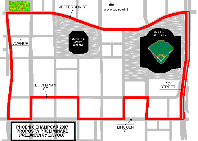
| Description | Proposed street circuit that should host a Champ Car race at the end of 2007 season, probably from November 16th to 18th (later it has been delayed on December 2nd 2007) during Speed Festival. This proposed circuit is in Phoenix town center, around Bank One Park Ball (a sporting area). Map shown here shows preliminary proposal as it was shown by tv3nu television. As it is a preliminary proposal, official track length, direction and start/finish line are not known; length reported here is only approximated. Immediately some problems came out:
Before June 15th 2006 court of first instance gave the reason to ChampCar and to Festival organizators and Phoenix County Council commission gave a temporary consent (County Council have to give final consent) and it allocated 15 million US Dollard for next Festival and 8 million US Dollars a year for next years. | ||||
| Years | 2007 | ||||
| Direction |  Clockwise Clockwise | ||||
 Proposal Proposal |
YES
| ||||
| Proposal not developed | |||||
| Car Circuit | YES | ||||
| Motorbike circuit | |||||
| Type | Street course | ||||
| Inauguration | |||||
| Closing | |||||
| Last update of this page | June 16th 2006 | ||||
| Info last update | June 15th 2006 | ||||
| Designer | |||||
| Distinctive points | 7th Street - Lincoln Street - Buchanan Street - 1st Avenue - Jefferson Street | ||||
| length (approx) | 3380 m | 11088 ft | 2.1 mi | Approximated length | |
| (2006/08) | |||||
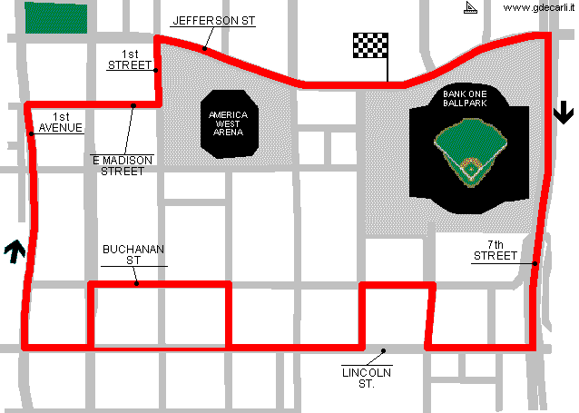
| Description | On August 6th 2006 official website was opened and organizators revealed first official layout of the track: it’s not too different from preliminary unofficial draft issued last June, but there are a couple of news:
| ||||
| Years | 2007 | ||||
| Direction | Clockwise | ||||
| Proposal |
YES
| ||||
| Proposal not developed | YES | ||||
| Car Circuit | YES | ||||
| Motorbike circuit | |||||
| Type | Street course | ||||
| Inauguration | |||||
| Closing | |||||
| Last update of this page | September 13th 2006 | ||||
| Info last update | August 6th 2006 | ||||
| Designer | |||||
| Distinctive points | Jefferson Street - 7th Street - Lincoln Street - Buchanan Street - 1st Avenue - East Madison Street - 1st Street | ||||
| length (approx) | 3380 m | 11088 ft | 2.1 mi | Approximated length | |
| (2006/11) | |||||
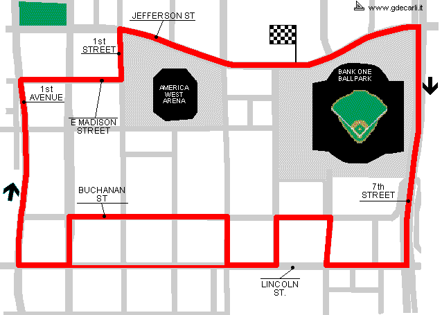
| Description | New layout for the track layout, dated november 2006 | ||||
| Years | 2007 | ||||
| Direction | Clockwise | ||||
| Proposal |
YES
| ||||
| Proposal not developed | YES | ||||
| Car Circuit | YES | ||||
| Motorbike circuit | |||||
| Type | Street course | ||||
| Inauguration | |||||
| Closing | |||||
| Last update of this page | January 21st 2007 | ||||
| Info last update | September 2007 | ||||
| Designer | |||||
| Distinctive points | |||||
Preliminary unofficial proposal - June 2006
Due to technical problems, temporarily it’s no longer possible to see the circuits on Google Maps embedded in the current page.
This feature will be restored as soon as I figure out how to do (any help would be appreciated!)
See this track layout with Google Earth
(milermeter.com can be used in your browser, without installing anything; Google Earth is a program that must be installed in your computer)
(Map shown here above can show at the same time all eventual layouts drawn. If you want to see only some of them, please go to Google Maps or Google Earth, by clicking on its own link)
First official Layout - August 2006
Due to technical problems, temporarily it’s no longer possible to see the circuits on Google Maps embedded in the current page.
This feature will be restored as soon as I figure out how to do (any help would be appreciated!)
See this track layout with Google Earth
(milermeter.com can be used in your browser, without installing anything; Google Earth is a program that must be installed in your computer)
(Map shown here above can show at the same time all eventual layouts drawn. If you want to see only some of them, please go to Google Maps or Google Earth, by clicking on its own link)
November 2006 modified layout
Due to technical problems, temporarily it’s no longer possible to see the circuits on Google Maps embedded in the current page.
This feature will be restored as soon as I figure out how to do (any help would be appreciated!)
See this track layout with Google Earth
(milermeter.com can be used in your browser, without installing anything; Google Earth is a program that must be installed in your computer)
(Map shown here above can show at the same time all eventual layouts drawn. If you want to see only some of them, please go to Google Maps or Google Earth, by clicking on its own link)
| Updates | |||||||
| Date | Track layout | Years | Description by | Map by | Thanks to | Note | |
| September 5th 2007 | Lorenzo Tommasi | Update | Description | ||||
| May 19th 2007 | Lorenzo Tommasi | Update | Map | ||||
| January 21st 2007 | (2006/11) | 2007 | Guido de Carli | ||||
| September 5th 2006 | Lorenzo Tommasi | Update | Description | ||||
| June 22nd 2006 | Guido de Carli | Update | Description | ||||
| June 16th 2006 | Guido de Carli | Guido de Carli | Lorenzo Tommasi | New | Description with map | ||
| Not all eventual updates issued in last years are already visible in this list | |||||||


