| FRA - FRANCE | |||||||||
| LA BAULE, AERODROME | |||||||||
| Not to be confused with | La Baule | ||||||||
| Description | Circuit used in 1950s. Sources reports it was at Saint-Nazaire, but this village is approx 8 km - 5 mi east of the airfield, so I don’t knoe if it is the same track or if there were two different | ||||||||
| Location | La Baule-Escoublac 44 - Loire-Atlantique - Pays de la Loire | ||||||||
| Location | Aerodrome Escoublac La Boule | ||||||||
| Latitude - Longitude | + 47°17'13" - 2°20'54" 47.286944 -2.348333 | ||||||||
| UTM Coordinates | X = 549277.407 - Y = 5237257.868 - Zone 30T | ||||||||
| Aerial photo / Map (*) |  OpenStreetMap - Google Maps - Bing Maps - Flash Earth - Wikimapia - GéoPortail OpenStreetMap - Google Maps - Bing Maps - Flash Earth - Wikimapia - GéoPortail | ||||||||
| Altitude AMSL | 25 m - 82 ft | ||||||||
| Inauguration | |||||||||
| Closing | |||||||||
| Designer | |||||||||
| Sources and links (Translation) (**) |
| ||||||||
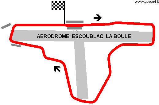
| Aerodrome Escoublac La Boule (Saint-Nazaire) | |||||
| Description | |||||
| Years | 195x | ||||
| Direction |  Clockwise Clockwise | ||||
 Proposal Proposal |
NO | ||||
| No longer operational | YES | ||||
| Car Circuit | YES | ||||
| Motorbike circuit | |||||
| Type | Airfield course | ||||
| Inauguration | |||||
| Closing | |||||
| Last update of this page | December 1st 2008 | ||||
| Info last update | |||||
| Designer | |||||
| Distinctive points | |||||
| length | 4260 m | 13976 ft | 2.647 mi | (1) | |
| length | 4264 m | 13990 ft | 2.65 mi | (2) | |
La Baule, Aerodrome
| Updates | |||||||
| Date | Track layout | Years | Description by | Map by | Thanks to | Note | |
| December 1st 2008 | Guido de Carli | Update | Description | ||||
| Not all eventual updates issued in last years are already visible in this list | |||||||


