| FRA - FRANCE | |||||||||||||||||||||
| LES SABLES-D’OLONNE | |||||||||||||||||||||
| Not to be confused with | Puits d’Enfer | ||||||||||||||||||||
| Description | Street track used in two different layouts from 1951 to 1956 | ||||||||||||||||||||
| Location | Les Sables-d’Olonne 85 - Vendée - Pays de la Loire | ||||||||||||||||||||
| Location | Les Sables d’Olonne town center, between Nantes and La Rochelle | ||||||||||||||||||||
| Latitude - Longitude | + 46°29'05" - 1°45'39" 46.484722 -1.760833 | ||||||||||||||||||||
| UTM Coordinates | X = 595109.879 - Y = 5148651.638 - Zone 30T | ||||||||||||||||||||
| Aerial photo / Map (*) |  OpenStreetMap - Google Maps - Bing Maps - Flash Earth - Wikimapia - GéoPortail OpenStreetMap - Google Maps - Bing Maps - Flash Earth - Wikimapia - GéoPortail | ||||||||||||||||||||
| Altitude AMSL | 17 m - 56 ft | ||||||||||||||||||||
| Inauguration | 1951 | ||||||||||||||||||||
| Closing | 1956 | ||||||||||||||||||||
| Designer | |||||||||||||||||||||
| Sources and links (Translation) (**) |
| ||||||||||||||||||||
| Les Sables-d’Olonne | |||||
| Description | |||||
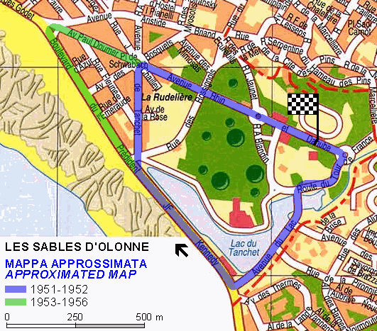
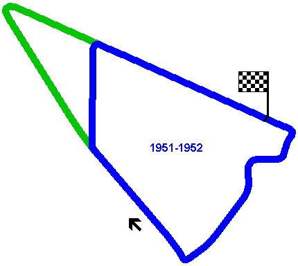
| Years | 1951÷1952 | ||||
| Direction |  Clockwise Clockwise | ||||
 Proposal Proposal |
NO | ||||
| No longer operational | YES | ||||
| Car Circuit | YES | ||||
| Motorbike circuit | |||||
| Type | Street course | ||||
| Inauguration | 1951 | ||||
| Closing | 1952 | ||||
| Last update of this page | August 30th 2009 | ||||
| Info last update | |||||
| Designer | |||||
| Distinctive points | Avenue Rhin et Danube - Route du Tour - Avenue du Lac - Boulevard du President J.F. Kennedy - Avenue de Tanchet - Place de Schwabach | ||||
| length | 2277 m | 7470 ft | 1.415 mi | (2) | |
| length | 2405 m | 7892 ft | 1.495 mi | Calculated from aerial photo (*) | (4) |
| Les Sables-d’Olonne | |||||
| Description | |||||
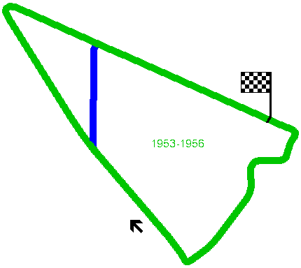
| Years | 1953÷1956 | ||||
| Direction | Clockwise | ||||
| Proposal |
NO | ||||
| No longer operational | YES | ||||
| Car Circuit | YES | ||||
| Motorbike circuit | |||||
| Type | Street course | ||||
| Inauguration | 1953 | ||||
| Closing | 1956 | ||||
| Last update of this page | August 30th 2009 | ||||
| Info last update | |||||
| Designer | |||||
| Distinctive points | Avenue Rhin et Danube - Route du Tour - Avenue du Lac - Boulevard du President J.F. Kennedy - Avenue Paul Doumer - Place de Schwabach | ||||
| length | 2980 m | 9777 ft | 1.852 mi | (2) | |
| length | 2985 m | 9794 ft | 1.855 mi | Calculated from aerial photo (*) | (3) |
Les Sables-d’Olonne
Les Sables-d’Olonne 1951÷1952
Due to technical problems, temporarily it’s no longer possible to see the circuits on Google Maps embedded in the current page.
This feature will be restored as soon as I figure out how to do (any help would be appreciated!)
See this track layout with Google Earth
- milermeter.com
(milermeter.com can be used in your browser, without installing anything; Google Earth is a program that must be installed in your computer)
(Map shown here above can show at the same time all eventual layouts drawn. If you want to see only some of them, please go to Google Maps or Google Earth, by clicking on its own link)
Les Sables-d’Olonne 1953÷1956
Due to technical problems, temporarily it’s no longer possible to see the circuits on Google Maps embedded in the current page.
This feature will be restored as soon as I figure out how to do (any help would be appreciated!)
See this track layout with Google Earth
- milermeter.com
(milermeter.com can be used in your browser, without installing anything; Google Earth is a program that must be installed in your computer)
(Map shown here above can show at the same time all eventual layouts drawn. If you want to see only some of them, please go to Google Maps or Google Earth, by clicking on its own link)
| Updates | |||||||
| Date | Track layout | Years | Description by | Map by | Thanks to | Note | |
| August 30th 2009 | Guido de Carli | Roelard Smit | Roelard Smit | Update | Description with map | ||
| August 30th 2009 | Guido de Carli | Roelard Smit | New | Photos (link) | |||
| July 17th 2003 | Guido de Carli | Guido de Carli | New | Description with map | |||
| July 16th 2003 | Guido de Carli | New | Description | ||||
| August 19th 2002 | Guido de Carli | Update | Description | ||||
| Not all eventual updates issued in last years are already visible in this list | |||||||


