| BRA - BRAZIL | |||||||||||||||||||||
| BARRA DA TIJUCA, GUANABARA | |||||||||||||||||||||
| Not to be confused with | Barra da Tijuca, Kartodromo do Shopping - Boa Vista - Fundão, Cidade Universitária - Jacarepaguá (Nelson Piquet & Emerson Fittipaldi) (ex Barra da Tijuca) - Rio de Janeiro (Formula E) - Rio de Janeiro, Deodoro | ||||||||||||||||||||
| Description | |||||||||||||||||||||
| Location | Barra da Tijuca RJ - Rio de Janeiro - Região Sudeste | ||||||||||||||||||||
| Location | In Rio de Janeiro Southern area, approx 10 km - 6 mi South East of Jacarepaguà and approx 16 km - 10 mi South West of Sugarloaf Mountain (Pão de Açúcar) and Copacabana | ||||||||||||||||||||
| Latitude - Longitude | - 23°00'39" - 43°18'33" -23.010833 -43.309167 | ||||||||||||||||||||
| UTM Coordinates | X = 673282.903 - Y = 7454281.345 - Zone 23K | ||||||||||||||||||||
| Aerial photo / Map (*) |  OpenStreetMap - Google Maps - Bing Maps - Flash Earth - Wikimapia OpenStreetMap - Google Maps - Bing Maps - Flash Earth - Wikimapia | ||||||||||||||||||||
| Altitude AMSL | |||||||||||||||||||||
| Inauguration | 1958 | ||||||||||||||||||||
| Closing | 1970 | ||||||||||||||||||||
| Designer | |||||||||||||||||||||
| Sources and links (Translation) (**) |
| ||||||||||||||||||||
| Circuito Internacional da Guanabara | |||||
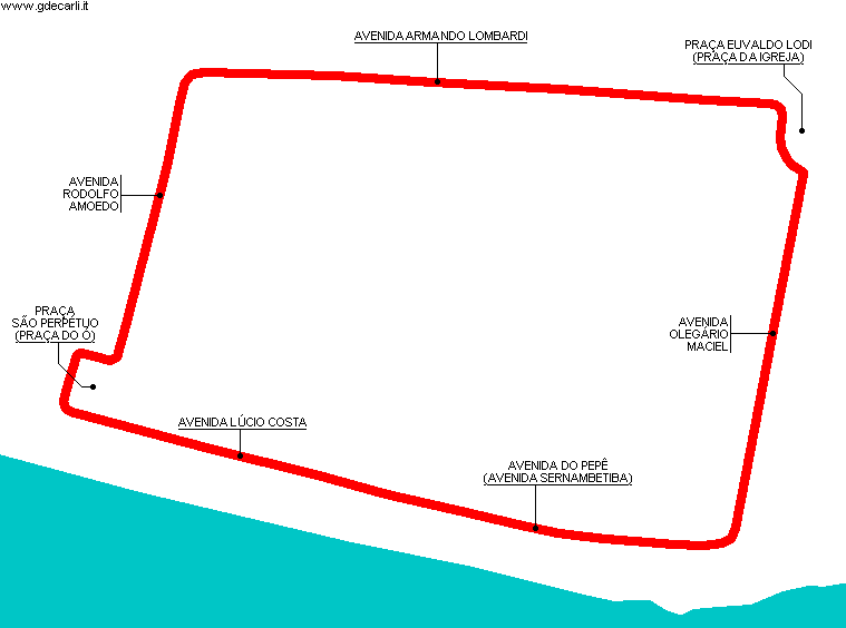
| Description | Start/finish line (not drawn on my map) was in Avenida Armando Lombardi | ||||
| Years | |||||
| Direction |  Anticlockwise Anticlockwise | ||||
 Proposal Proposal |
NO | ||||
| No longer operational | YES | ||||
| Car Circuit | YES | ||||
| Motorbike circuit | |||||
| Type | Street course | ||||
| Inauguration | 1958 | ||||
| Closing | 1970 | ||||
| Last update of this page | March 11th 2009 | ||||
| Info last update | |||||
| Designer | |||||
| Distinctive points | Avenida Armando Lombardi - Avenida Rodolfo Amoedo - Praça São Perpétuo (Praça do Ó) - Avenida Lúcio Costa - Avenida do Pepê (Avenida Sernambetiba) - Avenida Olegário Maciel - Praça Euvaldo Lodi (Praça da Igreja) | ||||
| length | 4285 m | 14058 ft | 2.663 mi | (5) | |
| length | 4193 m | 13757 ft | 2.606 mi | Calculated from aerial photo (*) | (2) |
Barra da Tijuca, Guanabara
Due to technical problems, temporarily it’s no longer possible to see the circuits on Google Maps embedded in the current page.
This feature will be restored as soon as I figure out how to do (any help would be appreciated!)
See this track layout with Google Earth
- milermeter.com
(milermeter.com can be used in your browser, without installing anything; Google Earth is a program that must be installed in your computer)
(Map shown here above can show at the same time all eventual layouts drawn. If you want to see only some of them, please go to Google Maps or Google Earth, by clicking on its own link)
| Updates | |||||||
| Date | Track layout | Years | Description by | Map by | Thanks to | Note | |
| March 11th 2009 | Circuito Internacional da Guanabara | Guido de Carli | Guido de Carli | Update | Description with map | ||
| December 7th 2007 | Circuito Internacional da Guanabara | Guido de Carli | Guido de Carli | Lorenzo Tommasi | New | Description with map | |
| Not all eventual updates issued in last years are already visible in this list | |||||||


