| ARG - ARGENTINA | |||||||||||||||||||||
| MENDOZA, PARQUE GENERAL SAN MARTÍN | |||||||||||||||||||||
| Not to be confused with | Mendoza, Autódromo General San Martín | ||||||||||||||||||||
| Description | Not to be confused with Autódromo General San Martín built few years later | ||||||||||||||||||||
| Location | Mendoza M - Mendoza - Nuevo Cuyo | ||||||||||||||||||||
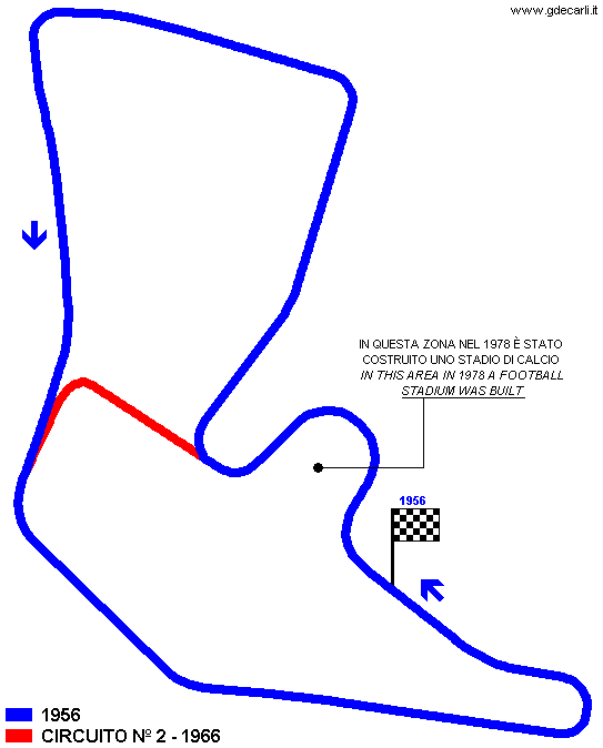
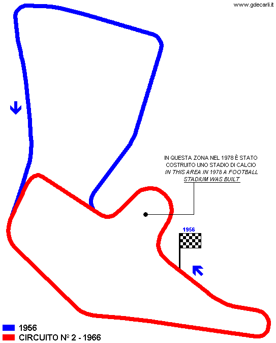
| Location | General San Martín Park, in western part of Mendoza, approx. 3 km - 2 mi East of Autódromo General San Martín. In the area just after start line, in 1978 was built a football stadium, so this section of the track doen’t exist anymore. | ||||||||||||||||||||
| Latitude - Longitude | - 32°53'21" - 68°52'49" -32.889167 -68.880278 | ||||||||||||||||||||
| UTM Coordinates | X = 511197.896 - Y = 6360993.551 - Zone 19H | ||||||||||||||||||||
| Aerial photo / Map (*) |  OpenStreetMap - Google Maps - Bing Maps - Flash Earth - Wikimapia OpenStreetMap - Google Maps - Bing Maps - Flash Earth - Wikimapia | ||||||||||||||||||||
| Altitude AMSL | 845 m - 2772 ft | ||||||||||||||||||||
| Inauguration | February 5th 1956 | ||||||||||||||||||||
| Closing | |||||||||||||||||||||
| Designer | |||||||||||||||||||||
| Sources and links (Translation) (**) |
| ||||||||||||||||||||
| General San Martín | |||||
| Description | Road circuit used at list for Formula Libre Premio Ciudad de Buenos Aires (even if it not in Buenos Aires!) on February 5th 1956. I don’t know if this layout has been used some more times, surely at least in 1966 a shorter one was used. | ||||
| Years | 1956 | ||||
| Direction |  Anticlockwise Anticlockwise | ||||
 Proposal Proposal |
NO | ||||
| No longer operational | YES | ||||
| Car Circuit | YES | ||||
| Motorbike circuit | |||||
| Type | Street course | ||||
| Inauguration | February 5th 1956 | ||||
| Closing | February 5th 1956 | ||||
| Last update of this page | January 23rd 2008 | ||||
| Info last update | |||||
| Designer | |||||
| Distinctive points | Avenida El Libertador - Camino de la Virgen | ||||
| length | 4184 m | 13728 ft | 2.6 mi | (4) | |
| length | 4184 m | 13727 ft | 2.6 mi | (3) | |
| General San Martín - Circuito 2 | |||||
| Description | Street circuit used at list for Gran Premio Internacional Yacimentos Petroliferos Fiscales on February 6th 1966. I don’t know if start/finish line was in the same position as in 1956, neither if direction was again anticlockwise. Moreover, I don’t know if this layout has been used some more times, surely at least in 1956 a longer one was used. | ||||
| Years | 1966 | ||||
| Direction | Anticlockwise | ||||
| Proposal |
NO | ||||
| No longer operational | YES | ||||
| Car Circuit | YES | ||||
| Motorbike circuit | |||||
| Type | Street course | ||||
| Inauguration | |||||
| Closing | |||||
| Last update of this page | November 11th 2004 | ||||
| Info last update | |||||
| Designer | |||||
| Distinctive points | Camino de la Virgen | ||||
| length | 2644.7 m | 8677 ft | 1.643 mi | (2) | |
Mendoza - General San Martín 1956
Mendoza - General San Martín 1966
| Updates | |||||||
| Date | Track layout | Years | Description by | Map by | Thanks to | Note | |
| January 23rd 2008 | Guido de Carli | Update | Description | ||||
| November 13th 2004 | General San Martín | 1956 | Guido de Carli | Guido de Carli | New | Description with map | |
| November 13th 2004 | General San Martín - Circuito 2 | 1966 | Guido de Carli | Guido de Carli | New | Description with map | |
| November 11th 2004 | General San Martín - Circuito 2 | 1966 | Guido de Carli | New | Description | ||
| Not all eventual updates issued in last years are already visible in this list | |||||||


