| CZE - CZECH REPUBLIC | |||||||||
| BRNO BVV | |||||||||
| Not to be confused with | Brno (1972) - Brno, Masaryk Circuit - Brno, Masaryk Circuit (autodrom) | ||||||||
| Description | Circuit used for Formula Junior and Eastern European Peace & Friendship Cup. | ||||||||
| Location | Brno B - Jihomoravský kraj - Jihovýchod | ||||||||
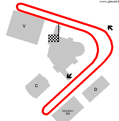
| Location | Around Brno Exhibition Centre pavillions (Veletrhy Brno) | ||||||||
| Latitude - Longitude | + 49°11'16" + 16°35'00" 49.187778 16.583333 | ||||||||
| UTM Coordinates | X = 615370.869 - Y = 5449537.159 - Zone 33U | ||||||||
| Aerial photo / Map (*) |  OpenStreetMap - Google Maps - Bing Maps - Flash Earth - Wikimapia - Mapy.cz OpenStreetMap - Google Maps - Bing Maps - Flash Earth - Wikimapia - Mapy.cz | ||||||||
| Altitude AMSL | 207 m - 679 ft | ||||||||
| Inauguration | 1964 | ||||||||
| Closing | 1962 | ||||||||
| Designer | |||||||||
| Sources and links (Translation) (**) |
| ||||||||
| Brno BVV | |||||
| Description | |||||
| Years | 1964÷1965 | ||||
| Direction |  Anticlockwise Anticlockwise | ||||
 Proposal Proposal |
NO | ||||
| No longer operational | YES | ||||
| Car Circuit | YES | ||||
| Motorbike circuit | |||||
| Type | Street course | ||||
| Inauguration | 1964 | ||||
| Closing | December 31st 1965 | ||||
| Last update of this page | February 10th 2008 | ||||
| Info last update | |||||
| Designer | |||||
| Distinctive points | |||||
| length | 1700 m | 5577 ft | 1.056 mi | (1) | |
| length | 1500 m | 4921 ft | 0.932 mi | to be verified | (1) |
| length | 1605 m | 5267 ft | 0.998 mi | Calculated from aerial photo (*) | (2) |
Brno BVV
Due to technical problems, temporarily it’s no longer possible to see the circuits on Google Maps embedded in the current page.
This feature will be restored as soon as I figure out how to do (any help would be appreciated!)
See this track layout with Google Earth
- milermeter.com
(milermeter.com can be used in your browser, without installing anything; Google Earth is a program that must be installed in your computer)
(Map shown here above can show at the same time all eventual layouts drawn. If you want to see only some of them, please go to Google Maps or Google Earth, by clicking on its own link)
| Updates | |||||||
| Date | Track layout | Years | Description by | Map by | Thanks to | Note | |
| November 6th 2008 | 1964÷1965 | Guido de Carli | Vasco | Vasco | Update | Map | |
| February 10th 2008 | 1964÷1965 | Guido de Carli | Guido de Carli | David Griac (jpm) | New | Description with map | |
| Not all eventual updates issued in last years are already visible in this list | |||||||


