| GER - GERMANY | |||||||||||||
| FELDBERGRING (FELDBERGRENNEN) | |||||||||||||
| Description | Street circuit used for car races (1950) and motorcycle races (1950-1954). I have no more news. | ||||||||||||
| Location | Taunus HE - Hessen - 1949÷1990: BRD | ||||||||||||
| Location | On Taunus hills, few km North West of Frankfurt am Main (Hessen) | ||||||||||||
| Latitude - Longitude | + 50°14'37" + 8°26'45" 50.243611 8.445833 | ||||||||||||
| UTM Coordinates | X = 460485.629 - Y = 5565863.968 - Zone 32U | ||||||||||||
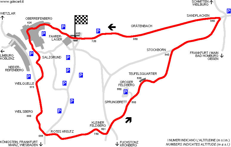
| Aerial photo / Map (*) |  OpenStreetMap - Google Maps - Bing Maps - Flash Earth - Wikimapia - GoYellow.de OpenStreetMap - Google Maps - Bing Maps - Flash Earth - Wikimapia - GoYellow.de | ||||||||||||
| Altitude AMSL | 940 m - 3084 ft | ||||||||||||
| Inauguration | 1950 | ||||||||||||
| Closing | 1954 | ||||||||||||
| Designer | |||||||||||||
| Sources and links (Translation) (**) |
| ||||||||||||
| Feldbergring (Feldbergrennen) | |||||
| Description | |||||
| Years | 1950÷1954 | ||||
| Direction |  Anticlockwise Anticlockwise | ||||
 Proposal Proposal |
NO | ||||
| No longer operational | YES | ||||
| Car Circuit | YES | ||||
| Motorbike circuit | YES | ||||
| Type | Road course | ||||
| Inauguration | 1950 | ||||
| Closing | 1954 | ||||
| Last update of this page | September 10th 2007 | ||||
| Info last update | |||||
| Designer | |||||
| Distinctive points | |||||
| length | 11576 m | 37979 ft | 7.193 mi | (1) | |
| length | 11466 m | 37618 ft | 7.125 mi | Calculated from aerial photo (*) | (3) |
| Difference in level | 365 m | 1198 ft | 0.227 mi | (1) | |
Feldbergring (Feldbergrennen)
Due to technical problems, temporarily it’s no longer possible to see the circuits on Google Maps embedded in the current page.
This feature will be restored as soon as I figure out how to do (any help would be appreciated!)
See this track layout with Google Earth
- milermeter.com
(milermeter.com can be used in your browser, without installing anything; Google Earth is a program that must be installed in your computer)
(Map shown here above can show at the same time all eventual layouts drawn. If you want to see only some of them, please go to Google Maps or Google Earth, by clicking on its own link)
| ALTITUDE | ||||||||||||||||||||||||||||||||||||||||||||
| ||||||||||||||||||||||||||||||||||||||||||||
| Updates | |||||||
| Date | Track layout | Years | Description by | Map by | Thanks to | Note | |
| July 14th 2009 | 1950÷1954 | Guido de Carli | Peer Risch | Peer Risch | Update | Description with map | |
| November 25th 2005 | 1950÷1954 | Guido de Carli | Guido de Carli | Martin Berrang | Update | Description with map | |
| November 12th 2005 | 1950÷1954 | Guido de Carli | Martin Berrang | New | Description | ||
| Not all eventual updates issued in last years are already visible in this list | |||||||


