| GER - GERMANY | |||||||||||||||||||||||||||||||||||||||||||||||||||||||||||||||||||||||||||||
| SACHSENRING HOHENSTEIN-ERNSSTHAL | |||||||||||||||||||||||||||||||||||||||||||||||||||||||||||||||||||||||||||||
| SORRY, SOME DATA ARE NOT TRANSLATED YET | |||||||||||||||||||||||||||||||||||||||||||||||||||||||||||||||||||||||||||||
| Not to be confused with | Grillenburg (Sachsenring) | ||||||||||||||||||||||||||||||||||||||||||||||||||||||||||||||||||||||||||||
| Description | |||||||||||||||||||||||||||||||||||||||||||||||||||||||||||||||||||||||||||||
| Location | Hohenstein-Ernssthal SN - Sachsen - 1949÷1990: DDR | ||||||||||||||||||||||||||||||||||||||||||||||||||||||||||||||||||||||||||||
| Location | |||||||||||||||||||||||||||||||||||||||||||||||||||||||||||||||||||||||||||||
| Latitude - Longitude | + 50°47'31" + 12°41'20" 50.791944 12.688889 | ||||||||||||||||||||||||||||||||||||||||||||||||||||||||||||||||||||||||||||
| UTM Coordinates | X = 337114.912 - Y = 5629234.797 - Zone 33U | ||||||||||||||||||||||||||||||||||||||||||||||||||||||||||||||||||||||||||||
| Aerial photo / Map (*) |  OpenStreetMap - Google Maps - Bing Maps - Flash Earth - Wikimapia - GoYellow.de OpenStreetMap - Google Maps - Bing Maps - Flash Earth - Wikimapia - GoYellow.de | ||||||||||||||||||||||||||||||||||||||||||||||||||||||||||||||||||||||||||||
| Altitude AMSL | |||||||||||||||||||||||||||||||||||||||||||||||||||||||||||||||||||||||||||||
| Inauguration | 1927 | ||||||||||||||||||||||||||||||||||||||||||||||||||||||||||||||||||||||||||||
| Closing | |||||||||||||||||||||||||||||||||||||||||||||||||||||||||||||||||||||||||||||
| Designer | |||||||||||||||||||||||||||||||||||||||||||||||||||||||||||||||||||||||||||||
| Sources and links (Translation) (**) |
| ||||||||||||||||||||||||||||||||||||||||||||||||||||||||||||||||||||||||||||
| Hohenstein-Ernssthal | |||||
| Description | |||||
| Years | 1927÷1972 | ||||
| Direction |  Anticlockwise Anticlockwise | ||||
 Proposal Proposal |
NO | ||||
| No longer operational | YES | ||||
| Car Circuit | |||||
| Motorbike circuit | |||||
| Type | Road course | ||||
| Inauguration | 1927 | ||||
| Closing | 1972 | ||||
| Last update of this page | January 16th 2008 | ||||
| Info last update | |||||
| Designer | |||||
| Distinctive points | Queckenberg - Heiterer Blick - Jugend - MTS Kurve - Bodberg | ||||
| length | 8618 m | 28274 ft | 5.355 mi | (8) | |
| length | 8730 m | 28642 ft | 5.425 mi | (10) | |
| length | 8731 m | 28645 ft | 5.425 mi | (14) | |
| Hohenstein-Ernssthal | |||||
| Description | |||||
| Years | 1990 | ||||
| Direction | Anticlockwise | ||||
| Proposal |
NO | ||||
| No longer operational | YES | ||||
| Car Circuit | |||||
| Motorbike circuit | |||||
| Type | Road course | ||||
| Inauguration | 1990 | ||||
| Closing | 1990 | ||||
| Last update of this page | January 16th 2008 | ||||
| Info last update | |||||
| Designer | |||||
| Distinctive points | Queckenberg - Heiterer Blick - Jugend - MTS Kurve - Bodberg | ||||
| length | 8740 m | 28675 ft | 5.431 mi | (10) | |
| Sachsenring | |||||
| Description | Motorbike layout has one more chicane, not used by cars | ||||
| Years | 1996÷1997 | ||||
| Direction | Anticlockwise | ||||
| Proposal |
NO | ||||
| No longer operational | YES | ||||
| Car Circuit | YES | ||||
| Motorbike circuit | YES | ||||
| Type | Permanent | ||||
| Inauguration | March 1st 1996 | ||||
| Closing | 1997 | ||||
| Last update of this page | January 16th 2008 | ||||
| Info last update | |||||
| Designer | |||||
| Distinctive points | Coca Cola Kurve - Castrol Omega - Stern Quell | ||||
| length | 3517 m | 11539 ft | 2.185 mi | (4) | |
| length | 3517 m | 11539 ft | 2.185 mi | Motorcycle Circuit | (10) |
| length | 3517 m | 11539 ft | 2.185 mi | Car Circuit | (10) |
| Sachsenring | |||||
| Description | |||||
| Years | 1998÷1999 | ||||
| Direction | Anticlockwise | ||||
| Proposal |
NO | ||||
| No longer operational | YES | ||||
| Car Circuit | YES | ||||
| Motorbike circuit | YES | ||||
| Type | Permanent | ||||
| Inauguration | 1998 | ||||
| Closing | 1999 | ||||
| Last update of this page | January 16th 2008 | ||||
| Info last update | |||||
| Designer | |||||
| Distinctive points | Coca Cola Kurve - Castrol Omega - Stern Quell | ||||
| length | 3442 m | 11293 ft | 2.139 mi | (4) | |
| length | 3508 m | 11509 ft | 2.18 mi | (10) | |
| length | 3508 m | 11509 ft | 2.18 mi | (2) | |
| Straight length | 560 m | 1837 ft | 0.348 mi | (2) | |
| Sachsenring | |||||
| Description | |||||
| Years | 2000 | ||||
| Direction | Anticlockwise | ||||
| Proposal |
NO | ||||
| No longer operational | YES | ||||
| Car Circuit | YES | ||||
| Motorbike circuit | YES | ||||
| Type | Permanent | ||||
| Inauguration | 2000 | ||||
| Closing | 2000 | ||||
| Last update of this page | January 16th 2008 | ||||
| Info last update | |||||
| Designer | |||||
| Distinctive points | Coca Cola Kurve - Castrol Omega - Stern Quell | ||||
| length | 3386 m | 11109 ft | 2.104 mi | (4) | |
| length | 3386 m | 11109 ft | 2.104 mi | (10) | |
| length | 3508 m | 11509 ft | 2.18 mi | (2) | |
| Sachsenring | |||||
| Description | |||||
| Years | 2001÷2002 | ||||
| Direction | Anticlockwise | ||||
| Proposal |
NO | ||||
| No longer operational | YES | ||||
| Car Circuit | YES | ||||
| Motorbike circuit | YES | ||||
| Type | Permanent | ||||
| Inauguration | 2001 | ||||
| Closing | 2002 | ||||
| Last update of this page | January 16th 2008 | ||||
| Info last update | |||||
| Designer | |||||
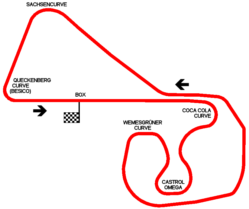
| Distinctive points | Coca Cola Curve - Castrol Omega - Wemesgrüner Curve / Stern Quell - Zwischenzet - Sachsencurve - Queckenberg Curve (Besico) | ||||
| length | 3704 m | 12152 ft | 2.302 mi | (10) | |
| length | 3704.59 m | 12154 ft | 2.302 mi | (18) | |
| Sachsenring | |||||
| Description | |||||
| Years | 2003÷... | ||||
| Direction | Anticlockwise | ||||
| Proposal |
NO | ||||
| No longer operational | |||||
| Car Circuit | YES | ||||
| Motorbike circuit | YES | ||||
| Type | Permanent | ||||
| Inauguration | 2003 | ||||
| Closing | |||||
| Last update of this page | January 16th 2008 | ||||
| Info last update | |||||
| Designer | |||||
| Distinctive points | Coca Cola Curve - Castrol Omega - Wemesgrüner Curve / Stern Quell - Zwischenzet - Sachsencurve - Queckenberg Curve (Besico) | ||||
| length | 3670.59 m | 12043 ft | 2.281 mi | (19) | |
| Width | 14 m | 46 ft | Start finish straight | (19) | |
| Min width | 12 m | 39 ft | (19) | ||
| Max width | 20 m | 66 ft | (19) | ||
| Straight length | 780 m | 2559 ft | 0.485 mi | Start finish straight | (19) |
| Max. gradient (uphill) | 10 % | 5.7 ° | (19) | ||
| Max. gradient (downhill) | 12.8 % | 7.3 ° | (19) | ||
| Total area | 44 hectares | 440000 m² | 108.725 acres | (19) | |
Sachsenring 2001÷2002 (layout used from 2003 is nearly the same)
| Updates | |||||||
| Date | Track layout | Years | Description by | Map by | Thanks to | Note | |
| May 10th 2011 | Hohenstein-Ernssthal | 1927÷1972 | Guido de Carli | micap | Update | Description | |
| December 30th 2010 | Guido de Carli | Update | Description | ||||
| April 8th 2008 | Guido de Carli | Update | Description | ||||
| January 22nd 2008 | Guido de Carli | Michele Capozzolo | Update | Description | |||
| January 16th 2008 | Guido de Carli | Update | Description | ||||
| May 21st 2006 | Sachsenring | 2001÷2002 | Guido de Carli | whrphlio | Update | Description | |
| March 17th 2006 | Hohenstein-Ernssthal | 1927÷1972 | Guido de Carli | Roelard Smit | New | Description | |
| March 11th 2006 | Sachsenring | 2001÷2002 | Guido de Carli | Lorenzo Tommasi | Update | Description | |
| March 11th 2006 | Sachsenring | 1996÷1997 | Guido de Carli | Lorenzo Tommasi | Update | Description | |
| March 11th 2006 | Hohenstein-Ernssthal | 1927÷1972 | Guido de Carli | Lorenzo Tommasi | New | Description | |
| September 10th 2002 | Guido de Carli | Guido de Carli | New | Description with map | |||
| Not all eventual updates issued in last years are already visible in this list | |||||||


