| THA - THAILAND | |||||||||
| KAENG KRACHAN | |||||||||
| Description | |||||||||
| Location | Kaeng Krachan - Phetchaburi - Centro / Central | ||||||||
| Location | |||||||||
| Latitude - Longitude | + 12°56'31" + 99°42'25" 12.941944 99.706944 | ||||||||
| UTM Coordinates | X = 576681.513 - Y = 1430821.496 - Zone 47P | ||||||||
| Aerial photo / Map (*) |  OpenStreetMap - Google Maps - Bing Maps - Flash Earth - Wikimapia OpenStreetMap - Google Maps - Bing Maps - Flash Earth - Wikimapia | ||||||||
| Altitude AMSL | 86 m - 282 ft | ||||||||
| Inauguration | |||||||||
| Closing | |||||||||
| Designer | |||||||||
| Sources and links (Translation) (**) |
| ||||||||
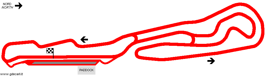
| Kaeng Krachan Circuit | |||||
| Description | |||||
| Years | |||||
| Direction |  Anticlockwise Anticlockwise | ||||
 Proposal Proposal |
NO | ||||
| No longer operational | |||||
| Car Circuit | YES | ||||
| Motorbike circuit | YES | ||||
| Type | Permanent | ||||
| Inauguration | |||||
| Closing | |||||
| Last update of this page | June 24th 2009 | ||||
| Info last update | |||||
| Designer | |||||
| Distinctive points | |||||
| length | 2900 m | 9514 ft | 1.802 mi | (1) | |
Kaeng Krachan
| Updates | |||||||
| Date | Track layout | Years | Description by | Map by | Thanks to | Note | |
| June 24th 2009 | Kaeng Krachan Circuit | Guido de Carli | Guido de Carli | Roelard Smit | New | Description with map | |
| Not all eventual updates issued in last years are already visible in this list | |||||||


