| ARG - ARGENTINA | |||||||||||||||||||||||||||||
| NECOCHEA (196X) | |||||||||||||||||||||||||||||
| Not to be confused with | Necochea (198x) | ||||||||||||||||||||||||||||
| Description | |||||||||||||||||||||||||||||
| Location | Necochea B - Buenos Aires - Buenos Aires | ||||||||||||||||||||||||||||
| Location | |||||||||||||||||||||||||||||
| Latitude - Longitude (approx) | - 38°33'00" - 58°45'00" (approx) -38.55 -58.75 (approx) | ||||||||||||||||||||||||||||
| UTM Coordinates (approx) | X = 347503.919 - Y = 5731706.877 - Zone 21H (approx) | ||||||||||||||||||||||||||||
| Aerial photo / Map (*) |  OpenStreetMap - Google Maps - Bing Maps - Flash Earth - Wikimapia OpenStreetMap - Google Maps - Bing Maps - Flash Earth - Wikimapia | ||||||||||||||||||||||||||||
| Altitude AMSL (approx) | 30 m - 98 ft (approx) | ||||||||||||||||||||||||||||
| Inauguration | 1960 | ||||||||||||||||||||||||||||
| Closing | 1967 | ||||||||||||||||||||||||||||
| Designer | |||||||||||||||||||||||||||||
| Sources and links (Translation) (**) |
| ||||||||||||||||||||||||||||
| Necochea (196x) | |||||
| Description | |||||
| Years | 1960÷1967 | ||||
| Direction |  Either Either | ||||
 Proposal Proposal |
NO | ||||
| No longer operational | |||||
| Car Circuit | |||||
| Motorbike circuit | |||||
| Type | Road course | ||||
| Inauguration | 1960 | ||||
| Closing | 1967 | ||||
| Last update of this page | November 22nd 2009 | ||||
| Info last update | |||||
| Designer | |||||
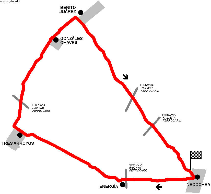
| Distinctive points | Necochea - Ruta 228 - Energía - Tres Arroyos - Ruta 3 - Gonzáles Chaves - Benito Juárez - Ruta 86 - Necochea | ||||
| length | 380.07 km | 236.171 mi | (1) | ||
| length | 369.048 km | 229.322 mi | Calculated from aerial photo (*) | (4) | |
| Average Speed (approx) | 215.46 km/h | 133.884 mph | Touring Car Argentinian Championship (TC) | (7) | |
Necochea 1960÷1967 (Map on Google Maps/Earth shows an approximated layout)
Due to technical problems, temporarily it’s no longer possible to see the circuits on Google Maps embedded in the current page.
This feature will be restored as soon as I figure out how to do (any help would be appreciated!)
See this track layout with Google Earth
- milermeter.com
(milermeter.com can be used in your browser, without installing anything; Google Earth is a program that must be installed in your computer)
(Map shown here above can show at the same time all eventual layouts drawn. If you want to see only some of them, please go to Google Maps or Google Earth, by clicking on its own link)
| Updates | |||||||
| Date | Track layout | Years | Description by | Map by | Thanks to | Note | |
| November 22nd 2009 | 1960÷1967 | Guido de Carli | Guido de Carli | Luis Alberto González | New | Description without map | |
| Not all eventual updates issued in last years are already visible in this list | |||||||


