| ARG - ARGENTINA | |||||||||||||||||||||||||||||
| ALTURAS DE PUNILLA | |||||||||||||||||||||||||||||
| Description | |||||||||||||||||||||||||||||
| Location | La Cumbre X - Córdoba - Centro | ||||||||||||||||||||||||||||
| Location | |||||||||||||||||||||||||||||
| Latitude - Longitude | - 30°57'04" - 64°29'55" -30.951111 -64.498611 | ||||||||||||||||||||||||||||
| UTM Coordinates | X = 356852.829 - Y = 6574853.227 - Zone 20J | ||||||||||||||||||||||||||||
| Aerial photo / Map (*) |  OpenStreetMap - Google Maps - Bing Maps - Flash Earth - Wikimapia OpenStreetMap - Google Maps - Bing Maps - Flash Earth - Wikimapia | ||||||||||||||||||||||||||||
| Altitude AMSL (approx) | 1150 m - 3773 ft (approx) | ||||||||||||||||||||||||||||
| Inauguration | May 30th 1965 | ||||||||||||||||||||||||||||
| Closing | March 28th 1971 | ||||||||||||||||||||||||||||
| Designer | |||||||||||||||||||||||||||||
| Sources and links (Translation) (**) |
| ||||||||||||||||||||||||||||
| Alturas de Punilla | |||||
| Description | |||||
| Years | 1965÷1971 | ||||
| Direction |  Anticlockwise Anticlockwise | ||||
 Proposal Proposal |
NO | ||||
| No longer operational | YES | ||||
| Car Circuit | YES | ||||
| Motorbike circuit | |||||
| Type | Road course | ||||
| Inauguration | May 30th 1965 | ||||
| Closing | March 28th 1971 | ||||
| Last update of this page | March 7th 2010 | ||||
| Info last update | |||||
| Designer | |||||
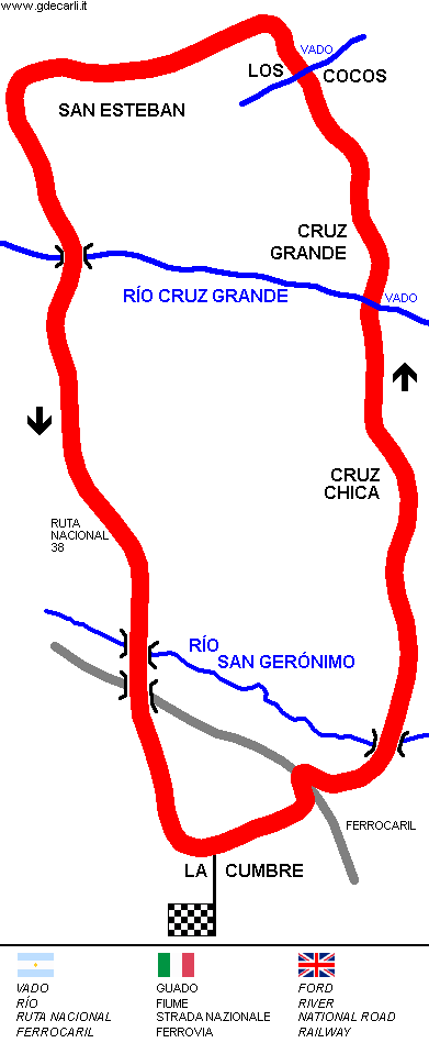
| Distinctive points | La Cumbre - Cruz Chica - Cruz Grande - Los Cocos - San Esteban | ||||
| length | 20400 m | 66929 ft | 12.676 mi | (2) | |
Alturas de Punilla
| Updates | |||||||
| Date | Track layout | Years | Description by | Map by | Thanks to | Note | |
| March 7th 2010 | 1965÷1971 | Guido de Carli | Guido de Carli | Luis Alberto González | New | Description with map | |
| Not all eventual updates issued in last years are already visible in this list | |||||||


