ARG - ARGENTINA
MERCEDES, 500 MILLAS MERCEDINAS
Not to be confused with Mercedes (1926÷1927) - Mercedes, SADAM
Description 
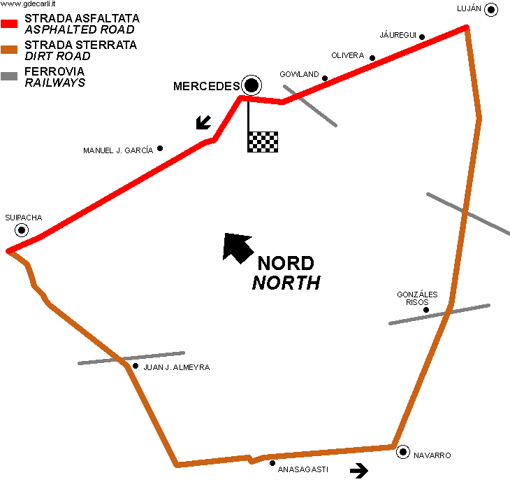
Traditional race for touring cars (Turismo Carrettera), held in 1952÷1958, 1960÷1966 and in 1975... Some different circuits were used.
Location Mercedes
B - Buenos Aires - Buenos Aires
Location  
Latitude - Longitude (approx) - 34°39'16"     - 59°25'43"     (approx)
-34.654444     -59.428611     (approx)
UTM Coordinates (approx) X = 277433.862  -  Y = 6162593.539  -  Zone 21H     (approx)
Aerial photo / Map (*) Aerial photo / Map (*) OpenStreetMap  -   Aerial photo / Map (*) Google Maps  -   Aerial photo / Map (*) Bing Maps  -   Aerial photo / Map (*) Flash Earth  -   Aerial photo / Map (*) Wikimapia
Altitude AMSL (approx) 40 m - 131 ft    (approx)
Inauguration 1952
Closing April 20th 1975
Designer  
Sources and links (Translation) (**)
(1) Angola Historia Deportiva del Automovilismo Argentino Author: Alfredo Parga - Published by: La Nación - Published in: Argentina - year: 1995
(2) Angola Manual, Guia, Enciclopedia, Cronica y Diccionario del Automovilismo Author: Alberto del Priore - Published by: Argentina Editorial IRCLA - Published in: Argentina - year: 1971
(3) Angola ForumForum --> Latin America --> Argentina --> Circuitos Argentinos [ESP] (with description and map)
(4) Angola www.actc.org.ar/modules/results/all.php?decada=60ACTC: list of all Turismo Carretera events (Argentinian Touring Car Championship)
(5) Angola www.actc.org.ar/modules/results/all.php?decada=70ACTC: list of all Turismo Carretera events (Argentinian Touring Car Championship)
(6) Angola Automundo 79/1966 [Publishing date: November 8th 1966]
(7) Angola Parabrisas Corsa 30/1966 [Publishing date: November 15th 1966]

(*) NOTE: a complete and detailed view of the circuit can be found (if available) on Street View by Google Maps and/or Bird's Eye and 3D views by Bing Maps for Enterprise (former Microsoft Virtual Earth): both can be reached using their own link in Aerial photo / Map cell.

(**) For on-line not-English speaking sources, click on each small flag and you open the corresponding Google Translator page with automatic translation.

500 millas Mercedinas / Vuelta de Mercedes
Description I don’t know how many track layouts were used in this period
Years 1952÷1958, 1960÷1963
Direction  
Progetto Proposal NO
No longer operational YES
Car Circuit YES
Motorbike circuit  
Type Road course
Inauguration  
Closing  
Last update of this page October 25th 2010
Info last update  
Designer  
Distinctive points  

500 millas Mercedinas / Vuelta de Mercedes
Description  
Years 1964÷1966
Direction Anticlockwise   Anticlockwise
Progetto Proposal NO
No longer operational YES
Car Circuit YES
Motorbike circuit  
Type Road course
Inauguration September 20th 1964
Closing November 20th 1966
Last update of this page October 25th 2010
Info last update  
Designer  
Distinctive points Mercedes (km 97,5 de la Ruta Nacional 5) - Manuel J. García - Suipacha - Juan J. Almeyra - Anasagasti - Navarro - Gonzáles Risos - Luján - Jáuregui - Gowland - Mercedes (km 97,5 de la Ruta Nacional 5)
length 62.06  km    38.563  mi asphalted sections only (3)
length 104.108  km    64.691  mi dirt sections only (3)
length 166.168  km    103.255  mi Total length (3)
length 48.048  km    29.856  mi Partial length from Mercedes (start line) to Juan J. Almeyra (3)
length 73.072  km    45.406  mi Partial length from Mercedes (start line) to Anasagasti (3)
length 83.082  km    51.626  mi Partial length from Mercedes (start line) to Navarro (3)
length 132.135  km    82.107  mi Partial length from Mercedes (start line) to Luján (3)
length 20027  m 65705  ft 12.445  mi Partial length from Mercedes (start line) to Suipacha (3)

500 millas Mercedinas / Vuelta de Mercedes
Description  
Years 1975
Direction  
Progetto Proposal NO
No longer operational YES
Car Circuit YES
Motorbike circuit  
Type Road course
Inauguration April 20th 1975
Closing April 20th 1975
Last update of this page October 25th 2010
Info last update  
Designer  
Distinctive points Chivilcoy - Chacabuco - Tres Sargentos - Carmen de Areco - Rawson
length 152.37  km    94.681  mi Total length (3)

500 millas Mercedinas / Vuelta de Mercedes (1964÷1966)

500 millas Mercedinas / Vuelta de Mercedes (1964÷1966)


Updates
Date Track layout Years Description by Map by Thanks to Note
October 25th 2010     Guido de Carli Guido de Carli Luis Alberto González New Description with map
Not all eventual updates issued in last years are already visible in this list
 
Webmaster:
Guido de Carli
(Italiano - English - Español)
Home Page HOME PAGE
DISCLAIMER (in Italian)