| ARG - ARGENTINA | |||||||||||||||||||||||||||||||||||||
| PAN DE AZÚCAR, MARIMÓN | |||||||||||||||||||||||||||||||||||||
| Not to be confused with | Desafio De Los Valientes - Villa Carlos Paz (callejero) - Villa Carlos Paz - San Francisco - Villa Carlos Paz - Villa Carlos Paz, Premio de la Montaña - Villa Carlos Paz, Santa Rita del Lago - Villa Carlos Paz, Vuelta de Lago | ||||||||||||||||||||||||||||||||||||
| Description | |||||||||||||||||||||||||||||||||||||
| Location | Villa Carlos Paz - Villa Allende - Villa Carlos Paz X - Córdoba - Centro | ||||||||||||||||||||||||||||||||||||
| Location | |||||||||||||||||||||||||||||||||||||
| Latitude - Longitude (approx) | - 31°19'00" - 64°22'00" (approx) -31.316667 -64.366667 (approx) | ||||||||||||||||||||||||||||||||||||
| UTM Coordinates (approx) | X = 369957.106 - Y = 6534496.319 - Zone 20J (approx) | ||||||||||||||||||||||||||||||||||||
| Aerial photo / Map (*) |  OpenStreetMap - Google Maps - Bing Maps - Flash Earth - Wikimapia OpenStreetMap - Google Maps - Bing Maps - Flash Earth - Wikimapia | ||||||||||||||||||||||||||||||||||||
| Altitude AMSL | |||||||||||||||||||||||||||||||||||||
| Inauguration | July 19th 1959 | ||||||||||||||||||||||||||||||||||||
| Closing | April 9th 1967 | ||||||||||||||||||||||||||||||||||||
| Designer | |||||||||||||||||||||||||||||||||||||
| Sources and links (Translation) (**) |
| ||||||||||||||||||||||||||||||||||||
| Circuito Pan de Azúcar / Circuito Onofre Marimón | |||||
| Description | |||||
| Years | 1959÷1962, 1964÷1965 | ||||
| Direction |  Anticlockwise Anticlockwise | ||||
 Proposal Proposal |
NO | ||||
| No longer operational | YES | ||||
| Car Circuit | YES | ||||
| Motorbike circuit | |||||
| Type | Road course | ||||
| Inauguration | July 19th 1959 | ||||
| Closing | 1965 | ||||
| Last update of this page | November 3rd 2010 | ||||
| Info last update | |||||
| Designer | |||||
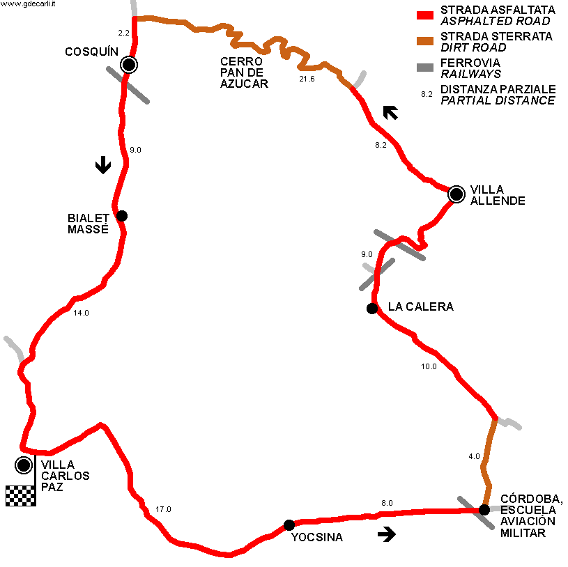
| Distinctive points | Villa Carlos Paz - Yocsina - Escuela de Aviación Militar (Córdoba) - La Calera - Villa Allende - Cerro Pan de Azucar - Cosquín - Bialet Massé - Villa Carlos Paz | ||||
| length | 103 km | 64.003 mi | (3) | ||
| length | 77 km | 47.847 mi | asphalted sections only | (3) | |
| length | 26000 m | 85302 ft | 16.156 mi | dirt sections only | (3) |
| Circuito Pan de Azúcar / Circuito Onofre Marimón | |||||
| Description | |||||
| Years | 1963 | ||||
| Direction |  Clockwise Clockwise | ||||
| Proposal |
NO | ||||
| No longer operational | YES | ||||
| Car Circuit | YES | ||||
| Motorbike circuit | |||||
| Type | Road course | ||||
| Inauguration | 1963 | ||||
| Closing | 1963 | ||||
| Last update of this page | November 3rd 2010 | ||||
| Info last update | |||||
| Designer | |||||
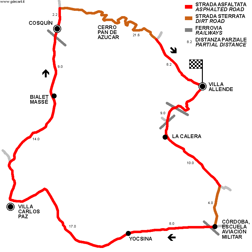
| Distinctive points | Villa Allende - La Calera - Escuela de Aviación Militar (Córdoba) - Yocsina - Villa Carlos Paz - Bialet Massé - Cosquín - Cerro Pan de Azucar - Villa Allende | ||||
| length | 103 km | 64.003 mi | (3) | ||
| length | 77 km | 47.847 mi | asphalted sections only | (3) | |
| length | 26000 m | 85302 ft | 16.156 mi | dirt sections only | (3) |
| Circuito Pan de Azúcar / Circuito Onofre Marimón | |||||
| Description | |||||
| Years | 1966÷1967 | ||||
| Direction | Anticlockwise | ||||
| Proposal |
NO | ||||
| No longer operational | YES | ||||
| Car Circuit | YES | ||||
| Motorbike circuit | |||||
| Type | Road course | ||||
| Inauguration | 1966 | ||||
| Closing | April 9th 1967 | ||||
| Last update of this page | November 3rd 2010 | ||||
| Info last update | |||||
| Designer | |||||
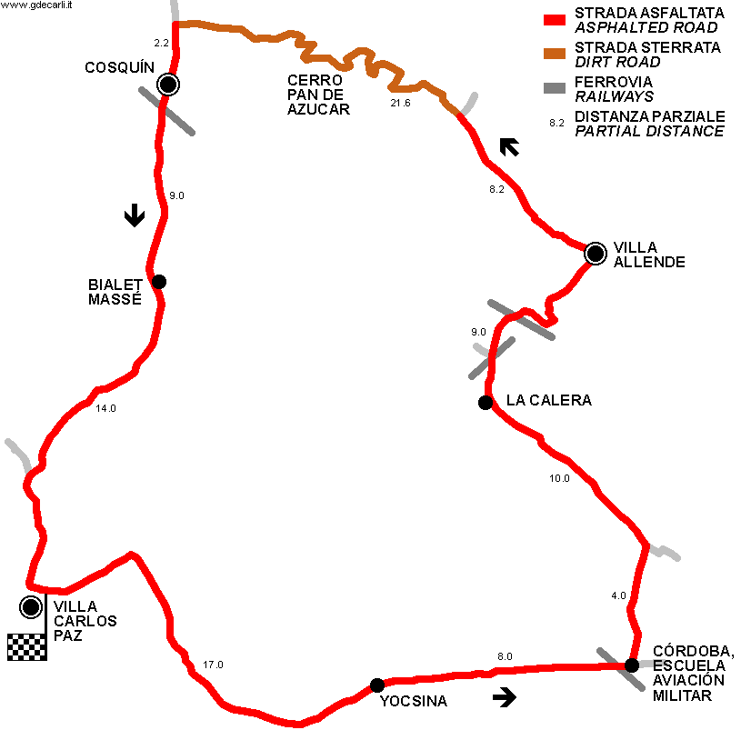
| Distinctive points | Villa Carlos Paz - Yocsina - Escuela de Aviación Militar (Córdoba) - La Calera - Villa Allende - Cerro Pan de Azucar - Cosquín - Bialet Massé - Villa Carlos Paz | ||||
| length | 103 km | 64.003 mi | (3) | ||
| length | 81.4 km | 50.581 mi | asphalted sections only | (3) | |
| length | 21600 m | 70866 ft | 13.422 mi | dirt sections only | (3) |
Circuito Pan de Azúcar / Circuito Onofre Marimón 1959÷1962, 1964÷1965
Circuito Pan de Azúcar / Circuito Onofre Marimón 1963
Circuito Pan de Azúcar / Circuito Onofre Marimón 1966÷1967
| PARTIAL DISTANCES | ||||||||||||||||||||||||||||||||||||||||||||||||||||||||||||||||||
(*) In 1963 it was raced in opposite direction | ||||||||||||||||||||||||||||||||||||||||||||||||||||||||||||||||||
| Updates | |||||||
| Date | Track layout | Years | Description by | Map by | Thanks to | Note | |
| November 3rd 2010 | Guido de Carli | Guido de Carli | Luis Alberto González | New | Description with map | ||
| Not all eventual updates issued in last years are already visible in this list | |||||||


