GEO - GEORGIA
BATUMI
Description 
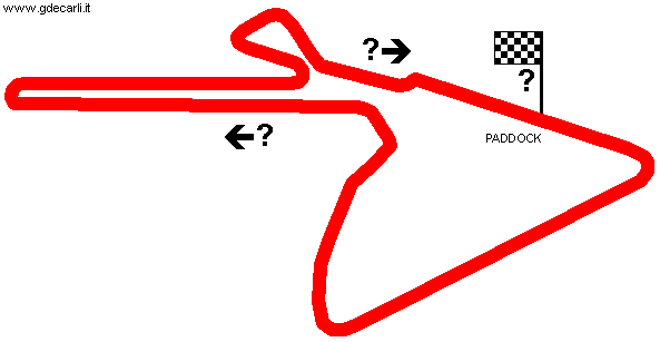
Street circuit used at least in 2010 and 2012
Location Batumi - Adjara
Location  
Latitude - Longitude + 41°38'01"     + 41°37'25"
41.633611     41.623611
UTM Coordinates X = 718532.264  -  Y = 4612423.076  -  Zone 37T
Aerial photo / Map (*) Aerial photo / Map (*) OpenStreetMap  -   Aerial photo / Map (*) Google Maps  -   Aerial photo / Map (*) Bing Maps  -   Aerial photo / Map (*) Flash Earth  -   Aerial photo / Map (*) Wikimapia
Altitude AMSL 5 m - 16 ft
Inauguration  
Closing  
Designer  
Sources and links (Translation) (**)
(1) English ForumForum --> Asia --> More countries --> GEO - Circuits in Georgia [ENG]
(2) English gasa.org.ge/en/sport/trails/racing/batumi.html

(*) NOTE: a complete and detailed view of the circuit can be found (if available) on Street View by Google Maps and/or Bird's Eye and 3D views by Bing Maps for Enterprise (former Microsoft Virtual Earth): both can be reached using their own link in Aerial photo / Map cell.

(**) For on-line not-English speaking sources, click on each small flag and you open the corresponding Google Translator page with automatic translation.

Batumi
Description Direction to be confirmed
Years  
Direction Clockwise   Clockwise
Progetto Proposal NO
No longer operational  
Car Circuit YES
Motorbike circuit  
Type Street course
Inauguration  
Closing  
Last update of this page January 24th 2012
Info last update  
Designer  
Distinctive points  

Batumi

Batumi


Updates
Date Track layout Years Description by Map by Thanks to Note
December 2nd 2012     Guido de Carli   Lutz Huppenbauer Update Description
January 24th 2012     Guido de Carli     New Description with map
Not all eventual updates issued in last years are already visible in this list
 
Webmaster:
Guido de Carli
(Italiano - English - Español)
Home Page HOME PAGE
DISCLAIMER (in Italian)