| ESP - SPAIN | |||||||||||||||||||||||||||||||||||||||||
| LAS PALMAS (LAS REHOYAS) | |||||||||||||||||||||||||||||||||||||||||
| Not to be confused with | Las Palmas (1983) - Las Palmas (Ciudad de Mar) | ||||||||||||||||||||||||||||||||||||||||
| Description | Street circuit that on May 8th 1966 hosted 2nd Circuito Automovilismo Ciudad de Las Palmas and that replaced Ciudad de Mar circuit used in 1965. On May 14th 1967 3rd Circuito Automovilismo Ciudad de Las Palmas was held, probably again on this circuit (but I don’t know anyting about track layout) | ||||||||||||||||||||||||||||||||||||||||
| Location | Las Palmas de Gran Canaria GC - Las Palmas - Canarias | ||||||||||||||||||||||||||||||||||||||||
| Location | Polígono Industrial de Betancores - Las Rehoyas, Las Palmas de Gran Canaria | ||||||||||||||||||||||||||||||||||||||||
| Latitude - Longitude (approx) | + 28°06'29" - 15°25'47" (approx) 28.108056 -15.429722 (approx) | ||||||||||||||||||||||||||||||||||||||||
| UTM Coordinates (approx) | X = 457790.649 - Y = 3109246.957 - Zone 28R (approx) | ||||||||||||||||||||||||||||||||||||||||
| Aerial photo / Map (*) |  OpenStreetMap - Google Maps - Bing Maps - Flash Earth - Wikimapia - Visor SIGPAC OpenStreetMap - Google Maps - Bing Maps - Flash Earth - Wikimapia - Visor SIGPAC | ||||||||||||||||||||||||||||||||||||||||
| Altitude AMSL (approx) | 80 m - 262 ft (approx) | ||||||||||||||||||||||||||||||||||||||||
| Inauguration | May 8th 1966 | ||||||||||||||||||||||||||||||||||||||||
| Closing | |||||||||||||||||||||||||||||||||||||||||
| Designer | |||||||||||||||||||||||||||||||||||||||||
| Sources and links (Translation) (**) |
| ||||||||||||||||||||||||||||||||||||||||
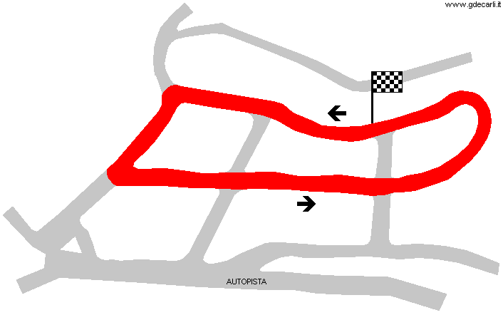
| Circuito Ciudad de Las Palmas - Las Rehoyas | |||||
| Description | |||||
| Years | 1966÷? | ||||
| Direction |  Anticlockwise Anticlockwise | ||||
 Proposal Proposal |
NO | ||||
| No longer operational | YES | ||||
| Car Circuit | YES | ||||
| Motorbike circuit | |||||
| Type | Street course | ||||
| Inauguration | May 8th 1966 | ||||
| Closing | |||||
| Last update of this page | October 21st 2019 | ||||
| Info last update | |||||
| Designer | |||||
| Distinctive points | |||||
| length | 1850 m | 6070 ft | 1.15 mi | (4) | |
Las Palmas (Las Rehoyas)
| Updates | |||||||
| Date | Track layout | Years | Description by | Map by | Thanks to | Note | |
| October 21st 2019 | Circuito Ciudad de Las Palmas - Las Rehoyas | 1966÷? | Guido de Carli | Guido de Carli | New | Description with map | |
| Not all eventual updates issued in last years are already visible in this list | |||||||


