| ARG - ARGENTINA | |||||
| VIEDMA | |||||
| Description | |||||
| Location | Viedma R - Río Negro - Patagonia | ||||
| Location | |||||
| Latitude - Longitude | - 40°51'22" - 63°01'06" -40.856111 -63.018333 | ||||
| UTM Coordinates | X = 498454.818 - Y = 5477215.62 - Zone 20G | ||||
| Aerial photo / Map (*) |  OpenStreetMap - Google Maps - Bing Maps - Flash Earth - Wikimapia OpenStreetMap - Google Maps - Bing Maps - Flash Earth - Wikimapia | ||||
| Altitude AMSL | 5 m - 16 ft | ||||
| Inauguration | |||||
| Closing | |||||
| Designer | |||||
| Sources and links (Translation) (**) |
| ||||
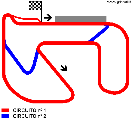
| Circuito nº 1 | |||||
| Description | |||||
| Years | |||||
| Direction |  Clockwise Clockwise | ||||
 Proposal Proposal |
NO | ||||
| No longer operational | |||||
| Car Circuit | |||||
| Motorbike circuit | |||||
| Type | Permanent | ||||
| Inauguration | |||||
| Closing | |||||
| Last update of this page | June 19th 2007 | ||||
| Info last update | |||||
| Designer | |||||
| Distinctive points | |||||
| length | 4118.8 m | 13513 ft | 2.559 mi | ||
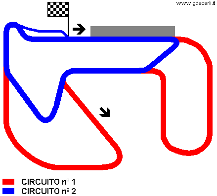
| Circuito nº 2 | |||||
| Description | |||||
| Years | |||||
| Direction | Clockwise | ||||
| Proposal |
NO | ||||
| No longer operational | |||||
| Car Circuit | |||||
| Motorbike circuit | |||||
| Type | Permanent | ||||
| Inauguration | |||||
| Closing | |||||
| Last update of this page | June 19th 2007 | ||||
| Info last update | |||||
| Designer | |||||
| Distinctive points | |||||
| length | 1100 m | 3609 ft | 0.684 mi | ||
Viedma, Circuito nº 1
Viedma, Circuito nº 2
| Updates | |||||||
| Date | Track layout | Years | Description by | Map by | Thanks to | Note | |
| December 28th 2004 | Guido de Carli | New | Description with map | ||||
| Not all eventual updates issued in last years are already visible in this list | |||||||


