| SWE - SWEDEN | |||||
| NORRKÖPING | |||||
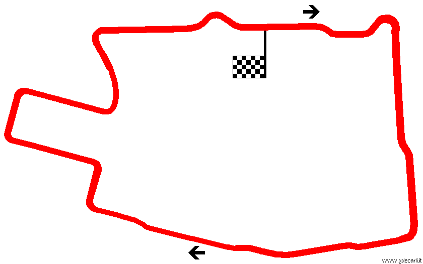
| Description | Street circuit used from 1986 to 1988. Map from Autosprint was published in March 1986; track inauguration should have been on May 9th-11th 1986. | ||||
| Location | Norrköping E - Östergötland - Östra Mellansverige | ||||
| Location | |||||
| Latitude - Longitude | + 58°35'33" + 16°12'38" 58.5925 16.210556 | ||||
| UTM Coordinates | X = 570366.825 - Y = 6495312.586 - Zone 33V | ||||
| Aerial photo / Map (*) |  OpenStreetMap - Google Maps - Bing Maps - Flash Earth - Wikimapia - Eniro OpenStreetMap - Google Maps - Bing Maps - Flash Earth - Wikimapia - Eniro | ||||
| Altitude AMSL | 15 m - 49 ft | ||||
| Inauguration | |||||
| Closing | |||||
| Designer | |||||
| Sources and links (Translation) (**) |
| ||||
| Norrköping | |||||
| Description | |||||
| Years | |||||
| Direction |  Clockwise Clockwise | ||||
 Proposal Proposal |
NO | ||||
| No longer operational | YES | ||||
| Car Circuit | YES | ||||
| Motorbike circuit | |||||
| Type | Street course | ||||
| Inauguration | |||||
| Closing | |||||
| Last update of this page | October 15th 2003 | ||||
| Info last update | March 1986 | ||||
| Designer | |||||
| Distinctive points | |||||
| length | 3370 m | 11056 ft | 2.094 mi | (1) | |
| Straight length | 250 m | 820 ft | 0.155 mi | Longest straight | (1) |
Norrköping
| Updates | |||||||
| Date | Track layout | Years | Description by | Map by | Thanks to | Note | |
| October 15th 2003 | Guido de Carli | Update | Description | ||||
| August 14th 2002 | Guido de Carli | New | Map | ||||
| Not all eventual updates issued in last years are already visible in this list | |||||||


