| TUN - TUNISIA | |||||||||||||||||||||||||||||
| CARTHAGE | |||||||||||||||||||||||||||||
| SORRY, SOME DATA ARE NOT TRANSLATED YET | |||||||||||||||||||||||||||||
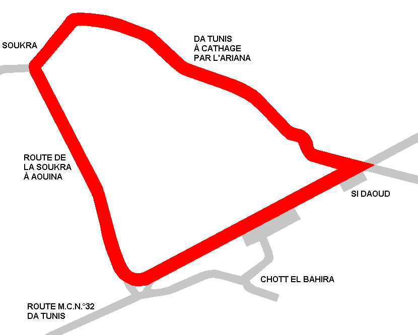
| Description | Circuit used for Tunisian GP in 1931-1933 and 1935-1937. Drivers appreciated it very much but two chicanes (the one on main straight was removed for 1935 edition only) Comparing photos on Ruoteclassiche to map on racingcircuits.net, I think that direction was clockwise | ||||||||||||||||||||||||||||
| Location | Carthage, Tunis / Cartagine, Tunisi - Tunis | ||||||||||||||||||||||||||||
| Location | North East from Tunis, near Charthage and not far from the sea | ||||||||||||||||||||||||||||
| Latitude - Longitude | + 36°52'01" + 10°16'00" 36.866944 10.266667 | ||||||||||||||||||||||||||||
| UTM Coordinates | X = 612901.725 - Y = 4080861.013 - Zone 32S | ||||||||||||||||||||||||||||
| Aerial photo / Map (*) |  OpenStreetMap - Google Maps - Bing Maps - Flash Earth - Wikimapia OpenStreetMap - Google Maps - Bing Maps - Flash Earth - Wikimapia | ||||||||||||||||||||||||||||
| Altitude AMSL | 5 m - 16 ft | ||||||||||||||||||||||||||||
| Inauguration | March 29th 1931 | ||||||||||||||||||||||||||||
| Closing | May 16th 1937 | ||||||||||||||||||||||||||||
| Designer | |||||||||||||||||||||||||||||
| Sources and links (Translation) (**) |
| ||||||||||||||||||||||||||||
| Carthage (1931-1933 ÷ 1936-1937) | |||||
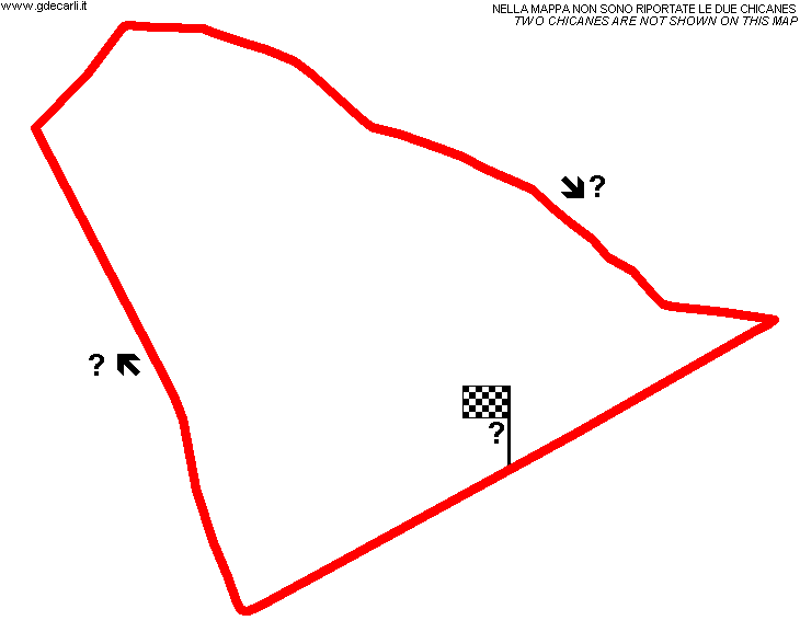
| Description | Two chicanes are not shown on my map | ||||
| Years | 1931÷1933 ÷ 1936÷1937 | ||||
| Direction |  Clockwise Clockwise | ||||
 Proposal Proposal |
NO | ||||
| No longer operational | YES | ||||
| Car Circuit | YES | ||||
| Motorbike circuit | |||||
| Type | Road course | ||||
| Inauguration | March 26th 1931 | ||||
| Closing | May 16th 1937 | ||||
| Last update of this page | |||||
| Info last update | |||||
| Designer | |||||
| Distinctive points | |||||
| length | 12700 m | 41667 ft | 7.892 mi | (5) | |
| length | 12700 m | 41667 ft | 7.892 mi | (6) | |
| length | 12714 m | 41713 ft | 7.9 mi | (3) | |
| Carthage (1935) | |||||
| Description | In comparison to usual track layout, chicane on main straight was removed. The other one was still in use, but it is not shown on my map | ||||
| Years | 1935 | ||||
| Direction | Clockwise | ||||
| Proposal |
NO | ||||
| No longer operational | YES | ||||
| Car Circuit | YES | ||||
| Motorbike circuit | |||||
| Type | Road course | ||||
| Inauguration | May 5th 1935 | ||||
| Closing | May 5th 1935 | ||||
| Last update of this page | May 23rd 2003 | ||||
| Info last update | |||||
| Designer | |||||
| Distinctive points | |||||
| length | 12600 m | 41339 ft | 7.829 mi | (4) | |
Carthage
Due to technical problems, temporarily it’s no longer possible to see the circuits on Google Maps embedded in the current page.
This feature will be restored as soon as I figure out how to do (any help would be appreciated!)
See this track layout with Google Earth
(milermeter.com can be used in your browser, without installing anything; Google Earth is a program that must be installed in your computer)
(Map shown here above can show at the same time all eventual layouts drawn. If you want to see only some of them, please go to Google Maps or Google Earth, by clicking on its own link)
| Updates | |||||||
| Date | Track layout | Years | Description by | Map by | Thanks to | Note | |
| November 24th 2007 | Lorenzo Tommasi | Guido de Carli | Update | Map | |||
| April 8th 2006 | Guido de Carli | Lorenzo Tommasi | New | Description | |||
| August 7th 2003 | Guido de Carli | Guido de Carli | New | Description with map | |||
| Not all eventual updates issued in last years are already visible in this list | |||||||


