| USA - UNITED STATES | |||||
| SAN ANTONIO | |||||
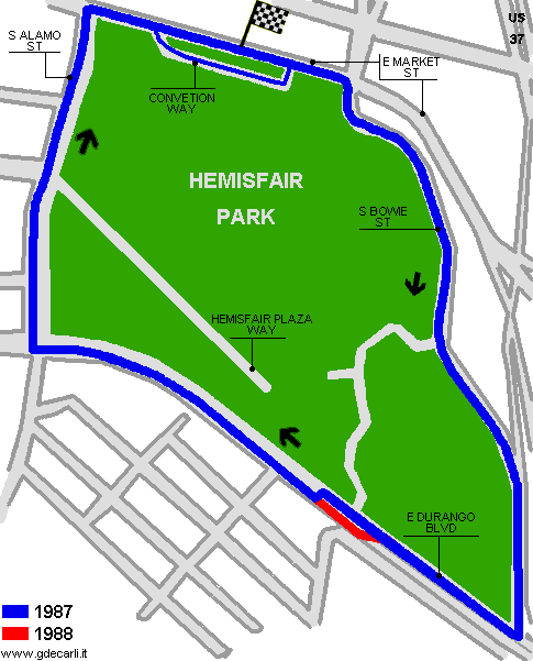
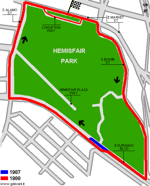
| Description | Street circuit used by IMSA. It was on Hemisfair Park perimeter roads. First used in 1987, in 1988 it was slightly modified (a chicane was removed) ad it was used until 1990. | ||||
| Location | San Antonio TX - Texas - Southern States | ||||
| Location | |||||
| Latitude - Longitude | + 29°25'21" - 98°29'08" 29.4225 -98.485556 | ||||
| UTM Coordinates | X = 549902.04 - Y = 3254906.527 - Zone 14R | ||||
| Aerial photo / Map (*) |  OpenStreetMap - Google Maps - Bing Maps - Flash Earth - Wikimapia - Microsoft Research Maps - MapQuest OpenStreetMap - Google Maps - Bing Maps - Flash Earth - Wikimapia - Microsoft Research Maps - MapQuest | ||||
| Altitude AMSL | 197 m - 646 ft | ||||
| Inauguration | 1987 | ||||
| Closing | 1990 | ||||
| Designer | |||||
| Sources and links (Translation) (**) |
| ||||
| San Antonio | |||||
| Description | |||||
| Years | 1987 | ||||
| Direction |  Clockwise Clockwise | ||||
 Proposal Proposal |
NO | ||||
| No longer operational | YES | ||||
| Car Circuit | YES | ||||
| Motorbike circuit | |||||
| Type | Street course | ||||
| Inauguration | 1987 | ||||
| Closing | 1987 | ||||
| Last update of this page | December 21st 2005 | ||||
| Info last update | |||||
| Designer | |||||
| Distinctive points | E Market Street - S Bowie Street - E Durango Boulevard - S Alamo Street - Convention Street | ||||
| length | 2716 m | 8912 ft | 1.688 mi | ||
| San Antonio | |||||
| Description | |||||
| Years | 1988÷1990 | ||||
| Direction | Clockwise | ||||
| Proposal |
NO | ||||
| No longer operational | YES | ||||
| Car Circuit | YES | ||||
| Motorbike circuit | |||||
| Type | Street course | ||||
| Inauguration | 1988 | ||||
| Closing | 1990 | ||||
| Last update of this page | December 21st 2005 | ||||
| Info last update | |||||
| Designer | |||||
| Distinctive points | E Market Street - S Bowie Street - E Durango Boulevard - S Alamo Street - Convention Street | ||||
| length | 2688 m | 8817 ft | 1.67 mi | ||
San Antonio 1987
San Antonio 1988÷1990
| Updates | |||||||
| Date | Track layout | Years | Description by | Map by | Thanks to | Note | |
| December 22nd 2005 | Lorenzo Tommasi | Lorenzo Tommasi | New | Description with map | |||
| November 12th 2005 | Guido de Carli | Guido de Carli | Lorenzo Tommasi | New | Description with map | ||
| Not all eventual updates issued in last years are already visible in this list | |||||||


