| ZIM - ZIMBABWE | |||||||||||||||||
| BELVEDERE STREET | |||||||||||||||||
| Description | Street circuit. I have no more info. Not to be confused with Belvedere airfield circuit, few meters far. | ||||||||||||||||
| Location | Salisbury / Harare - Harare | ||||||||||||||||
| Location | Close to former Belvedere airfield, North West of Salisbury (renamed Harare on April 18th 1982). Before April 18th 1980, Zimbabwe was named Southern Rhodesia. | ||||||||||||||||
| Latitude - Longitude | - 17°49'51" + 31°02'08" -17.830833 31.035556 | ||||||||||||||||
| UTM Coordinates | X = 291808.051 - Y = 8027437.104 - Zone 36K | ||||||||||||||||
| Aerial photo / Map (*) |  OpenStreetMap - Google Maps - Bing Maps - Flash Earth - Wikimapia OpenStreetMap - Google Maps - Bing Maps - Flash Earth - Wikimapia | ||||||||||||||||
| Altitude AMSL | 1485 m - 4872 ft | ||||||||||||||||
| Inauguration | |||||||||||||||||
| Closing | |||||||||||||||||
| Designer | |||||||||||||||||
| Sources and links (Translation) (**) |
| ||||||||||||||||
| Belvedere Street | |||||
| Description | |||||
| Years | |||||
| Direction |  Clockwise Clockwise | ||||
 Proposal Proposal |
NO | ||||
| No longer operational | YES | ||||
| Car Circuit | YES | ||||
| Motorbike circuit | YES | ||||
| Type | Street course | ||||
| Inauguration | |||||
| Closing | |||||
| Last update of this page | February 23rd 2009 | ||||
| Info last update | |||||
| Designer | |||||
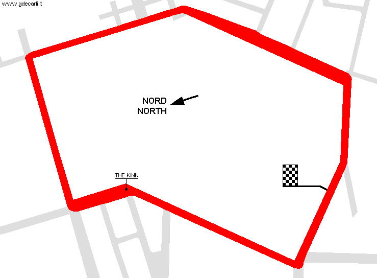
| Distinctive points | Rekayi Tangwena Avenue (McDonald Avenue) - The Kink - Drummond Chaplin Street - Herbert Chitepo Avenue (Rhodes Avenue) - Prince Edward Street - Rotten Row - Belvedere Road | ||||
| length | 3219 m | 10560 ft | 2 mi | (1) | |
| length | 4077 m | 13378 ft | 2.534 mi | Calculated from aerial photo (*) | (4) |
Belvedere Street
Due to technical problems, temporarily it’s no longer possible to see the circuits on Google Maps embedded in the current page.
This feature will be restored as soon as I figure out how to do (any help would be appreciated!)
See this track layout with Google Earth
- milermeter.com
(milermeter.com can be used in your browser, without installing anything; Google Earth is a program that must be installed in your computer)
(Map shown here above can show at the same time all eventual layouts drawn. If you want to see only some of them, please go to Google Maps or Google Earth, by clicking on its own link)
| Updates | |||||||
| Date | Track layout | Years | Description by | Map by | Thanks to | Note | |
| February 23rd 2009 | Guido de Carli | Roelard Smit | Roelard Smit | Update | Description with map | ||
| March 29th 2006 | Guido de Carli | Guido de Carli | Marius Matthee | New | Description with map | ||
| Not all eventual updates issued in last years are already visible in this list | |||||||


