| CUR - CURAÇAO | |||||||||||||||||||||||||||||||||
| WILLEMSTADT | |||||||||||||||||||||||||||||||||
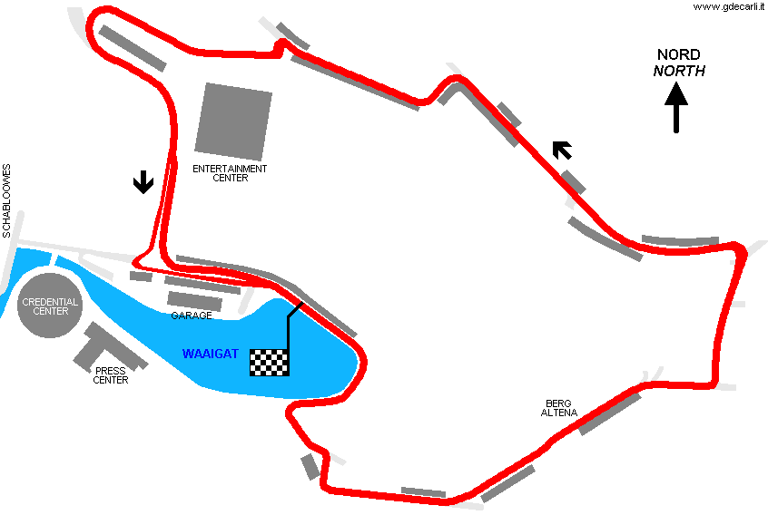
| Description | Street circuit, used only for a F.3000 non championship race on October 13th 1985, organized by SCCA and won by John Nielsen (Ralt). The race was a test for hosting in 1986 a F.1 GP. Both circuit and organization were inadequate even for F.3000, so hopes for F.1 vanished. In 1986 a race valid for F.3000 Intercontinental Championship was scheduled, but it was canceled. | ||||||||||||||||||||||||||||||||
| Location | Willemstadt | ||||||||||||||||||||||||||||||||
| Location | Near to Waaigat, Willemstadt, capital of Curaçao | ||||||||||||||||||||||||||||||||
| Latitude - Longitude | + 12°06'21" - 68°55'36" 12.105833 -68.926667 | ||||||||||||||||||||||||||||||||
| UTM Coordinates | X = 507979.838 - Y = 1338257.557 - Zone 19P | ||||||||||||||||||||||||||||||||
| Aerial photo / Map (*) |  OpenStreetMap - Google Maps - Bing Maps - Flash Earth - Wikimapia OpenStreetMap - Google Maps - Bing Maps - Flash Earth - Wikimapia | ||||||||||||||||||||||||||||||||
| Altitude AMSL | 1 m - 3 ft | ||||||||||||||||||||||||||||||||
| Inauguration | October 13th 1985 | ||||||||||||||||||||||||||||||||
| Closing | October 13th 1985 | ||||||||||||||||||||||||||||||||
| Designer | |||||||||||||||||||||||||||||||||
| Sources and links (Translation) (**) |
| ||||||||||||||||||||||||||||||||
| Willemstadt | |||||
| Description | |||||
| Years | 1985 | ||||
| Direction |  Anticlockwise Anticlockwise | ||||
 Proposal Proposal |
NO | ||||
| No longer operational | YES | ||||
| Car Circuit | YES | ||||
| Motorbike circuit | |||||
| Type | Street course | ||||
| Inauguration | October 13th 1985 | ||||
| Closing | October 13th 1985 | ||||
| Last update of this page | January 8th 2009 | ||||
| Info last update | |||||
| Designer | |||||
| Distinctive points | |||||
| length | 3550 m | 11647 ft | 2.206 mi | (6) | |
| length | 3538 m | 11607 ft | 2.198 mi | Calculated from aerial photo (*) | (4) |
Willemstadt
Due to technical problems, temporarily it’s no longer possible to see the circuits on Google Maps embedded in the current page.
This feature will be restored as soon as I figure out how to do (any help would be appreciated!)
See this track layout with Google Earth
- milermeter.com
(milermeter.com can be used in your browser, without installing anything; Google Earth is a program that must be installed in your computer)
(Map shown here above can show at the same time all eventual layouts drawn. If you want to see only some of them, please go to Google Maps or Google Earth, by clicking on its own link)
| Updates | |||||||
| Date | Track layout | Years | Description by | Map by | Thanks to | Note | |
| January 8th 2009 | 1985 | Guido de Carli | Guido de Carli | Lorenzo Tommasi | Update | Description with map | |
| September 10th 2005 | 1985 | Guido de Carli | Guido de Carli | New | Description with map | ||
| Not all eventual updates issued in last years are already visible in this list | |||||||


