| ARG - ARGENTINA | |||||||||||||||||||||||||||||||||||||||||||||||||
| BALCARCE, FANGIO | |||||||||||||||||||||||||||||||||||||||||||||||||
| SORRY, SOME DATA ARE NOT TRANSLATED YET | |||||||||||||||||||||||||||||||||||||||||||||||||
| Description | |||||||||||||||||||||||||||||||||||||||||||||||||
| Location | San José de Balcarce B - Buenos Aires - Buenos Aires | ||||||||||||||||||||||||||||||||||||||||||||||||
| Location | |||||||||||||||||||||||||||||||||||||||||||||||||
| Latitude - Longitude | - 37°52'53" - 58°16'21" -37.881389 -58.2725 | ||||||||||||||||||||||||||||||||||||||||||||||||
| UTM Coordinates | X = 388095.91 - Y = 5806581.886 - Zone 21H | ||||||||||||||||||||||||||||||||||||||||||||||||
| Aerial photo / Map (*) |  OpenStreetMap - Google Maps - Bing Maps - Flash Earth - Wikimapia OpenStreetMap - Google Maps - Bing Maps - Flash Earth - Wikimapia | ||||||||||||||||||||||||||||||||||||||||||||||||
| Altitude AMSL | 140 m - 459 ft | ||||||||||||||||||||||||||||||||||||||||||||||||
| Inauguration | January 18th 1971 | ||||||||||||||||||||||||||||||||||||||||||||||||
| Closing | |||||||||||||||||||||||||||||||||||||||||||||||||
| Designer | |||||||||||||||||||||||||||||||||||||||||||||||||
| Sources and links (Translation) (**) |
| ||||||||||||||||||||||||||||||||||||||||||||||||
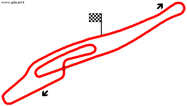
| Autódromo Juan Manuel Fangio | |||||
| Description | |||||
| Years | 1971÷... | ||||
| Direction |  Clockwise Clockwise | ||||
 Proposal Proposal |
NO | ||||
| No longer operational | |||||
| Car Circuit | YES | ||||
| Motorbike circuit | |||||
| Type | Permanent | ||||
| Inauguration | January 18th 1971 | ||||
| Closing | |||||
| Last update of this page | June 18th 2006 | ||||
| Info last update | |||||
| Designer | |||||
| Distinctive points | |||||
| length | 4592 m | 15066 ft | 2.853 mi | (2) | |
| length | 4592.4 m | 15067 ft | 2.854 mi | (3) | |
| length | 4592.4 m | 15067 ft | 2.854 mi | (6) | |
| length | 4592.5 m | 15067 ft | 2.854 mi | (12) | |
| Autódromo Juan Manuel Fangio | |||||
| Description | Circuit still under construction ,but nearly ready | ||||
| Years | 1970 | ||||
| Direction | Clockwise | ||||
| Proposal |
YES
| ||||
| Proposal not developed | |||||
| Car Circuit | YES | ||||
| Motorbike circuit | |||||
| Type | Permanent | ||||
| Inauguration | |||||
| Closing | |||||
| Last update of this page | June 18th 2006 | ||||
| Info last update | |||||
| Designer | |||||
| Distinctive points | |||||
| length | 4522.3 m | 14837 ft | 2.81 mi | (10) | |
| Autódromo Juan Manuel Fangio | |||||
| Description | Long track, to be built after Autódromo Fangio will be opened, so not before 1971 | ||||
| Years | |||||
| Direction | |||||
| Proposal |
YES
| ||||
| Proposal not developed | YES | ||||
| Car Circuit | YES | ||||
| Motorbike circuit | |||||
| Type | |||||
| Inauguration | |||||
| Closing | |||||
| Last update of this page | April 13th 2006 | ||||
| Info last update | December 1st 1969 | ||||
| Designer | |||||
| Distinctive points | |||||
| length | 25000 m | 82021 ft | 15.535 mi | (8) | |
Balcarce, Fangio
| Updates | |||||||
| Date | Track layout | Years | Description by | Map by | Thanks to | Note | |
| November 5th 2007 | Guido de Carli | Update | Description without map | ||||
| December 28th 2004 | Guido de Carli | Guido de Carli | New | Description with map | |||
| September 15th 2004 | Guido de Carli | New | Description | ||||
| Not all eventual updates issued in last years are already visible in this list | |||||||


