| ITA - ITALY | |||||||||||||||||
| GORIZIA | |||||||||||||||||
| Description | |||||||||||||||||
| Location | Gorizia GO - Gorizia - Friuli-Venezia Giulia | ||||||||||||||||
| Location | |||||||||||||||||
| Latitude - Longitude | + 45°56'10" + 13°36'26" 45.936111 13.607222 | ||||||||||||||||
| UTM Coordinates | X = 392030.251 - Y = 5087892.087 - Zone 33T | ||||||||||||||||
| Aerial photo / Map (*) |  OpenStreetMap - Google Maps - Bing Maps - Flash Earth - Wikimapia OpenStreetMap - Google Maps - Bing Maps - Flash Earth - Wikimapia | ||||||||||||||||
| Altitude AMSL | 74 m - 243 ft | ||||||||||||||||
| Inauguration | September 18th 1949 | ||||||||||||||||
| Closing | |||||||||||||||||
| Designer | |||||||||||||||||
| Sources and links (Translation) (**) |
| ||||||||||||||||
| Circuito di Velocità Città di Gorizia | |||||
| Description | |||||
| Years | 1949 | ||||
| Direction |  Anticlockwise Anticlockwise | ||||
 Proposal Proposal |
NO | ||||
| No longer operational | YES | ||||
| Car Circuit | |||||
| Motorbike circuit | YES | ||||
| Type | Street course | ||||
| Inauguration | September 18th 1949 | ||||
| Closing | September 18th 1949 | ||||
| Last update of this page | January 14th 2013 | ||||
| Info last update | |||||
| Designer | |||||
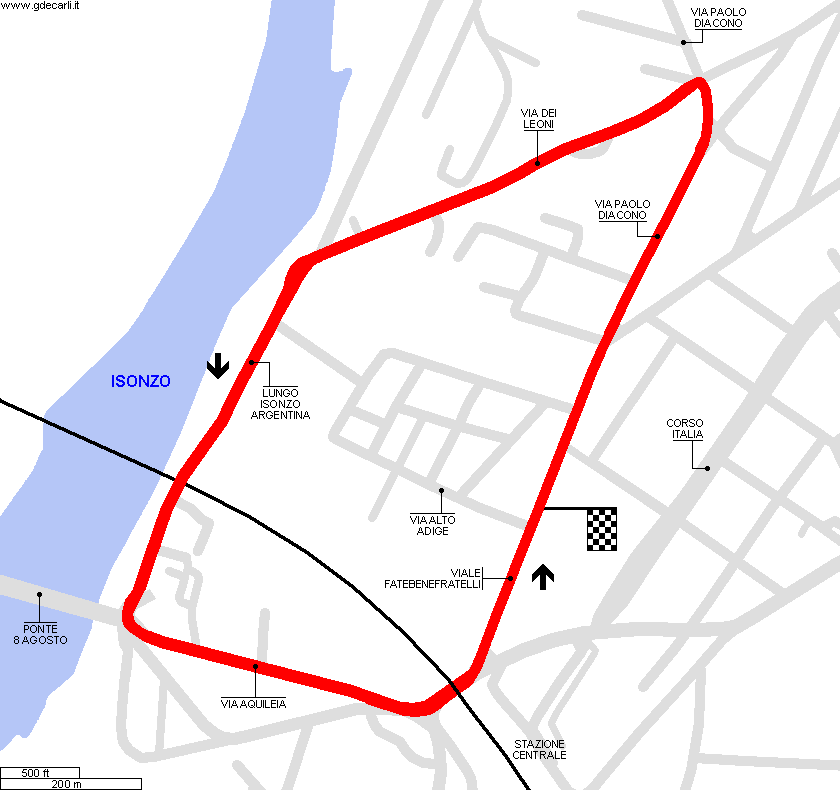
| Distinctive points | via Fatebenefratelli - via Paolo Diacono - via dei Leoni - Lungo Isonzo Argentina - via Aquileia - sottopasso Ferroviario | ||||
| length | 3000 m | 9843 ft | 1.864 mi | (3) | |
| length | 2550 m | 8365 ft | 1.584 mi | Calculated from aerial photo (*) | (1) |
| Circuito Automobilistico di Santa Gorizia | |||||
| Description | |||||
| Years | 1950, 1954÷1955 | ||||
| Direction | Anticlockwise | ||||
| Proposal |
NO | ||||
| No longer operational | YES | ||||
| Car Circuit | YES | ||||
| Motorbike circuit | |||||
| Type | Road course | ||||
| Inauguration | |||||
| Closing | |||||
| Last update of this page | January 14th 2013 | ||||
| Info last update | |||||
| Designer | |||||
| Distinctive points | Corso Italia - Via Armando Diaz - Via Giacomo Leopardi - Via dei Leoni - Lungo Isonzo Argentina - Via Aquileia - Corso Italia | ||||
| length | 4040 m | 13255 ft | 2.51 mi | (4) | |
| length | 4055 m | 13305 ft | 2.52 mi | Calculated from aerial photo (*) | (2) |
Gorizia: comparison between layouts
Due to technical problems, temporarily it’s no longer possible to see the circuits on Google Maps embedded in the current page.
This feature will be restored as soon as I figure out how to do (any help would be appreciated!)
See this track layout with Google Earth
(milermeter.com can be used in your browser, without installing anything; Google Earth is a program that must be installed in your computer)
(Map shown here above can show at the same time all eventual layouts drawn. If you want to see only some of them, please go to Google Maps or Google Earth, by clicking on its own link)
Circuito di Velocità Città di Gorizia 1949
Due to technical problems, temporarily it’s no longer possible to see the circuits on Google Maps embedded in the current page.
This feature will be restored as soon as I figure out how to do (any help would be appreciated!)
See this track layout with Google Earth
- milermeter.com
(milermeter.com can be used in your browser, without installing anything; Google Earth is a program that must be installed in your computer)
(Map shown here above can show at the same time all eventual layouts drawn. If you want to see only some of them, please go to Google Maps or Google Earth, by clicking on its own link)
Circuito di Velocità Città di Gorizia 195x
Due to technical problems, temporarily it’s no longer possible to see the circuits on Google Maps embedded in the current page.
This feature will be restored as soon as I figure out how to do (any help would be appreciated!)
See this track layout with Google Earth
- milermeter.com
(milermeter.com can be used in your browser, without installing anything; Google Earth is a program that must be installed in your computer)
(Map shown here above can show at the same time all eventual layouts drawn. If you want to see only some of them, please go to Google Maps or Google Earth, by clicking on its own link)
| Updates | |||||||
| Date | Track layout | Years | Description by | Map by | Thanks to | Note | |
| January 15th 2013 | Guido de Carli | Guido de Carli | Nanni Dietrich | Update | Description with map | ||
| February 24th 2007 | Circuito di Velocità Città di Gorizia | 1949 | Guido de Carli | Guido de Carli | Pier Paolo Garagnani | New | Description with map |
| Not all eventual updates issued in last years are already visible in this list | |||||||


