| ITA - ITALY | |||||||||||||||||
| ASCOLI PICENO, CALDAIE | |||||||||||||||||
| Not to be confused with | Ascoli Piceno - Ascoli Piceno - Piagge - San Marco - San Giacomo (Teodori) - Ascoli Piceno, Borgo Solestà - Ascoli Piceno, Zappelle | ||||||||||||||||
| Description | Street circuit, used from 1932 to 1938, from June 24th 1951 to 1960 and for historical parade from 2010. I have no more info. My map shown streets as they are today; possibly in 1950s they were slightly different. | ||||||||||||||||
| Location | Ascoli Piceno AP - Ascoli Piceno - Marche | ||||||||||||||||
| Location | |||||||||||||||||
| Latitude - Longitude | + 42°51'09" + 13°35'40" 42.8525 13.594444 | ||||||||||||||||
| UTM Coordinates | X = 385160.906 - Y = 4745393.487 - Zone 33T | ||||||||||||||||
| Aerial photo / Map (*) |  OpenStreetMap - Google Maps - Bing Maps - Flash Earth - Wikimapia OpenStreetMap - Google Maps - Bing Maps - Flash Earth - Wikimapia | ||||||||||||||||
| Altitude AMSL | 140 m - 459 ft | ||||||||||||||||
| Inauguration | |||||||||||||||||
| Closing | |||||||||||||||||
| Designer | |||||||||||||||||
| Sources and links (Translation) (**) |
| ||||||||||||||||
| Circuito delle Caldaie | |||||
| Description | I don’t know if 1930s layout is the same used from June 24nd 1951 to 1960 or if it was different | ||||
| Years | 1932?÷1938?, 1951÷1960, 2010 | ||||
| Direction | |||||
 Proposal Proposal |
NO | ||||
| No longer operational | YES | ||||
| Car Circuit | |||||
| Motorbike circuit | |||||
| Type | Street course | ||||
| Inauguration | |||||
| Closing | 2010 | ||||
| Last update of this page | July 8th 2011 | ||||
| Info last update | |||||
| Designer | |||||
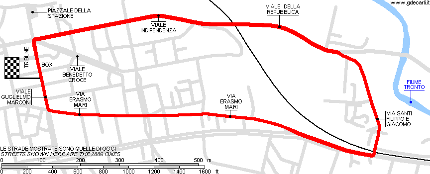
| Distinctive points | Viale Indipendenza - Viale della Repubblica - Via Santi Filippo e Giacomo - Via Erasmo Mari - Viale Guglielmo Marconi | ||||
| length | 3000 m | 9843 ft | 1.864 mi | ||
| length | 2773 m | 9099 ft | 1.723 mi | Calculated from aerial photo (*) | (3) |
| Circuito delle Caldaie | |||||
| Description | |||||
| Years | 2011÷... | ||||
| Direction | |||||
| Proposal |
NO | ||||
| No longer operational | YES | ||||
| Car Circuit | YES | ||||
| Motorbike circuit | |||||
| Type | Historical parade | ||||
| Inauguration | June 2011 | ||||
| Closing | |||||
| Last update of this page | July 8th 2011 | ||||
| Info last update | |||||
| Designer | |||||
| Distinctive points | Viale Indipendenza - Viale della Repubblica - Via Santi Filippo e Giacomo - Via Erasmo Mari - Viale Guglielmo Marconi | ||||
Ascoli Piceno: comparison between Circuito delle Caldaie and path of several Coppe Paolino Teodori (hillclimbs)
Due to technical problems, temporarily it’s no longer possible to see the circuits on Google Maps embedded in the current page.
This feature will be restored as soon as I figure out how to do (any help would be appreciated!)
See this track layout with Google Earth
(milermeter.com can be used in your browser, without installing anything; Google Earth is a program that must be installed in your computer)
(Map shown here above can show at the same time all eventual layouts drawn. If you want to see only some of them, please go to Google Maps or Google Earth, by clicking on its own link)
Ascoli Piceno: Circuito delle Caldaie 1951÷1960 and 2010
Due to technical problems, temporarily it’s no longer possible to see the circuits on Google Maps embedded in the current page.
This feature will be restored as soon as I figure out how to do (any help would be appreciated!)
See this track layout with Google Earth
- milermeter.com
(milermeter.com can be used in your browser, without installing anything; Google Earth is a program that must be installed in your computer)
(Map shown here above can show at the same time all eventual layouts drawn. If you want to see only some of them, please go to Google Maps or Google Earth, by clicking on its own link)
| Updates | |||||||
| Date | Track layout | Years | Description by | Map by | Thanks to | Note | |
| July 8th 2011 | Guido de Carli | Fabio Fedeli | Update | Description | |||
| June 29th 2006 | Circuito delle Caldaie | 1932?÷1938?, 1951÷1960, 2010 | Guido de Carli | Guido de Carli | Alberto Taraschi | New | Description with map |
| Not all eventual updates issued in last years are already visible in this list | |||||||


