| CAN - CANADA | |||||||||||||||||||||||||||||||||||||
| VANCOUVER, PACIFIC PLACE | |||||||||||||||||||||||||||||||||||||
| Description | |||||||||||||||||||||||||||||||||||||
| Location | Vancouver BC - British Columbia - Western Canada | ||||||||||||||||||||||||||||||||||||
| Location | |||||||||||||||||||||||||||||||||||||
| Latitude - Longitude | + 49°16'36" -123°06'44" 49.276667 -123.112222 | ||||||||||||||||||||||||||||||||||||
| UTM Coordinates | X = 491837.36 - Y = 5458218.338 - Zone 10U | ||||||||||||||||||||||||||||||||||||
| Aerial photo / Map (*) |  OpenStreetMap - Google Maps - Bing Maps - Flash Earth - Wikimapia - MapQuest OpenStreetMap - Google Maps - Bing Maps - Flash Earth - Wikimapia - MapQuest | ||||||||||||||||||||||||||||||||||||
| Altitude AMSL | 7 m - 23 ft | ||||||||||||||||||||||||||||||||||||
| Inauguration | September 2nd 1990 | ||||||||||||||||||||||||||||||||||||
| Closing | July 25th 2004 | ||||||||||||||||||||||||||||||||||||
| Designer | |||||||||||||||||||||||||||||||||||||
| Sources and links (Translation) (**) |
| ||||||||||||||||||||||||||||||||||||
| Pacific Place | |||||
| Description | First project dated Spring 1989 for Vancouver street circuit used by Cart from 1990. | ||||
| Years | 1989 | ||||
| Direction | |||||
 Proposal Proposal |
YES
| ||||
| Proposal not developed | YES | ||||
| Car Circuit | YES | ||||
| Motorbike circuit | |||||
| Type | Street course | ||||
| Inauguration | |||||
| Closing | |||||
| Last update of this page | September 6th 2007 | ||||
| Info last update | April 1989 | ||||
| Designer | |||||
| Distinctive points | |||||
| Pacific Place | |||||
| Description | Track layout very similar to 1989 preliminary configuration. In 1993 turn 1 was modified and final two turns were co,bined as an hairpin. In 1994 final hairpin was tightened | ||||
| Years | 1990÷1997 | ||||
| Direction |  Clockwise Clockwise | ||||
| Proposal |
NO | ||||
| No longer operational | YES | ||||
| Car Circuit | YES | ||||
| Motorbike circuit | |||||
| Type | Street course | ||||
| Inauguration | September 2nd 1990 | ||||
| Closing | August 31st 1997 | ||||
| Last update of this page | January 16th 2008 | ||||
| Info last update | |||||
| Designer | |||||
| Distinctive points | |||||
| length | 2741 m | 8992 ft | 1.703 mi | (7) | |
| length | 2814 m | 9231 ft | 1.748 mi | Calculated from aerial photo (*) | (5) |
| Pacific Place | |||||
| Description | |||||
| Years | 1998 | ||||
| Direction | Clockwise | ||||
| Proposal |
NO | ||||
| No longer operational | YES | ||||
| Car Circuit | YES | ||||
| Motorbike circuit | |||||
| Type | Street course | ||||
| Inauguration | August 6th 1998 | ||||
| Closing | August 6th 1998 | ||||
| Last update of this page | January 16th 2008 | ||||
| Info last update | |||||
| Designer | |||||
| Distinctive points | |||||
| length | 2900 m | 9514 ft | 1.802 mi | (7) | |
| length | 2947 m | 9668 ft | 1.831 mi | Calculated from aerial photo (*) | (3) |
| Pacific Place | |||||
| Description | |||||
| Years | 1999÷2004 | ||||
| Direction | Clockwise | ||||
| Proposal |
NO | ||||
| No longer operational | YES | ||||
| Car Circuit | YES | ||||
| Motorbike circuit | |||||
| Type | Street course | ||||
| Inauguration | September 5th 1999 | ||||
| Closing | July 25th 2004 | ||||
| Last update of this page | January 16th 2008 | ||||
| Info last update | |||||
| Designer | |||||
| Distinctive points | |||||
| length | 2866 m | 9403 ft | 1.781 mi | (7) | |
| length | 2925 m | 9597 ft | 1.818 mi | Calculated from aerial photo (*) | (4) |
Vancouver, Pacific Place: preliminary proposal 1989
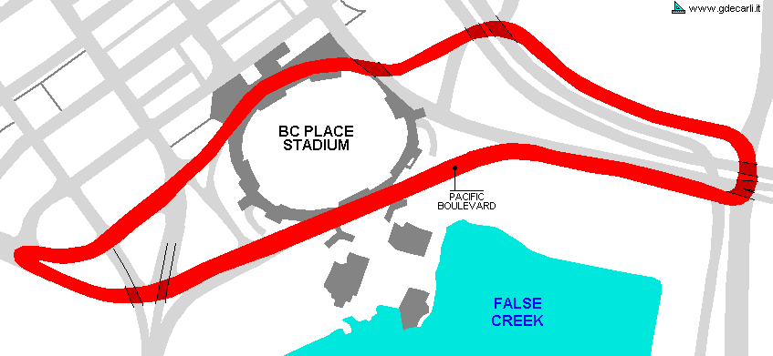
Vancouver, Pacific Place 1990÷1997
See this track layout with milermeter.com
(milermeter.com can be used in your browser, without installing anything; Google Earth is a program that must be installed in your computer)
Vancouver, Pacific Place 1998
See this track layout with milermeter.com
(milermeter.com can be used in your browser, without installing anything; Google Earth is a program that must be installed in your computer)
Vancouver, Pacific Place 1999÷2004
See this track layout with milermeter.com
(milermeter.com can be used in your browser, without installing anything; Google Earth is a program that must be installed in your computer)
| Updates | |||||||
| Date | Track layout | Years | Description by | Map by | Thanks to | Note | |
| June 16th 2008 | Pacific Place | 1990÷1997 | Guido de Carli | borough82 | Update | Description | |
| January 16th 2008 | Guido de Carli | Lorenzo Tommasi | Update | Description with map | |||
| August 12th 2005 | Guido de Carli | Update | Description | ||||
| June 4th 2005 | Pacific Place | 1989 | Guido de Carli | Update | Map | ||
| October 1st 2002 | Guido de Carli | Update | Map | ||||
| August 7th 2002 | Guido de Carli | Update | Description | ||||
| Not all eventual updates issued in last years are already visible in this list | |||||||


