| CZE - CZECH REPUBLIC | |||||||||||||||||
| VÍTKOVICE | |||||||||||||||||
| Description | |||||||||||||||||
| Location | Vítkovice, Ostrava T - Moravskoslezský kraj - Moravskoslezsko | ||||||||||||||||
| Location | |||||||||||||||||
| Latitude - Longitude | + 49°48'08" + 18°16'22" 49.802222 18.272778 | ||||||||||||||||
| UTM Coordinates | X = 303759.641 - Y = 5520209.826 - Zone 34U | ||||||||||||||||
| Aerial photo / Map (*) |  OpenStreetMap - Google Maps - Bing Maps - Flash Earth - Wikimapia - Mapy.cz OpenStreetMap - Google Maps - Bing Maps - Flash Earth - Wikimapia - Mapy.cz | ||||||||||||||||
| Altitude AMSL | 227 m - 745 ft | ||||||||||||||||
| Inauguration | 1973 | ||||||||||||||||
| Closing | 1990 | ||||||||||||||||
| Designer | |||||||||||||||||
| Sources and links (Translation) (**) |
| ||||||||||||||||
| Vítkovice | |||||
| Description | |||||
| Years | 1973÷1990 | ||||
| Direction |  Anticlockwise Anticlockwise | ||||
 Proposal Proposal |
NO | ||||
| No longer operational | YES | ||||
| Car Circuit | |||||
| Motorbike circuit | |||||
| Type | Street course | ||||
| Inauguration | 1973 | ||||
| Closing | 1990 | ||||
| Last update of this page | February 9th 2008 | ||||
| Info last update | |||||
| Designer | |||||
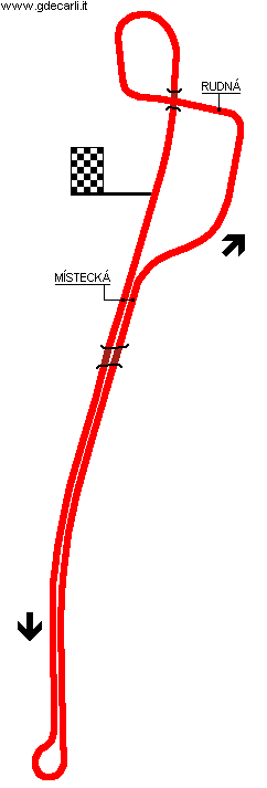
| Distinctive points | Místecká - Rudná | ||||
| length | 3200 m | 10499 ft | 1.988 mi | (3) | |
| length | 3200 m | 10499 ft | 1.988 mi | (1) | |
| length | 3190 m | 10466 ft | 1.982 mi | Calculated from aerial photo (*) | (2) |
Vítkovice
See this track layout with milermeter.com
(milermeter.com can be used in your browser, without installing anything; Google Earth is a program that must be installed in your computer)
| Updates | |||||||
| Date | Track layout | Years | Description by | Map by | Thanks to | Note | |
| February 9th 2008 | 1973÷1990 | Guido de Carli | Guido de Carli | David Griac (jpm) | Update | Description with map | |
| March 17th 2006 | 1973÷1990 | Guido de Carli | Roelard Smit | New | Description | ||
| Not all eventual updates issued in last years are already visible in this list | |||||||


